Marina Beach
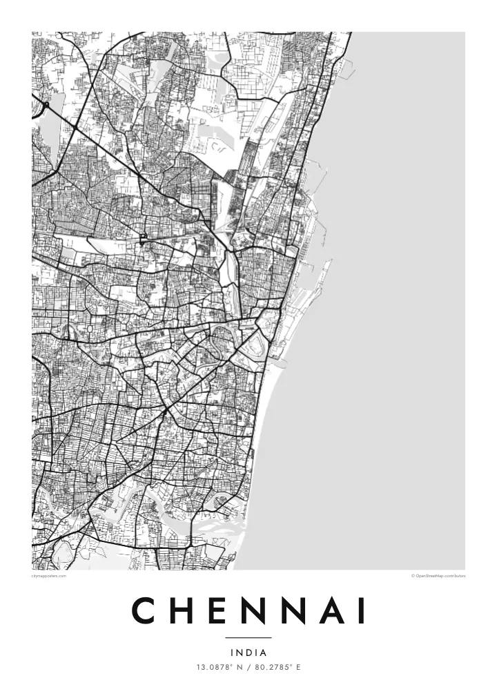
A long, broad strip of sand runs along the eastern edge of the city, giving the map a strong straight line against the open water of the Bay of Bengal.
Póster mapa minimalista · India
13.0878° N / 80.2785° E
A flat city along the Bay of Bengal, crossed by two rivers and edged by a very long urban beach.


Sidade ida, estilu lima
Hili estilu ida atu haree oinsá nia sai iha didin. Estilu hotu-hotu iha folin hanesan — imprime, kaixa moldura ka arkivu HD.
 Pixel loloos · arkivu imprime 24 × 36″
Moos atu imprime
Ida ne'e mak crop 100% husi arkivu imprime loloos. Poster ida-idak — imprime, kaixa moldura ka download — ami halo iha ami-nia servidor ho 300 DPI, to'o 7,200 × 10,800 pixel, atu dalan ki'ik liu mós sai klaru iha imprime 24 × 36″.
Iha Parede


Mapa
Chennai runs along the Coromandel Coast, and its eastern edge is a single, almost straight line of sand facing the Bay of Bengal. Marina Beach, among the longest urban beaches anywhere, stretches for several kilometres south of the port. Inland, the city spreads across very flat ground, so its streets form a dense, loosely organised network rather than a strict grid.
Two rivers, the Cooum and the Adyar, wind through the city before reaching the sea, and the Buckingham Canal runs roughly parallel to the coast. Fort St George, dating from 1644 and built by the English East India Company, sits near the harbour and marks the city's colonial beginnings. Anna Salai runs from there to the south-west as a principal artery.
Once known as Madras, Chennai grew from a handful of villages, and older neighbourhoods such as Mylapore still keep their own temple-centred street patterns. A Chennai map poster shows the long coastline, the curving rivers and the fine grain of streets that fills the space between them almost without a break.
A long, broad strip of sand runs along the eastern edge of the city, giving the map a strong straight line against the open water of the Bay of Bengal.
The Adyar River widens into a broad estuary before it meets the sea, one of the few large open shapes in the southern part of the city.
The fort near the harbour, dating from 1644, anchors the northern part of the centre and is where the colonial city of Madras began.
Halo ita-nia póster rasik
Aumenta data, naran ka liafuan rasik, troka estilu, tamañu ka orientasaun.
Preview grátis nian rezolusaun ki'ik no iha marka bee. Imprime no arkivu HD ami halo ho 300 DPI, to'o 7,200 × 10,800 px, laiha marka bee.
Tanba sa Chennai
Chennai is home, or was once home, to many people who now live far away, and a map of its streets and coastline is a simple way to keep it close. The long line of the beach makes the city instantly recognisable even in a minimal print.
Set the title and subtitle to whatever matters to you, whether a neighbourhood, a family name or a year, and add coordinates if you like. Choose one of five styles, then download HD files for $9 or order a matte printed poster.
Enkomenda poster Chennai| Tamañu imprime | Rezolusaun | Arkivu |
|---|---|---|
| 30 × 40 cm11.8 × 15.7″ | 3,543 × 4,724 px | PNG · PDF |
| 29.7 × 42 cm (A3)11.7 × 16.5″ | 3,508 × 4,961 px | PNG · PDF |
| 42 × 59.4 cm (A2)16.5 × 23.4″ | 4,961 × 7,016 px | PNG · PDF |
| 45.7 × 61 cm18 × 24″ | 5,400 × 7,200 px | PNG · PDF |
| 50 × 70 cm19.7 × 27.6″ | 5,906 × 8,268 px | PNG · PDF |
| 61 × 91.4 cm24 × 36″ | 7,200 × 10,800 px | PNG · PDF |
Atu kompara, previzaun gratuita luan 900 px, iha marka d'água no ba ekrã de'it. Arkivu HD iha rezolusaun to'o dala 8 boot liu iha direksaun ida-idak no imprime moos iha tamañu póster kompletu.
Hili estilu ida iha leten pájina, depois hili Poster Imprime — hili tamañu ida no, se hakarak, moldura ida — ka Arkivu Digital HD. Pagamentu halo iha pasu ida deit, no pájina enkomenda sei update kedas hafoin pagamentu remata.
Ami imprime iha papel matte kualidade aas 200 gsm, iha tamañu neen, husi 30 × 40 cm to'o 24 × 36″. Poster imprime hahú husi $39, haruka livre.
Bele. Hili moldura kayu solidu kór metan, mutin, oak natural ka kayu nakukun. Mai ho vidru la-kilat no prontu atu kandu iha didin. Poster ho moldura hahú husi $99, haruka livre.
Entrega gratuita ba país 60+. Poster ida-idak ami-nia parseiru impresaun besik liu mak imprime iha país 30+ no normalmente to'o iha loron-servisu 3–7. Ita bele haree estatutu no rastreiu iha Ha'u-nia Enkomenda. Países balu presiza semana 2–5, no iha fatin ne'ebé ami seidauk entrega, site sei hatete ba ita molok selu.
Haruka foto ba ami iha loron 14 hafoin simu, no ami sei imprime fali ho grátis ka selu fila fali osan.
Bele. Iha editor iha pájina ne'e, troka titulu, subtitulu no liña koordenadas ba buat ne'ebé ita hakarak, depois hili estilu no tamañu. Enkomenda imprime, moldura ka digital hotu-hotu uza sasán ita-nia desain loloos.
Ho $9 ita simu arkivu PNG 300 DPI no PDF prontu-imprime iha tamañu neen hotu, laiha marka bee, atu imprime iha fatin ida-ida. Seidauk lai serteza? Download uluk preview grátis ho marka bee.
