Cap-Vert peninsula
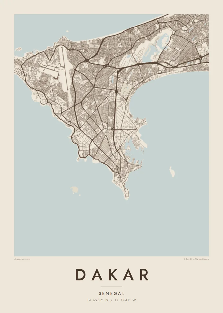
The city fills a hooked peninsula, with ocean on three sides and the mainland to the east, creating a strong, compact silhouette on the page.
Póster mapa minimalista · Senegal
14.6937° N / 17.4441° W
A city at the tip of a peninsula reaching into the Atlantic, the westernmost point of mainland Africa.


Sidade ida, estilu lima
Hili estilu ida atu haree oinsá nia sai iha didin. Estilu hotu-hotu iha folin hanesan — imprime, kaixa moldura ka arkivu HD.
 Pixel loloos · arkivu imprime 24 × 36″
Moos atu imprime
Ida ne'e mak crop 100% husi arkivu imprime loloos. Poster ida-idak — imprime, kaixa moldura ka download — ami halo iha ami-nia servidor ho 300 DPI, to'o 7,200 × 10,800 pixel, atu dalan ki'ik liu mós sai klaru iha imprime 24 × 36″.
Iha Parede


Mapa
Dakar occupies the Cap-Vert peninsula, which pushes out into the Atlantic from the coast of Senegal. At its western end, the Pointe des Almadies is the westernmost point of the African mainland. On a map the city is almost surrounded by water, with the open ocean along the north and west and a sheltered bay and harbour to the south and east.
The historic centre, known as the Plateau, sits on the southern tip, with a regular colonial-era street grid, the port and the main government buildings. From there, the city extends north and west across the peninsula in a mix of planned districts and older neighbourhoods, and coastal roads follow the cliffs and beaches around the edges.
Near the western shore rise the two Mamelles hills, one topped by a lighthouse and the other by the African Renaissance Monument. Offshore lies the small island of Gorée, a UNESCO site associated with the Atlantic slave trade. A Dakar map poster includes that scatter of islands and headlands, which gives the city one of the most recognisable outlines in West Africa.
The city fills a hooked peninsula, with ocean on three sides and the mainland to the east, creating a strong, compact silhouette on the page.
At the southern tip, a tight grid of streets marks the old centre and administrative quarter, set right beside the port and the sheltered harbour.
Small islands sit off the coast, Gorée to the southeast near the harbour and Ngor off the western tip, adding details that frame the peninsula.
Halo ita-nia póster rasik
Aumenta data, naran ka liafuan rasik, troka estilu, tamañu ka orientasaun.
Preview grátis nian rezolusaun ki'ik no iha marka bee. Imprime no arkivu HD ami halo ho 300 DPI, to'o 7,200 × 10,800 px, laiha marka bee.
Tanba sa Dakar
Dakar is a place people leave and return to, whether for work, family or study, and its peninsula shape is instantly recognisable. A map of the city holds the coastline, the Plateau and the islands in a single calm image.
Make it personal with a title, a subtitle and your own coordinates, perhaps naming a quarter or a date. Five styles are available, including Paper and Sand for warmer rooms, and the HD download covers six print sizes as 300 DPI PNG and PDF files.
Enkomenda poster Dakar| Tamañu imprime | Rezolusaun | Arkivu |
|---|---|---|
| 30 × 40 cm (11.8 × 15.7″) | 3,543 × 4,724 px | PNG · PDF |
| 29.7 × 42 cm (A3, 11.7 × 16.5″) | 3,508 × 4,961 px | PNG · PDF |
| 42 × 59.4 cm (A2, 16.5 × 23.4″) | 4,961 × 7,016 px | PNG · PDF |
| 45.7 × 61 cm (18 × 24″) | 5,400 × 7,200 px | PNG · PDF |
| 50 × 70 cm (19.7 × 27.6″) | 5,906 × 8,268 px | PNG · PDF |
| 61 × 91.4 cm (24 × 36″) | 7,200 × 10,800 px | PNG · PDF |
Atu kompara, previzaun gratuita luan 900 px, iha marka d'água no ba ekrã de'it. Arkivu HD iha rezolusaun to'o dala 8 boot liu iha direksaun ida-idak no imprime moos iha tamañu póster kompletu.
Hili estilu ida iha leten pájina, depois hili Poster Imprime — hili tamañu ida no, se hakarak, moldura ida — ka Arkivu Digital HD. Pagamentu halo iha pasu ida deit, no pájina enkomenda sei update kedas hafoin pagamentu remata.
Ami imprime iha papel matte kualidade aas 200 gsm, iha tamañu neen, husi 30 × 40 cm to'o 24 × 36″. Poster imprime hahú husi $39, haruka livre.
Bele. Hili moldura kayu solidu kór metan, mutin, oak natural ka kayu nakukun. Mai ho vidru la-kilat no prontu atu kandu iha didin. Poster ho moldura hahú husi $99, haruka livre.
Entrega gratuita ba mundu tomak. Poster ida-idak imprime husi ami-nia parseiru impresaun ne'ebé besik liu iha nasaun 30+ no normalmente to'o iha loron servisu 3–7. Ita bele haree estadu no tracking iha Ha'u-nia Pedidu. Nasaun balu foti semana 2–5, no iha nasaun ne'ebé ami seidauk entrega, sítiu hatudu ba ita molok selu.
Haruka foto ba ami iha loron 14 hafoin simu, no ami sei imprime fali ho grátis ka selu fila fali osan.
Bele. Iha editor iha pájina ne'e, troka titulu, subtitulu no liña koordenadas ba buat ne'ebé ita hakarak, depois hili estilu no tamañu. Enkomenda imprime, moldura ka digital hotu-hotu uza sasán ita-nia desain loloos.
Ho $9 ita simu arkivu PNG 300 DPI no PDF prontu-imprime iha tamañu neen hotu, laiha marka bee, atu imprime iha fatin ida-ida. Seidauk lai serteza? Download uluk preview grátis ho marka bee.
