Boyne Viaduct
Opened in 1855, the railway viaduct spans the Boyne east of the centre, its long straight line crossing the river and the quays below it in a single stroke on the map.
Póster mapa minimalista · Ireland
53.7189° N / 6.3478° W
An old port town on both banks of the Boyne, crossed by a tall railway viaduct near the river's mouth.




Sidade ida, estilu lima
Hili estilu ida atu haree oinsá nia sai iha didin. Estilu hotu-hotu iha folin hanesan — imprime, kaixa moldura ka arkivu HD.
 Pixel loloos · arkivu imprime 24 × 36″
Moos atu imprime
Ida ne'e mak crop 100% husi arkivu imprime loloos. Poster ida-idak — imprime, kaixa moldura ka download — ami halo iha ami-nia servidor ho 300 DPI, to'o 7,200 × 10,800 pixel, atu dalan ki'ik liu mós sai klaru iha imprime 24 × 36″.
Iha Parede


Mapa
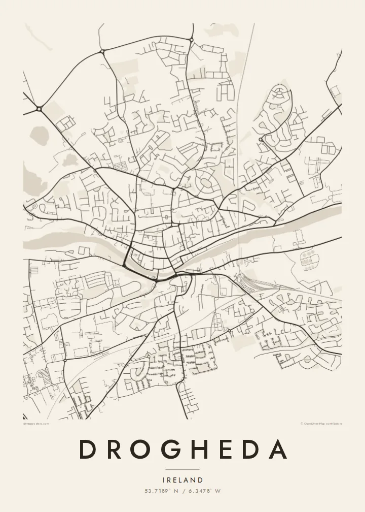
Drogheda stands on the River Boyne a few kilometres upstream from its mouth on the Irish Sea, and the town has grown on both banks, straddling the boundary between counties Louth and Meath. From above, the river cuts a clear line through the centre, with the medieval street pattern gathered along the north bank and the land rising on the south side toward Millmount.
Millmount, a prominent mound topped by a Martello tower, overlooks the town, and parts of the medieval walls survive, most notably St Laurence's Gate, a tall barbican on the eastern side of the old centre. The town was besieged by Oliver Cromwell in 1649, and St Peter's Church holds the preserved head of St Oliver Plunkett.
East of the centre, the Boyne Viaduct carries the Dublin–Belfast railway high above the river, one of the most striking structures on the Irish rail network. Upriver lie Brú na Bóinne and the site of the Battle of the Boyne. A Drogheda map poster frames the river, the viaduct and the old town in a single composition.
Opened in 1855, the railway viaduct spans the Boyne east of the centre, its long straight line crossing the river and the quays below it in a single stroke on the map.
North of the river, the old town keeps a compact pattern of narrow streets and lanes, with St Laurence's Gate marking the line of the former walls.
On the south bank, the mound of Millmount rises above the town with its Martello tower, the high point from which the whole river crossing can be seen.
Halo ita-nia póster rasik
Aumenta data, naran ka liafuan rasik, troka estilu, tamañu ka orientasaun.
Preview grátis nian rezolusaun ki'ik no iha marka bee. Imprime no arkivu HD ami halo ho 300 DPI, to'o 7,200 × 10,800 px, laiha marka bee.
Tanba sa Drogheda
Drogheda is a hometown for many who have moved to Dublin or further afield, and a gateway to the Boyne Valley for visitors. A map of its river, viaduct and old streets is a clear, understated way to keep the town close.
Add a family name or a date to the title and subtitle, adjust the coordinates line, and choose from five styles, including Noir and Blueprint. HD files cost $9 in six sizes, and printed posters ship from partners in more than 30 countries.
Enkomenda poster Drogheda| Tamañu imprime | Rezolusaun | Arkivu |
|---|---|---|
| 30 × 40 cm11.8 × 15.7″ | 3,543 × 4,724 px | PNG · PDF |
| 29.7 × 42 cm (A3)11.7 × 16.5″ | 3,508 × 4,961 px | PNG · PDF |
| 42 × 59.4 cm (A2)16.5 × 23.4″ | 4,961 × 7,016 px | PNG · PDF |
| 45.7 × 61 cm18 × 24″ | 5,400 × 7,200 px | PNG · PDF |
| 50 × 70 cm19.7 × 27.6″ | 5,906 × 8,268 px | PNG · PDF |
| 61 × 91.4 cm24 × 36″ | 7,200 × 10,800 px | PNG · PDF |
Atu kompara, previzaun gratuita luan 900 px, iha marka d'água no ba ekrã de'it. Arkivu HD iha rezolusaun to'o dala 8 boot liu iha direksaun ida-idak no imprime moos iha tamañu póster kompletu.
Hili estilu ida iha leten pájina, depois hili Poster Imprime — hili tamañu ida no, se hakarak, moldura ida — ka Arkivu Digital HD. Pagamentu halo iha pasu ida deit, no pájina enkomenda sei update kedas hafoin pagamentu remata.
Ami imprime iha papel matte kualidade aas 200 gsm, iha tamañu neen, husi 30 × 40 cm to'o 24 × 36″. Poster imprime hahú husi $39, haruka livre.
Bele. Hili moldura kayu solidu kór metan, mutin, oak natural ka kayu nakukun. Mai ho vidru la-kilat no prontu atu kandu iha didin. Poster ho moldura hahú husi $99, haruka livre.
Entrega gratuita ba país 60+. Poster ida-idak ami-nia parseiru impresaun besik liu mak imprime iha país 30+ no normalmente to'o iha loron-servisu 3–7. Ita bele haree estatutu no rastreiu iha Ha'u-nia Enkomenda. Países balu presiza semana 2–5, no iha fatin ne'ebé ami seidauk entrega, site sei hatete ba ita molok selu.
Haruka foto ba ami iha loron 14 hafoin simu, no ami sei imprime fali ho grátis ka selu fila fali osan.
Bele. Iha editor iha pájina ne'e, troka titulu, subtitulu no liña koordenadas ba buat ne'ebé ita hakarak, depois hili estilu no tamañu. Enkomenda imprime, moldura ka digital hotu-hotu uza sasán ita-nia desain loloos.
Ho $9 ita simu arkivu PNG 300 DPI no PDF prontu-imprime iha tamañu neen hotu, laiha marka bee, atu imprime iha fatin ida-ida. Seidauk lai serteza? Download uluk preview grátis ho marka bee.
