Doshisha campus
On the western hills, the university's Kyotanabe campus forms a large, clearly bounded area with its own internal roads and open spaces.
Póster mapa minimalista · Japan
34.8045° N / 135.7668° E
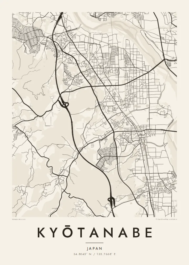
A long north–south town between Kyoto and Nara, shaped by parallel rail lines, the Kizu River and a hillside university campus.




Sidade ida, estilu lima
Hili estilu ida atu haree oinsá nia sai iha didin. Estilu hotu-hotu iha folin hanesan — imprime, kaixa moldura ka arkivu HD.
 Pixel loloos · arkivu imprime 24 × 36″
Moos atu imprime
Ida ne'e mak crop 100% husi arkivu imprime loloos. Poster ida-idak — imprime, kaixa moldura ka download — ami halo iha ami-nia servidor ho 300 DPI, to'o 7,200 × 10,800 pixel, atu dalan ki'ik liu mós sai klaru iha imprime 24 × 36″.
Iha Parede


Mapa
Kyōtanabe stretches along the corridor between Kyoto and Nara, and its map is organised by lines running north to south. Two railways, the JR Gakkentoshi Line and the Kintetsu Kyoto Line, run through the town, and residential neighbourhoods have grown up around their stations. To the east, the Kizu River runs along the edge of the municipality, flanked by embankments and open ground.
To the west, the land rises into low hills, where the large Kyotanabe campus of Doshisha University occupies a broad area of paths and buildings. Between the hills and the river, housing estates, farmland and older village centres mix together, giving the map a varied texture. Tea is still grown in the surrounding area, part of the southern Kyoto tea-growing tradition.
The town is also home to Ikkyū-ji, the temple where the Zen monk Ikkyū spent his final years. A Kyōtanabe map poster captures the shape of a commuter town that still keeps traces of an older rural landscape, with rail, river and hills defining its outline more clearly than any single centre.
On the western hills, the university's Kyotanabe campus forms a large, clearly bounded area with its own internal roads and open spaces.
Along the eastern edge, the river and its embankments form a long, flowing line that sets the town's boundary against the neighbouring municipalities.
The temple associated with the monk Ikkyū sits in a quieter part of town, a small precinct set apart from the grid of newer neighbourhoods.
Halo ita-nia póster rasik
Aumenta data, naran ka liafuan rasik, troka estilu, tamañu ka orientasaun.
Preview grátis nian rezolusaun ki'ik no iha marka bee. Imprime no arkivu HD ami halo ho 300 DPI, to'o 7,200 × 10,800 px, laiha marka bee.
Tanba sa Kyōtanabe
For Doshisha students and graduates, Kyōtanabe is where years of study took place, and for residents it is a calm home between two historic cities. The map suits a graduation, a first apartment or a family house.
The title and subtitle can hold a name, a year or a station, and the coordinates line can be edited. Choose one of five styles; Classic black & white keeps the rail lines sharp, and Paper softens the whole plan.
Enkomenda poster Kyōtanabe| Tamañu imprime | Rezolusaun | Arkivu |
|---|---|---|
| 30 × 40 cm11.8 × 15.7″ | 3,543 × 4,724 px | PNG · PDF |
| 29.7 × 42 cm (A3)11.7 × 16.5″ | 3,508 × 4,961 px | PNG · PDF |
| 42 × 59.4 cm (A2)16.5 × 23.4″ | 4,961 × 7,016 px | PNG · PDF |
| 45.7 × 61 cm18 × 24″ | 5,400 × 7,200 px | PNG · PDF |
| 50 × 70 cm19.7 × 27.6″ | 5,906 × 8,268 px | PNG · PDF |
| 61 × 91.4 cm24 × 36″ | 7,200 × 10,800 px | PNG · PDF |
Atu kompara, previzaun gratuita luan 900 px, iha marka d'água no ba ekrã de'it. Arkivu HD iha rezolusaun to'o dala 8 boot liu iha direksaun ida-idak no imprime moos iha tamañu póster kompletu.
Hili estilu ida iha leten pájina, depois hili Poster Imprime — hili tamañu ida no, se hakarak, moldura ida — ka Arkivu Digital HD. Pagamentu halo iha pasu ida deit, no pájina enkomenda sei update kedas hafoin pagamentu remata.
Ami imprime iha papel matte kualidade aas 200 gsm, iha tamañu neen, husi 30 × 40 cm to'o 24 × 36″. Poster imprime hahú husi $39, haruka livre.
Bele. Hili moldura kayu solidu kór metan, mutin, oak natural ka kayu nakukun. Mai ho vidru la-kilat no prontu atu kandu iha didin. Poster ho moldura hahú husi $99, haruka livre.
Entrega gratuita ba país 60+. Poster ida-idak ami-nia parseiru impresaun besik liu mak imprime iha país 30+ no normalmente to'o iha loron-servisu 3–7. Ita bele haree estatutu no rastreiu iha Ha'u-nia Enkomenda. Países balu presiza semana 2–5, no iha fatin ne'ebé ami seidauk entrega, site sei hatete ba ita molok selu.
Haruka foto ba ami iha loron 14 hafoin simu, no ami sei imprime fali ho grátis ka selu fila fali osan.
Bele. Iha editor iha pájina ne'e, troka titulu, subtitulu no liña koordenadas ba buat ne'ebé ita hakarak, depois hili estilu no tamañu. Enkomenda imprime, moldura ka digital hotu-hotu uza sasán ita-nia desain loloos.
Ho $9 ita simu arkivu PNG 300 DPI no PDF prontu-imprime iha tamañu neen hotu, laiha marka bee, atu imprime iha fatin ida-ida. Seidauk lai serteza? Download uluk preview grátis ho marka bee.
