Highway and railway
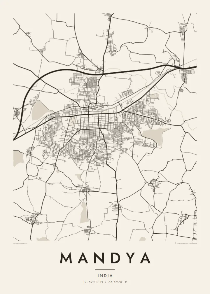
The Bengaluru–Mysuru highway and rail line run through the town side by side. On the poster they form a strong spine, with the town spreading out on both sides.
Póster mapa minimalista · India
12.5223° N / 76.8975° E
Karnataka's sugar town on the Bengaluru–Mysuru highway, surrounded by a grid of irrigation canals and cane fields




Sidade ida, estilu lima
Hili estilu ida atu haree oinsá nia sai iha didin. Estilu hotu-hotu iha folin hanesan — imprime, kaixa moldura ka arkivu HD.
 Pixel loloos · arkivu imprime 24 × 36″
Moos atu imprime
Ida ne'e mak crop 100% husi arkivu imprime loloos. Poster ida-idak — imprime, kaixa moldura ka download — ami halo iha ami-nia servidor ho 300 DPI, to'o 7,200 × 10,800 pixel, atu dalan ki'ik liu mós sai klaru iha imprime 24 × 36″.
Iha Parede


Mapa
Mandya lies in southern Karnataka, on the main highway and railway between Bengaluru and Mysuru. On the map the town is centred on this corridor. Streets gather on either side of the main road and rail line, and the land around it is laced with irrigation canals that divide the fields into a fine, regular pattern.
Mandya is widely known as the sugar city of Karnataka, because of the sugarcane grown across the district and the sugar factory established here in the 1930s. The irrigation that made this possible comes largely from the Krishna Raja Sagara dam on the Kaveri. The dam lies a short distance to the south-west, and its canal system, including the Visvesvaraya Canal, feeds the district's farmland.
A Mandya map poster captures a farming town at the centre of a watered landscape. There is a dense core along the highway, neighbourhoods on either side, and canals threading through fields to the edge of the frame. In black and white, the irrigation network becomes a delicate, almost architectural pattern.
The Bengaluru–Mysuru highway and rail line run through the town side by side. On the poster they form a strong spine, with the town spreading out on both sides.
Canals fed by the Kaveri reservoir cut across the farmland around Mandya. Their long, steady lines are among the most distinctive features of the map.
Sugarcane and paddy fields surround the town, divided by field channels and village roads. They give the poster's outer area a fine, patterned texture.
Halo ita-nia póster rasik
Aumenta data, naran ka liafuan rasik, troka estilu, tamañu ka orientasaun.
Preview grátis nian rezolusaun ki'ik no iha marka bee. Imprime no arkivu HD ami halo ho 300 DPI, to'o 7,200 × 10,800 px, laiha marka bee.
Tanba sa Mandya
For people from Mandya district and the Kaveri basin, this map holds a town and a landscape built on water and sugar. It is a warm, personal piece for a new home in Bengaluru or overseas.
Personalise the title, subtitle and coordinates line in English or Kannada transliteration. Choose from Classic black & white, Noir, Paper, Blueprint or Sand. The $9 digital download includes six print sizes as 300 DPI PNG and PDF files.
Enkomenda poster Mandya| Tamañu imprime | Rezolusaun | Arkivu |
|---|---|---|
| 30 × 40 cm (11.8 × 15.7″) | 3,543 × 4,724 px | PNG · PDF |
| 29.7 × 42 cm (A3, 11.7 × 16.5″) | 3,508 × 4,961 px | PNG · PDF |
| 42 × 59.4 cm (A2, 16.5 × 23.4″) | 4,961 × 7,016 px | PNG · PDF |
| 45.7 × 61 cm (18 × 24″) | 5,400 × 7,200 px | PNG · PDF |
| 50 × 70 cm (19.7 × 27.6″) | 5,906 × 8,268 px | PNG · PDF |
| 61 × 91.4 cm (24 × 36″) | 7,200 × 10,800 px | PNG · PDF |
Atu kompara, previzaun gratuita luan 900 px, iha marka d'água no ba ekrã de'it. Arkivu HD iha rezolusaun to'o dala 8 boot liu iha direksaun ida-idak no imprime moos iha tamañu póster kompletu.
Hili estilu ida iha leten pájina, depois hili Poster Imprime — hili tamañu ida no, se hakarak, moldura ida — ka Arkivu Digital HD. Pagamentu halo iha pasu ida deit, no pájina enkomenda sei update kedas hafoin pagamentu remata.
Ami imprime iha papel matte kualidade aas 200 gsm, iha tamañu neen, husi 30 × 40 cm to'o 24 × 36″. Poster imprime hahú husi $39, haruka livre.
Bele. Hili moldura kayu solidu kór metan, mutin, oak natural ka kayu nakukun. Mai ho vidru la-kilat no prontu atu kandu iha didin. Poster ho moldura hahú husi $99, haruka livre.
Entrega gratuita ba mundu tomak. Poster ida-idak imprime husi ami-nia parseiru impresaun ne'ebé besik liu iha nasaun 30+ no normalmente to'o iha loron servisu 3–7. Ita bele haree estadu no tracking iha Ha'u-nia Pedidu. Nasaun balu foti semana 2–5, no iha nasaun ne'ebé ami seidauk entrega, sítiu hatudu ba ita molok selu.
Haruka foto ba ami iha loron 14 hafoin simu, no ami sei imprime fali ho grátis ka selu fila fali osan.
Bele. Iha editor iha pájina ne'e, troka titulu, subtitulu no liña koordenadas ba buat ne'ebé ita hakarak, depois hili estilu no tamañu. Enkomenda imprime, moldura ka digital hotu-hotu uza sasán ita-nia desain loloos.
Ho $9 ita simu arkivu PNG 300 DPI no PDF prontu-imprime iha tamañu neen hotu, laiha marka bee, atu imprime iha fatin ida-ida. Seidauk lai serteza? Download uluk preview grátis ho marka bee.
