100-metre avenues
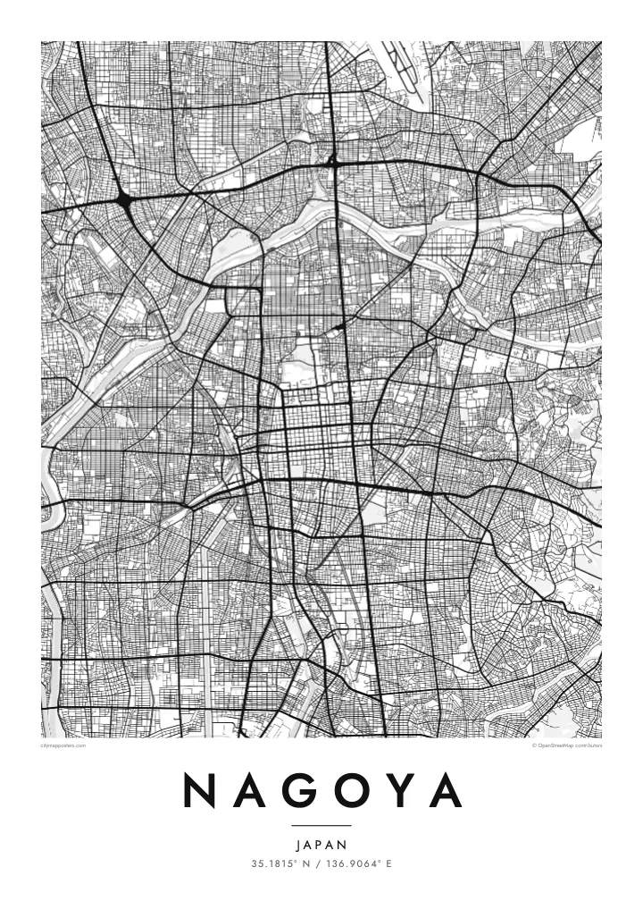
Hisaya-odori and Wakamiya-odori form a cross of unusually wide boulevards through the centre, lined with green space and clearly visible even at a small scale.
Póster mapa minimalista · Japan
35.1815° N / 136.9064° E
A planned castle town grown into a vast grid, cut by wide boulevards and opening south onto Ise Bay.


Sidade ida, estilu lima
Hili estilu ida atu haree oinsá nia sai iha didin. Estilu hotu-hotu iha folin hanesan — imprime, kaixa moldura ka arkivu HD.
 Pixel loloos · arkivu imprime 24 × 36″
Moos atu imprime
Ida ne'e mak crop 100% husi arkivu imprime loloos. Poster ida-idak — imprime, kaixa moldura ka download — ami halo iha ami-nia servidor ho 300 DPI, to'o 7,200 × 10,800 pixel, atu dalan ki'ik liu mós sai klaru iha imprime 24 × 36″.
Iha Parede


Mapa
Nagoya was laid out in the early seventeenth century as a castle town under Tokugawa Ieyasu, and the order of that plan still shows. The centre is a clear grid of square blocks running south from Nagoya Castle, and the city has since extended the pattern across the flat Nobi Plain in every direction, filling the map with regular, closely spaced streets.
After wartime destruction, Nagoya was rebuilt with some of the widest avenues in Japan. Hisaya-odori and Wakamiya-odori, each about a hundred metres wide, cross the centre as broad bands with parks down the middle. The Hori River, dug to serve the castle, runs south to the port, and the Shonai River curves along the west before the city opens onto Ise Bay.
Nagoya is the capital of Aichi Prefecture and the centre of one of Japan's largest manufacturing regions, home to Toyota and much of the country's car industry. Atsuta Shrine, one of the most important Shinto sites in Japan, lies in the south of the city. A Nagoya map poster turns this ordered plan into a precise, graphic print.
Hisaya-odori and Wakamiya-odori form a cross of unusually wide boulevards through the centre, lined with green space and clearly visible even at a small scale.
The castle grounds and their moats sit at the northern edge of the centre, a large rectangular block where the historic grid begins.
A canal-like river dug in the early 1600s, it runs south from the castle area to the port, linking the old town with the bay.
Halo ita-nia póster rasik
Aumenta data, naran ka liafuan rasik, troka estilu, tamañu ka orientasaun.
Preview grátis nian rezolusaun ki'ik no iha marka bee. Imprime no arkivu HD ami halo ho 300 DPI, to'o 7,200 × 10,800 px, laiha marka bee.
Tanba sa Nagoya
Nagoya's orderly grid and broad avenues make a clean, architectural print, well suited to anyone who appreciates planning and structure. It also marks personal ties: a company posting in Aichi, a hometown, or a first apartment near Sakae or Osu.
Personalise the title, subtitle and coordinates, then choose from Classic black & white, Noir, Paper, Blueprint and Sand. Blueprint in particular suits the geometry of the city. Download HD files for $9 or order a matte print shipped from partners in more than 30 countries.
Enkomenda poster Nagoya| Tamañu imprime | Rezolusaun | Arkivu |
|---|---|---|
| 30 × 40 cm11.8 × 15.7″ | 3,543 × 4,724 px | PNG · PDF |
| 29.7 × 42 cm (A3)11.7 × 16.5″ | 3,508 × 4,961 px | PNG · PDF |
| 42 × 59.4 cm (A2)16.5 × 23.4″ | 4,961 × 7,016 px | PNG · PDF |
| 45.7 × 61 cm18 × 24″ | 5,400 × 7,200 px | PNG · PDF |
| 50 × 70 cm19.7 × 27.6″ | 5,906 × 8,268 px | PNG · PDF |
| 61 × 91.4 cm24 × 36″ | 7,200 × 10,800 px | PNG · PDF |
Atu kompara, previzaun gratuita luan 900 px, iha marka d'água no ba ekrã de'it. Arkivu HD iha rezolusaun to'o dala 8 boot liu iha direksaun ida-idak no imprime moos iha tamañu póster kompletu.
Hili estilu ida iha leten pájina, depois hili Poster Imprime — hili tamañu ida no, se hakarak, moldura ida — ka Arkivu Digital HD. Pagamentu halo iha pasu ida deit, no pájina enkomenda sei update kedas hafoin pagamentu remata.
Ami imprime iha papel matte kualidade aas 200 gsm, iha tamañu neen, husi 30 × 40 cm to'o 24 × 36″. Poster imprime hahú husi $39, haruka livre.
Bele. Hili moldura kayu solidu kór metan, mutin, oak natural ka kayu nakukun. Mai ho vidru la-kilat no prontu atu kandu iha didin. Poster ho moldura hahú husi $99, haruka livre.
Entrega gratuita ba país 60+. Poster ida-idak ami-nia parseiru impresaun besik liu mak imprime iha país 30+ no normalmente to'o iha loron-servisu 3–7. Ita bele haree estatutu no rastreiu iha Ha'u-nia Enkomenda. Países balu presiza semana 2–5, no iha fatin ne'ebé ami seidauk entrega, site sei hatete ba ita molok selu.
Haruka foto ba ami iha loron 14 hafoin simu, no ami sei imprime fali ho grátis ka selu fila fali osan.
Bele. Iha editor iha pájina ne'e, troka titulu, subtitulu no liña koordenadas ba buat ne'ebé ita hakarak, depois hili estilu no tamañu. Enkomenda imprime, moldura ka digital hotu-hotu uza sasán ita-nia desain loloos.
Ho $9 ita simu arkivu PNG 300 DPI no PDF prontu-imprime iha tamañu neen hotu, laiha marka bee, atu imprime iha fatin ida-ida. Seidauk lai serteza? Download uluk preview grátis ho marka bee.
