Town grid
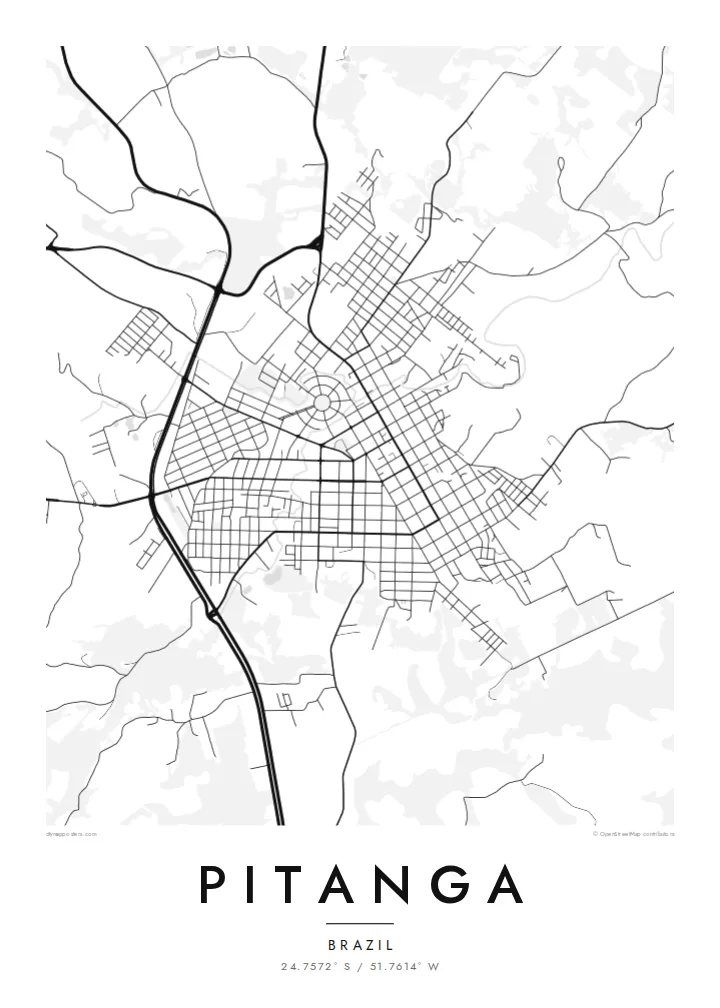
The central streets follow a mostly regular plan of rectangular blocks. On the poster they form a dense, tidy core that stands out from the countryside.
Póster mapa minimalista · Brazil
24.7572° S / 51.7614° W
An interior Paraná town on the high plateau, its regular street grid surrounded by rolling farmland and roads leading to the countryside.


Sidade ida, estilu lima
Hili estilu ida atu haree oinsá nia sai iha didin. Estilu hotu-hotu iha folin hanesan — imprime, kaixa moldura ka arkivu HD.
 Pixel loloos · arkivu imprime 24 × 36″
Moos atu imprime
Ida ne'e mak crop 100% husi arkivu imprime loloos. Poster ida-idak — imprime, kaixa moldura ka download — ami halo iha ami-nia servidor ho 300 DPI, to'o 7,200 × 10,800 pixel, atu dalan ki'ik liu mós sai klaru iha imprime 24 × 36″.
Iha Parede


Mapa
Pitanga lies in central Paraná, on the rolling plateau that covers much of the state's interior. Like many towns in southern Brazil founded or expanded in the twentieth century, its centre is a fairly regular grid. On the map it appears as an orderly block of streets set among the more irregular lines of rural roads and field boundaries.
The surrounding area is agricultural, and that shows clearly from above. Roads leave town in several directions and branch into smaller tracks that divide the land into farms. Streams and patches of woodland cut through the fields and add soft, curving lines to the landscape. The town's edge is well defined, with a clear shift from urban blocks to open country.
The name is shared with the pitanga, the small ribbed red fruit native to Brazil, whose name comes from Tupi. A Pitanga map poster shows the town in its setting: a compact grid, the roads that link it to the plateau, and the patchwork of rural land around it.
The central streets follow a mostly regular plan of rectangular blocks. On the poster they form a dense, tidy core that stands out from the countryside.
Several roads leave town toward neighbouring communities and farms. They extend outward like spokes and link the grid to the wider plateau.
Small watercourses and wooded strips wind through the farmland around town. Their curved lines contrast with the straight streets of the centre.
Halo ita-nia póster rasik
Aumenta data, naran ka liafuan rasik, troka estilu, tamañu ka orientasaun.
Preview grátis nian rezolusaun ki'ik no iha marka bee. Imprime no arkivu HD ami halo ho 300 DPI, to'o 7,200 × 10,800 px, laiha marka bee.
Tanba sa Pitanga
People in Brazil's interior often feel deeply connected to their home town, even after moving to a state capital or abroad. A map of Pitanga keeps that connection visible, drawn simply enough to suit almost any room.
Change the title, subtitle and coordinates line, for example to add a family name or a year, and pick Classic black and white, Noir, Paper, Blueprint or Sand. Digital files are $9 and include 300 DPI PNGs and print-ready PDFs with no watermark.
Enkomenda poster Pitanga| Tamañu imprime | Rezolusaun | Arkivu |
|---|---|---|
| 30 × 40 cm11.8 × 15.7″ | 3,543 × 4,724 px | PNG · PDF |
| 29.7 × 42 cm (A3)11.7 × 16.5″ | 3,508 × 4,961 px | PNG · PDF |
| 42 × 59.4 cm (A2)16.5 × 23.4″ | 4,961 × 7,016 px | PNG · PDF |
| 45.7 × 61 cm18 × 24″ | 5,400 × 7,200 px | PNG · PDF |
| 50 × 70 cm19.7 × 27.6″ | 5,906 × 8,268 px | PNG · PDF |
| 61 × 91.4 cm24 × 36″ | 7,200 × 10,800 px | PNG · PDF |
Atu kompara, previzaun gratuita luan 900 px, iha marka d'água no ba ekrã de'it. Arkivu HD iha rezolusaun to'o dala 8 boot liu iha direksaun ida-idak no imprime moos iha tamañu póster kompletu.
Hili estilu ida iha leten pájina, depois hili Poster Imprime — hili tamañu ida no, se hakarak, moldura ida — ka Arkivu Digital HD. Pagamentu halo iha pasu ida deit, no pájina enkomenda sei update kedas hafoin pagamentu remata.
Ami imprime iha papel matte kualidade aas 200 gsm, iha tamañu neen, husi 30 × 40 cm to'o 24 × 36″. Poster imprime hahú husi $39, haruka livre.
Bele. Hili moldura kayu solidu kór metan, mutin, oak natural ka kayu nakukun. Mai ho vidru la-kilat no prontu atu kandu iha didin. Poster ho moldura hahú husi $99, haruka livre.
Entrega gratuita ba país 60+. Poster ida-idak ami-nia parseiru impresaun besik liu mak imprime iha país 30+ no normalmente to'o iha loron-servisu 3–7. Ita bele haree estatutu no rastreiu iha Ha'u-nia Enkomenda. Países balu presiza semana 2–5, no iha fatin ne'ebé ami seidauk entrega, site sei hatete ba ita molok selu.
Haruka foto ba ami iha loron 14 hafoin simu, no ami sei imprime fali ho grátis ka selu fila fali osan.
Bele. Iha editor iha pájina ne'e, troka titulu, subtitulu no liña koordenadas ba buat ne'ebé ita hakarak, depois hili estilu no tamañu. Enkomenda imprime, moldura ka digital hotu-hotu uza sasán ita-nia desain loloos.
Ho $9 ita simu arkivu PNG 300 DPI no PDF prontu-imprime iha tamañu neen hotu, laiha marka bee, atu imprime iha fatin ida-ida. Seidauk lai serteza? Download uluk preview grátis ho marka bee.
