East Lake Tohopekaliga
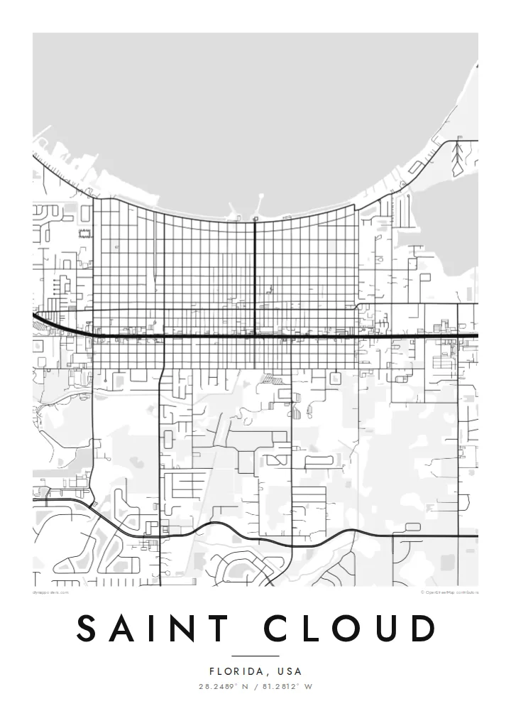
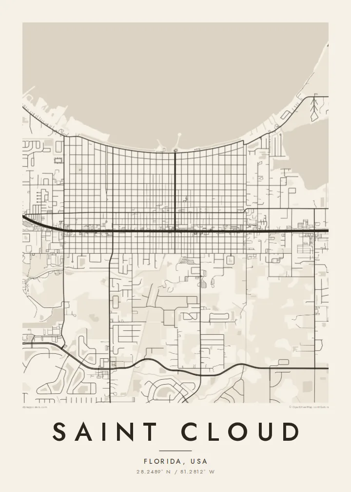
The large lake borders the town to the north, forming a wide, calm shape on the map with the lakefront park and marina along its edge.
Póster mapa minimalista · United States
28.2489° N / 81.2812° W
A Central Florida grid running down to the shore of East Lake Tohopekaliga, with lakes scattered across the suburbs



Sidade ida, estilu lima
Hili estilu ida atu haree oinsá nia sai iha didin. Estilu hotu-hotu iha folin hanesan — imprime, kaixa moldura ka arkivu HD.
 Pixel loloos · arkivu imprime 24 × 36″
Moos atu imprime
Ida ne'e mak crop 100% husi arkivu imprime loloos. Poster ida-idak — imprime, kaixa moldura ka download — ami halo iha ami-nia servidor ho 300 DPI, to'o 7,200 × 10,800 pixel, atu dalan ki'ik liu mós sai klaru iha imprime 24 × 36″.
Iha Parede


Mapa
Saint Cloud sits in Osceola County, south-east of Orlando, on the southern shore of East Lake Tohopekaliga. The older town is laid out as a regular grid of numbered streets and avenues running toward the lakefront, while newer neighbourhoods spread outward in curving subdivisions. Across the map, smaller lakes and wetlands appear as rounded white shapes.
The town was founded in the early twentieth century as a settlement for Union veterans of the American Civil War, and it grew as a planned community with a straightforward street pattern. Today it is a growing residential city within the Orlando area, but its historic grid and lakefront park still define the centre.
A Saint Cloud map poster brings together the lake, the straight lines of the original town and the looser forms of newer development. East Lake Tohopekaliga fills the top of the frame as a broad open surface, and the grid meets it directly. The result is a crisp and balanced composition that reads well at any size.
The large lake borders the town to the north, forming a wide, calm shape on the map with the lakefront park and marina along its edge.
The original town is laid out in a regular grid of numbered streets and avenues, running down toward the lake in straight, even lines.
Smaller lakes and wetland areas scatter across the outskirts, interrupting the suburban street patterns with smooth, irregular shapes.
Halo ita-nia póster rasik
Aumenta data, naran ka liafuan rasik, troka estilu, tamañu ka orientasaun.
Preview grátis nian rezolusaun ki'ik no iha marka bee. Imprime no arkivu HD ami halo ho 300 DPI, to'o 7,200 × 10,800 px, laiha marka bee.
Tanba sa Saint Cloud
Saint Cloud is home to long-time Florida families and many newer arrivals in the Orlando area. A map of the lakefront grid is a good way to mark a first home, a move south or years spent by the lake.
You can personalise the title, subtitle and coordinates line with names, dates or a street. Choose Classic black & white, Noir, Paper, Blueprint or Sand; Blueprint makes the lake especially striking.
Enkomenda poster Saint Cloud| Tamañu imprime | Rezolusaun | Arkivu |
|---|---|---|
| 30 × 40 cm11.8 × 15.7″ | 3,543 × 4,724 px | PNG · PDF |
| 29.7 × 42 cm (A3)11.7 × 16.5″ | 3,508 × 4,961 px | PNG · PDF |
| 42 × 59.4 cm (A2)16.5 × 23.4″ | 4,961 × 7,016 px | PNG · PDF |
| 45.7 × 61 cm18 × 24″ | 5,400 × 7,200 px | PNG · PDF |
| 50 × 70 cm19.7 × 27.6″ | 5,906 × 8,268 px | PNG · PDF |
| 61 × 91.4 cm24 × 36″ | 7,200 × 10,800 px | PNG · PDF |
Atu kompara, previzaun gratuita luan 900 px, iha marka d'água no ba ekrã de'it. Arkivu HD iha rezolusaun to'o dala 8 boot liu iha direksaun ida-idak no imprime moos iha tamañu póster kompletu.
Hili estilu ida iha leten pájina, depois hili Poster Imprime — hili tamañu ida no, se hakarak, moldura ida — ka Arkivu Digital HD. Pagamentu halo iha pasu ida deit, no pájina enkomenda sei update kedas hafoin pagamentu remata.
Ami imprime iha papel matte kualidade aas 200 gsm, iha tamañu neen, husi 30 × 40 cm to'o 24 × 36″. Poster imprime hahú husi $39, haruka livre.
Bele. Hili moldura kayu solidu kór metan, mutin, oak natural ka kayu nakukun. Mai ho vidru la-kilat no prontu atu kandu iha didin. Poster ho moldura hahú husi $99, haruka livre.
Entrega gratuita ba país 60+. Poster ida-idak ami-nia parseiru impresaun besik liu mak imprime iha país 30+ no normalmente to'o iha loron-servisu 3–7. Ita bele haree estatutu no rastreiu iha Ha'u-nia Enkomenda. Países balu presiza semana 2–5, no iha fatin ne'ebé ami seidauk entrega, site sei hatete ba ita molok selu.
Haruka foto ba ami iha loron 14 hafoin simu, no ami sei imprime fali ho grátis ka selu fila fali osan.
Bele. Iha editor iha pájina ne'e, troka titulu, subtitulu no liña koordenadas ba buat ne'ebé ita hakarak, depois hili estilu no tamañu. Enkomenda imprime, moldura ka digital hotu-hotu uza sasán ita-nia desain loloos.
Ho $9 ita simu arkivu PNG 300 DPI no PDF prontu-imprime iha tamañu neen hotu, laiha marka bee, atu imprime iha fatin ida-ida. Seidauk lai serteza? Download uluk preview grátis ho marka bee.
