Mbomou river
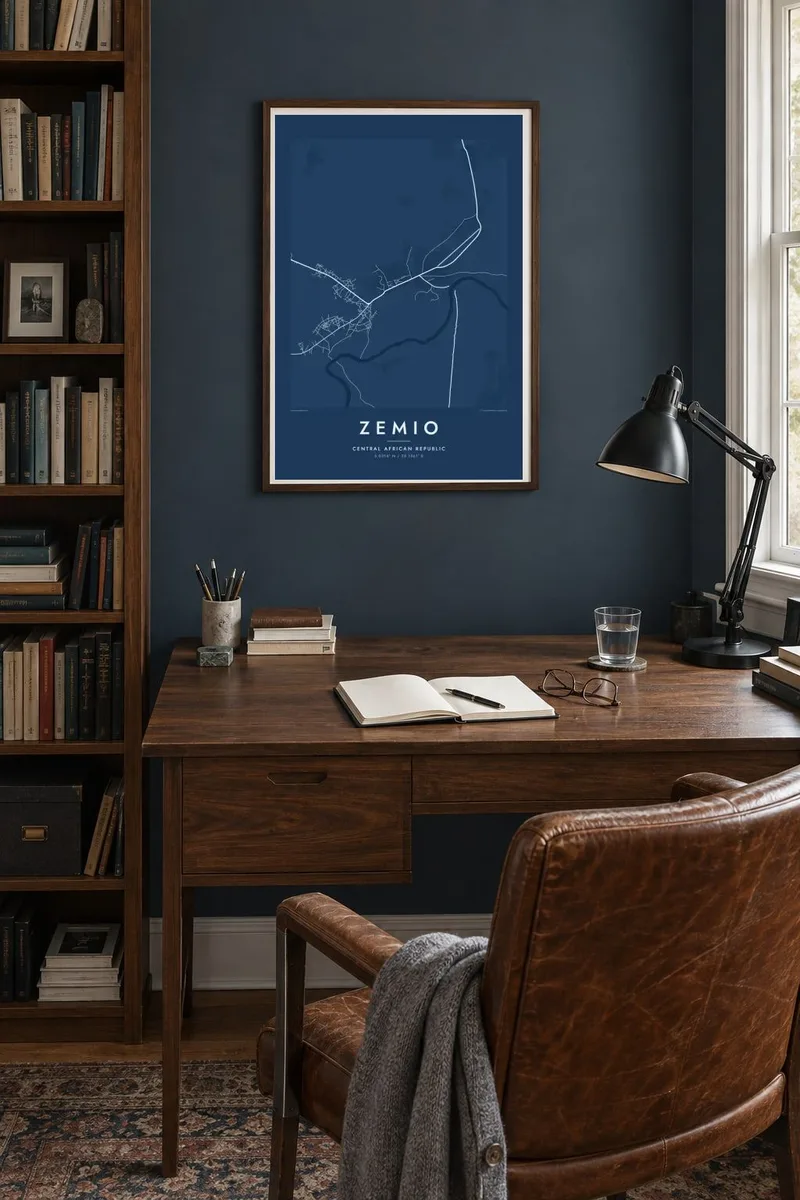
The river runs along the southern edge of Zemio and marks the border with the DR Congo, drawn as a broad, winding band across the map.
Póster mapa minimalista · Central African Republic
5.0314° N / 25.1361° E
A remote town on the Mbomou river in south-eastern Central African Republic, looking across the water to the Congo.


Sidade ida, estilu lima
Hili estilu ida atu haree oinsá nia sai iha didin. Estilu hotu-hotu iha folin hanesan — imprime, kaixa moldura ka arkivu HD.
 Pixel loloos · arkivu imprime 24 × 36″
Moos atu imprime
Ida ne'e mak crop 100% husi arkivu imprime loloos. Poster ida-idak — imprime, kaixa moldura ka download — ami halo iha ami-nia servidor ho 300 DPI, to'o 7,200 × 10,800 pixel, atu dalan ki'ik liu mós sai klaru iha imprime 24 × 36″.
Iha Parede


Mapa
Zemio lies in Haut-Mbomou prefecture in the south-east of the Central African Republic, on the northern bank of the Mbomou river. The river forms the border with the Democratic Republic of the Congo, and it is the strongest feature on the map: a wide, winding line along the southern edge of the town, with the Congolese bank opposite.
The town is small and loosely organised, with neighbourhoods of low houses and yards spread along a few main tracks. Roads lead west and east toward other towns of the Mbomou region, crossing savanna and wooded land. This is one of the most remote parts of the country, and the road network is sparse.
The area has been through long periods of insecurity, and humanitarian organisations working with displaced communities have been based in Zemio at times. A Zemio map poster shows the town in its essential form: a settlement on a river border, a few roads reaching into the landscape and the quiet geometry of a place far from any major city.
The river runs along the southern edge of Zemio and marks the border with the DR Congo, drawn as a broad, winding band across the map.
Neighbourhoods spread along the northern bank in an open, irregular pattern, and in several places their tracks and lanes reach down to the water.
A few main tracks lead away from town through savanna and woodland. They are the only long lines connecting Zemio with the rest of Haut-Mbomou.
Halo ita-nia póster rasik
Aumenta data, naran ka liafuan rasik, troka estilu, tamañu ka orientasaun.
Preview grátis nian rezolusaun ki'ik no iha marka bee. Imprime no arkivu HD ami halo ho 300 DPI, to'o 7,200 × 10,800 px, laiha marka bee.
Tanba sa Zemio
Zemio matters to people from Haut-Mbomou, to aid workers who have spent time there and to anyone with a connection to this corner of Central Africa. A map of the town is a respectful, personal record of the place.
Personalise the title, subtitle and coordinates with a date or a name. Choose Classic black & white, Noir, Paper, Blueprint or Sand. Download the HD files for $9, with six print sizes, each as a 300 DPI PNG and a print-ready PDF.
Enkomenda poster Zemio| Tamañu imprime | Rezolusaun | Arkivu |
|---|---|---|
| 30 × 40 cm11.8 × 15.7″ | 3,543 × 4,724 px | PNG · PDF |
| 29.7 × 42 cm (A3)11.7 × 16.5″ | 3,508 × 4,961 px | PNG · PDF |
| 42 × 59.4 cm (A2)16.5 × 23.4″ | 4,961 × 7,016 px | PNG · PDF |
| 45.7 × 61 cm18 × 24″ | 5,400 × 7,200 px | PNG · PDF |
| 50 × 70 cm19.7 × 27.6″ | 5,906 × 8,268 px | PNG · PDF |
| 61 × 91.4 cm24 × 36″ | 7,200 × 10,800 px | PNG · PDF |
Atu kompara, previzaun gratuita luan 900 px, iha marka d'água no ba ekrã de'it. Arkivu HD iha rezolusaun to'o dala 8 boot liu iha direksaun ida-idak no imprime moos iha tamañu póster kompletu.
Hili estilu ida iha leten pájina, depois hili Poster Imprime — hili tamañu ida no, se hakarak, moldura ida — ka Arkivu Digital HD. Pagamentu halo iha pasu ida deit, no pájina enkomenda sei update kedas hafoin pagamentu remata.
Ami imprime iha papel matte kualidade aas 200 gsm, iha tamañu neen, husi 30 × 40 cm to'o 24 × 36″. Poster imprime hahú husi $39, haruka livre.
Bele. Hili moldura kayu solidu kór metan, mutin, oak natural ka kayu nakukun. Mai ho vidru la-kilat no prontu atu kandu iha didin. Poster ho moldura hahú husi $99, haruka livre.
Entrega gratuita ba país 60+. Poster ida-idak ami-nia parseiru impresaun besik liu mak imprime iha país 30+ no normalmente to'o iha loron-servisu 3–7. Ita bele haree estatutu no rastreiu iha Ha'u-nia Enkomenda. Países balu presiza semana 2–5, no iha fatin ne'ebé ami seidauk entrega, site sei hatete ba ita molok selu.
Haruka foto ba ami iha loron 14 hafoin simu, no ami sei imprime fali ho grátis ka selu fila fali osan.
Bele. Iha editor iha pájina ne'e, troka titulu, subtitulu no liña koordenadas ba buat ne'ebé ita hakarak, depois hili estilu no tamañu. Enkomenda imprime, moldura ka digital hotu-hotu uza sasán ita-nia desain loloos.
Ho $9 ita simu arkivu PNG 300 DPI no PDF prontu-imprime iha tamañu neen hotu, laiha marka bee, atu imprime iha fatin ida-ida. Seidauk lai serteza? Download uluk preview grátis ho marka bee.
