Yalu River channels
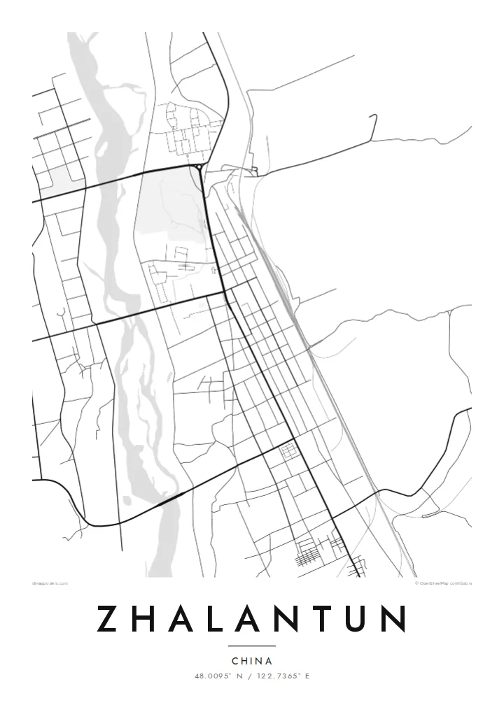
The river divides into several braided arms through town, leaving islands and green strips that break up the street pattern in fluid, irregular shapes.
Póster mapa minimalista · China
48.0095° N / 122.7365° E
A long valley town following the Yalu River out of the Greater Khingan foothills, with streets strung along the water and rail


Sidade ida, estilu lima
Hili estilu ida atu haree oinsá nia sai iha didin. Estilu hotu-hotu iha folin hanesan — imprime, kaixa moldura ka arkivu HD.
 Pixel loloos · arkivu imprime 24 × 36″
Moos atu imprime
Ida ne'e mak crop 100% husi arkivu imprime loloos. Poster ida-idak — imprime, kaixa moldura ka download — ami halo iha ami-nia servidor ho 300 DPI, to'o 7,200 × 10,800 pixel, atu dalan ki'ik liu mós sai klaru iha imprime 24 × 36″.
Iha Parede


Mapa
Zhalantun lies in the far east of Inner Mongolia, where the forested slopes of the Greater Khingan range drop toward the Songnen plain. The city stretches along the valley of the Yalu River, a tributary of the Nen. That gives the street plan a stretched, directional shape rather than a round centre. Hills close in on both sides, and the river braids through the middle.
The railway that once formed part of the Chinese Eastern line runs through the valley, and the town grew around its stations. Today Zhalantun is known across the region for its landscape: river islands, wooded ridges and parks that fold into the urban edge. On a map this appears as a city that keeps giving way to terrain.
A Zhalantun map poster picks up that tension between grid and valley. Blocks line up neatly near the rail corridor and then break apart where the river splits into channels and islands. Contours are not drawn, but you can read them in the gaps. Streets end where the slopes begin, and the valley floor holds almost everything built.
The river divides into several braided arms through town, leaving islands and green strips that break up the street pattern in fluid, irregular shapes.
The historic east–west railway runs straight along the valley floor, and the denser blocks of the city are aligned with it.
Hills press in from both sides, so the built area ends in sharp lines where slopes begin, a boundary that reads clearly in black and white.
Halo ita-nia póster rasik
Aumenta data, naran ka liafuan rasik, troka estilu, tamañu ka orientasaun.
Preview grátis nian rezolusaun ki'ik no iha marka bee. Imprime no arkivu HD ami halo ho 300 DPI, to'o 7,200 × 10,800 px, laiha marka bee.
Tanba sa Zhalantun
Zhalantun appeals to people who value the place where a town meets wild country. The map shows a city shaped by its river and ridges, a steady reminder of northern forests and long rail journeys, and it suits a calm, uncluttered room.
Add a title, a subtitle and a coordinates line of your choosing, perhaps a family name or a year you moved. Then pick Classic black & white, Noir, Paper, Blueprint or Sand. Paper and Sand bring out the softer river forms.
Enkomenda poster Zhalantun| Tamañu imprime | Rezolusaun | Arkivu |
|---|---|---|
| 30 × 40 cm11.8 × 15.7″ | 3,543 × 4,724 px | PNG · PDF |
| 29.7 × 42 cm (A3)11.7 × 16.5″ | 3,508 × 4,961 px | PNG · PDF |
| 42 × 59.4 cm (A2)16.5 × 23.4″ | 4,961 × 7,016 px | PNG · PDF |
| 45.7 × 61 cm18 × 24″ | 5,400 × 7,200 px | PNG · PDF |
| 50 × 70 cm19.7 × 27.6″ | 5,906 × 8,268 px | PNG · PDF |
| 61 × 91.4 cm24 × 36″ | 7,200 × 10,800 px | PNG · PDF |
Atu kompara, previzaun gratuita luan 900 px, iha marka d'água no ba ekrã de'it. Arkivu HD iha rezolusaun to'o dala 8 boot liu iha direksaun ida-idak no imprime moos iha tamañu póster kompletu.
Hili estilu ida iha leten pájina, depois hili Poster Imprime — hili tamañu ida no, se hakarak, moldura ida — ka Arkivu Digital HD. Pagamentu halo iha pasu ida deit, no pájina enkomenda sei update kedas hafoin pagamentu remata.
Ami imprime iha papel matte kualidade aas 200 gsm, iha tamañu neen, husi 30 × 40 cm to'o 24 × 36″. Poster imprime hahú husi $39, haruka livre.
Bele. Hili moldura kayu solidu kór metan, mutin, oak natural ka kayu nakukun. Mai ho vidru la-kilat no prontu atu kandu iha didin. Poster ho moldura hahú husi $99, haruka livre.
Entrega gratuita ba país 60+. Poster ida-idak ami-nia parseiru impresaun besik liu mak imprime iha país 30+ no normalmente to'o iha loron-servisu 3–7. Ita bele haree estatutu no rastreiu iha Ha'u-nia Enkomenda. Países balu presiza semana 2–5, no iha fatin ne'ebé ami seidauk entrega, site sei hatete ba ita molok selu.
Haruka foto ba ami iha loron 14 hafoin simu, no ami sei imprime fali ho grátis ka selu fila fali osan.
Bele. Iha editor iha pájina ne'e, troka titulu, subtitulu no liña koordenadas ba buat ne'ebé ita hakarak, depois hili estilu no tamañu. Enkomenda imprime, moldura ka digital hotu-hotu uza sasán ita-nia desain loloos.
Ho $9 ita simu arkivu PNG 300 DPI no PDF prontu-imprime iha tamañu neen hotu, laiha marka bee, atu imprime iha fatin ida-ida. Seidauk lai serteza? Download uluk preview grátis ho marka bee.
