Cul-de-sac neighbourhoods
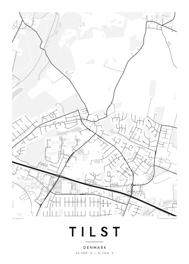
Residential areas are built around short dead-end streets and loops, which form leaf-like clusters on the map and give the poster its distinctive rhythm.
โปสเตอร์แผนที่มินิมอล · เดนมาร์ก
56.1938° N / 10.1128° E
A suburban town on the western edge of Aarhus, with looping residential streets that give way to open Jutland fields.


หนึ่งเมือง ห้าอารมณ์
แตะเลือกสไตล์เพื่อดูภาพบนผนัง ทุกสไตล์ราคาเท่ากัน ไม่ว่าจะเป็นแบบพิมพ์ ใส่กรอบ หรือไฟล์ HD
 พิกเซลจริง · ไฟล์พิมพ์ขนาด 24 × 36″
คมชัดระดับงานพิมพ์
นี่คือภาพครอปจากไฟล์พิมพ์จริงแบบ 100% โปสเตอร์ทุกใบ ไม่ว่าจะพิมพ์ ใส่กรอบ หรือดาวน์โหลด จะถูกเรนเดอร์บนเซิร์ฟเวอร์ของเราที่ 300 DPI สูงสุดถึง 7,200 × 10,800 พิกเซล เพื่อให้แม้แต่ซอยเล็กที่สุดยังคมชัดบนงานพิมพ์ขนาด 24 × 36″
บนผนัง


แผนที่
Tilst lies on the western edge of Aarhus in Central Jutland, close enough to the city to count as a suburb but still bordered by farmland. The map shows a pattern typical of Danish suburban growth: residential neighbourhoods of curving streets, loops and cul-de-sacs, planned in stages and separated by green strips, footpaths and small open spaces.
Unlike a grid, the street network branches and closes on itself. Each neighbourhood has its own internal loop, joined to a few collector roads that lead toward the city centre in the east. To the west and north the houses stop and fields begin, so the map shows the exact point where the city meets the Jutland countryside.
A Tilst map poster works well for families who have settled here and know every path between the houses. It also suits people who grew up in the neighbourhood and moved away. The organic street shapes make an attractive, almost botanical design, and they look especially good in the Noir style, where the white lines stand out against a dark background.
Residential areas are built around short dead-end streets and loops, which form leaf-like clusters on the map and give the poster its distinctive rhythm.
Footpaths and strips of green space run between the housing areas, leaving soft gaps in the street pattern that keep the composition light.
Aarhus lies to the east and open fields to the west, so the frame can capture both the edge of the city and the start of rural Jutland.
ออกแบบในแบบของคุณ
เพิ่มวันที่ ชื่อ หรือข้อความของคุณเอง เปลี่ยนสไตล์ ขนาด หรือแนวภาพได้ตามใจ
ตัวอย่างฟรีมีความละเอียดต่ำและมีลายน้ำ ส่วนงานพิมพ์และไฟล์ HD เรนเดอร์ที่ 300 DPI สูงสุดถึง 7,200 × 10,800 px โดยไม่มีลายน้ำ
ทำไมต้อง Tilst
Suburban places are where many people actually live, raise children and build routines. A map of Tilst records that everyday world, with the walk to school or the loop around the block, in a form that deserves a frame.
Add your surname or the year you moved in to the title, adjust the subtitle and coordinates, and pick one of five styles. The $9 download covers six print sizes, each as a 300 DPI PNG and a print-ready PDF.
สั่งซื้อโปสเตอร์ Tilst| ขนาดพิมพ์ | ความละเอียด | ไฟล์ |
|---|---|---|
| 30 × 40 cm (11.8 × 15.7″) | 3,543 × 4,724 px | PNG · PDF |
| 29.7 × 42 cm (A3, 11.7 × 16.5″) | 3,508 × 4,961 px | PNG · PDF |
| 42 × 59.4 cm (A2, 16.5 × 23.4″) | 4,961 × 7,016 px | PNG · PDF |
| 45.7 × 61 cm (18 × 24″) | 5,400 × 7,200 px | PNG · PDF |
| 50 × 70 cm (19.7 × 27.6″) | 5,906 × 8,268 px | PNG · PDF |
| 61 × 91.4 cm (24 × 36″) | 7,200 × 10,800 px | PNG · PDF |
เพื่อการเปรียบเทียบ ตัวอย่างฟรีกว้าง 900 px มีลายน้ำ และเหมาะสำหรับดูบนหน้าจอ ส่วนไฟล์ HD มีความละเอียดสูงกว่าถึง 8 เท่าในแต่ละด้าน และพิมพ์ได้คมชัดเต็มขนาดโปสเตอร์
เลือกสไตล์ที่ด้านบนของหน้า จากนั้นเลือก Printed Poster — กำหนดขนาดและกรอบตามต้องการ — หรือเลือก Digital HD Files การชำระเงินทำได้ในขั้นตอนเดียว และหน้าคำสั่งซื้อของคุณจะอัปเดตทันทีที่การชำระเงินสำเร็จ
พิมพ์บนกระดาษด้าน 200 แกรมเกรดพรีเมียม มีให้เลือก 6 ขนาด ตั้งแต่ 30 × 40 ซม. ถึง 24 × 36″ โปสเตอร์แบบพิมพ์เริ่มต้นที่ {printFrom} รวมค่าจัดส่งแล้ว
ได้ เลือกกรอบไม้แท้ได้ทั้งสีดำ สีขาว โอ๊กธรรมชาติ หรือไม้เข้ม มาพร้อมกระจกนิรภัยกันแตกและพร้อมแขวนได้ทันที โปสเตอร์พร้อมกรอบเริ่มต้นที่ {framedFrom} รวมค่าจัดส่งแล้ว
จัดส่งฟรีทั่วโลก โปสเตอร์แต่ละใบจะพิมพ์โดยพันธมิตรโรงพิมพ์ที่ใกล้ที่สุดจากกว่า 30 ประเทศ และมักจะถึงมือคุณภายใน 3–7 วันทำการ ตรวจสอบสถานะและติดตามพัสดุได้ที่ My Orders
ส่งภาพถ่ายมาให้เราภายใน 14 วันหลังได้รับสินค้า เราจะพิมพ์ใหม่ให้ฟรีหรือคืนเงินให้
ได้ ในตัวแก้ไขบนหน้านี้ คุณสามารถเปลี่ยนชื่อเรื่อง ข้อความรอง และบรรทัดพิกัดได้ตามต้องการ พร้อมเลือกสไตล์และขนาด ไม่ว่าจะเป็นแบบพิมพ์ ใส่กรอบ หรือไฟล์ดิจิทัล ทุกคำสั่งซื้อจะใช้ดีไซน์ของคุณเป๊ะ
ในราคา $9 คุณจะได้ไฟล์ PNG ความละเอียด 300 DPI และไฟล์ PDF พร้อมพิมพ์ครบทั้ง 6 ขนาด ไม่มีลายน้ำ นำไปพิมพ์ที่ไหนก็ได้ ยังไม่แน่ใจ? ดาวน์โหลดตัวอย่างแบบมีลายน้ำฟรีก่อนได้
