Cul-de-sac neighbourhoods
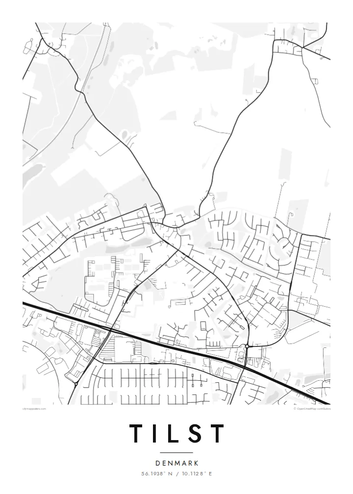
Residential areas are built around short dead-end streets and loops, which form leaf-like clusters on the map and give the poster its distinctive rhythm.
Minimalist map poster · Denmark
56.1938° N / 10.1128° E
A suburban town on the western edge of Aarhus, with looping residential streets that give way to open Jutland fields.
One city, five moods
Tap a style to see it on the wall. Every style costs the same — printed, framed or as HD files.
 Actual pixels · 24 × 36″ print file
Print-sharp
This is a 100% crop of the real print file. Every poster — printed, framed or downloaded — is rendered on our servers at 300 DPI, up to 7,200 × 10,800 pixels, so even the smallest lanes stay crisp on a 24 × 36″ print.
On the wall


The map
Tilst lies on the western edge of Aarhus in Central Jutland, close enough to the city to count as a suburb but still bordered by farmland. The map shows a pattern typical of Danish suburban growth: residential neighbourhoods of curving streets, loops and cul-de-sacs, planned in stages and separated by green strips, footpaths and small open spaces.
Unlike a grid, the street network branches and closes on itself. Each neighbourhood has its own internal loop, joined to a few collector roads that lead toward the city centre in the east. To the west and north the houses stop and fields begin, so the map shows the exact point where the city meets the Jutland countryside.
A Tilst map poster works well for families who have settled here and know every path between the houses. It also suits people who grew up in the neighbourhood and moved away. The organic street shapes make an attractive, almost botanical design, and they look especially good in the Noir style, where the white lines stand out against a dark background.
Residential areas are built around short dead-end streets and loops, which form leaf-like clusters on the map and give the poster its distinctive rhythm.
Footpaths and strips of green space run between the housing areas, leaving soft gaps in the street pattern that keep the composition light.
Aarhus lies to the east and open fields to the west, so the frame can capture both the edge of the city and the start of rural Jutland.
Make it yours
Add a date, a name or a line of your own, switch style, size or orientation.
The free preview is low-resolution with a watermark. Prints and HD files are rendered at 300 DPI, up to 7,200 × 10,800 px, without a watermark.
Why Tilst
Suburban places are where many people actually live, raise children and build routines. A map of Tilst records that everyday world, with the walk to school or the loop around the block, in a form that deserves a frame.
Add your surname or the year you moved in to the title, adjust the subtitle and coordinates, and pick one of five styles. The $9 download covers six print sizes, each as a 300 DPI PNG and a print-ready PDF.
Order the Tilst poster| Print size | Resolution | Files |
|---|---|---|
| 30 × 40 cm11.8 × 15.7″ | 3,543 × 4,724 px | PNG · PDF |
| 29.7 × 42 cm (A3)11.7 × 16.5″ | 3,508 × 4,961 px | PNG · PDF |
| 42 × 59.4 cm (A2)16.5 × 23.4″ | 4,961 × 7,016 px | PNG · PDF |
| 45.7 × 61 cm18 × 24″ | 5,400 × 7,200 px | PNG · PDF |
| 50 × 70 cm19.7 × 27.6″ | 5,906 × 8,268 px | PNG · PDF |
| 61 × 91.4 cm24 × 36″ | 7,200 × 10,800 px | PNG · PDF |
For comparison, the free preview is 900 px wide, watermarked and meant for screens. The HD files have up to 8× the resolution in each direction and print cleanly at full poster size.
Pick a style at the top of the page, then choose Printed Poster — a size and, if you like, a frame — or Digital HD Files. Checkout takes one step, and your order page updates as soon as the payment goes through.
It is printed on premium 200 gsm matte paper in one of six sizes, from 30 × 40 cm to 24 × 36″. Printed posters start at $39, shipping included.
Yes. Choose a solid wood frame in black, white, natural oak or dark wood. It comes with shatterproof glazing and is ready to hang. Framed posters start at $99, shipping included.
Shipping is free to 60+ countries. Each poster is printed by the nearest of our print partners in 30+ countries and usually arrives in 3–7 business days. You can follow the status and tracking under My Orders. A few countries take 2–5 weeks, and where we don't ship yet, the site tells you before you pay.
Send us a photo within 14 days of delivery and we will reprint it for free or refund you.
Yes. In the editor on this page, change the title, the subtitle and the coordinates line to anything you like, and pick a style and size. Printed, framed and digital orders all use exactly your design.
For $9 you get 300 DPI PNG and print-ready PDF files in all six sizes, without a watermark, to print anywhere. Not sure yet? Download a free watermarked preview first.
Nearby
