The Karun River
Iran's longest river runs past the town as it comes out of the Zagros. Its meanders and the farmland along its banks give the composition its strongest line.
Minimalistik karta plakaty · Eýran
32.2458° N / 48.8132° E
A compact Khuzestan town beside the Karun River, where the plain begins to rise toward the Zagros foothills


Bir şäher, bäş keýp
Diwarda nähili görünjegini görmek üçin stile basyň. Ähli stiller bir bahadan — çap edilen, çarçuwaly ýa-da HD faýl görnüşinde.
 Hakyky pikseller · 24 × 36″ çap faýly
Çapda aýdyň
Bu hakyky çap faýlynyň 100% kesigi. Her poster — çap edilen, çarçuwaly ýa-da ýüklenen — serwerlerimizde 300 DPI, 7,200 × 10,800 piksele çenli işlenip taýýarlanýar, şonuň üçin iň kiçi köçeler hem 24 × 36″ çapda arassa görünýär.
Diwarda


Karta
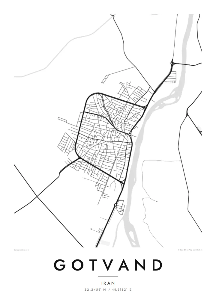
Gotvand sits in northern Khuzestan, where the flat farmland of southwestern Iran starts to fold into the first ridges of the Zagros. From above, the town is a small, dense cluster of streets on the plain. Irrigated fields and the line of the Karun River frame it, and the river is the feature that sets the direction of the whole map.
The Karun is Iran's longest river, and near Gotvand it leaves the mountains for the lowlands. Upstream, the Upper Gotvand Dam holds back one of the country's large reservoirs. Built for hydropower and water storage, it has been debated for years over salt deposits in the reservoir area. That puts the town at a point where a major river meets major engineering.
A Gotvand map poster keeps things plain: the grid of residential lanes, the roads heading out toward Shushtar and the dam, and the river's curve set against empty space. In black and white, the contrast between the settled plain and the rougher ground to the north comes through clearly. The result is a quiet, readable picture of a town shaped by water.
Iran's longest river runs past the town as it comes out of the Zagros. Its meanders and the farmland along its banks give the composition its strongest line.
North of the town, a large rockfill dam turns the Karun into a long reservoir. It is one of the best-known water projects in Khuzestan.
South of Gotvand the land lies flat and farmed. To the north the relief starts to break into ridges, so the map shows two landscapes meeting.
Özüňiziňki ediň
Sene, at ýa-da öz setiriňizi goşuň, stili, ölçegi ýa-da ugry üýtgediň.
Mugt deslapky görnüş pes durulykda we suw belgili. Çaplar we HD faýllar suw belgisiz, 300 DPI, 7,200 × 10,800 px çenli işlenip taýýarlanýar.
Näme üçin Gotvand
People who grew up in Gotvand, or whose families farmed along the Karun, often want something that shows home as it actually lies on the land. This map does that simply, with the river, the fields and the town between them.
You can set the title, subtitle and coordinates line to mark a family name, a year or the exact spot of a house. Then pick one of five styles: Classic black & white, Noir, Paper, Blueprint or Sand.
Gotvand posterini sargyt ediň| Çap ölçegi | Çözgüt | Faýllar |
|---|---|---|
| 30 × 40 cm (11.8 × 15.7″) | 3,543 × 4,724 px | PNG · PDF |
| 29.7 × 42 cm (A3, 11.7 × 16.5″) | 3,508 × 4,961 px | PNG · PDF |
| 42 × 59.4 cm (A2, 16.5 × 23.4″) | 4,961 × 7,016 px | PNG · PDF |
| 45.7 × 61 cm (18 × 24″) | 5,400 × 7,200 px | PNG · PDF |
| 50 × 70 cm (19.7 × 27.6″) | 5,906 × 8,268 px | PNG · PDF |
| 61 × 91.4 cm (24 × 36″) | 7,200 × 10,800 px | PNG · PDF |
Deňeşdirmek üçin: mugt nusga 900 px giňlikde, suw belgili we ekranlar üçin niýetlenen. HD faýllaryň çözgüdi her tarapa 8 esse çenli ýokary we doly plakat ölçeginde arassa çap edilýär.
Sahypanyň ýokarsyndan stili saýlaň, soňra Çap edilen Poster — ölçegini we isleseňiz çarçuwasyny — ýa-da Sanly HD Faýllary saýlaň. Töleg bir ädimde amala aşyrylýar, tölegiňiz geçen dessine sargyt sahypaňyz täzelenýär.
Ol ýokary hilli 200 gsm mat kagyza, alty ölçegiň birinde, 30 × 40 sm-den 24 × 36″-a çenli çap edilýär. Çap edilen posterler {printFrom}-dan başlaýar, eltip bermek bahasy girýär.
Hawa. Gara, ak, tebigy dub ýa-da garaňky agaç reňkinde tutuş agaç çarçuwany saýlaň. Ol döwülmeýän aýna bilen gelýär we asmaga taýýar. Çarçuwaly posterler {framedFrom}-dan başlaýar, eltip bermek bahasy girýär.
Eltip bermek dünýäniň ähli ýerinde mugt. Her poster 30-dan gowrak ýurtdaky çap hyzmatdaşlarymyzyň iň ýakynynda çap edilýär we adatça 3–7 iş gününde gelýär. Ýagdaýyny we yzarlamany Sargytlarym bölüminde görüp bilersiňiz.
Eltilenden soň 14 günüň dowamynda bize surat iberiň, biz ony mugt gaýtadan çap ederis ýa-da puluňyzy yzyna gaýtararys.
Hawa. Bu sahypadaky redaktorda ady, kiçi ady we koordinatlar setirini islän zadyňyza üýtgediň, soňra stil we ölçeg saýlaň. Çap edilen, çarçuwaly we sanly sargytlaryň ählisi siziň dizaýnyňyzy takyk ulanýar.
$9 üçin ähli alty ölçegde, suw belgisiz, islendik ýerde çap edip bolýan 300 DPI PNG we çap etmäge taýyn PDF faýllaryny alýarsyňyz. Entek gutarnykly karara gelmediňizmi? Ilki mugt, suw belgili deslapky görnüşi göçürip alyň.
Golaýda
