Congtai Park
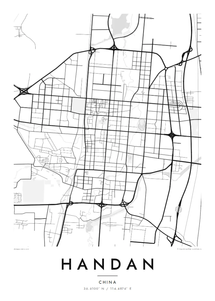
A large park with a lake near the city centre, built around an old terrace linked to the Zhao kings. On the map it forms an open, rounded shape among the rectangular blocks.
Minimalistik karta plakaty · Hytaý
36.6100° N / 114.4876° E
A broad, regular grid on the North China Plain, crossed by the Fuyang River below the Taihang foothills


Bir şäher, bäş keýp
Diwarda nähili görünjegini görmek üçin stile basyň. Ähli stiller bir bahadan — çap edilen, çarçuwaly ýa-da HD faýl görnüşinde.
 Hakyky pikseller · 24 × 36″ çap faýly
Çapda aýdyň
Bu hakyky çap faýlynyň 100% kesigi. Her poster — çap edilen, çarçuwaly ýa-da ýüklenen — serwerlerimizde 300 DPI, 7,200 × 10,800 piksele çenli işlenip taýýarlanýar, şonuň üçin iň kiçi köçeler hem 24 × 36″ çapda arassa görünýär.
Diwarda


Karta
Handan is one of China's oldest cities. It served as the capital of the State of Zhao during the Warring States period and has kept the same name for close to three thousand years. It is often called the home of Chinese idioms, since a large number of classical four-character sayings, among them the story of learning to walk in Handan, trace their origins to events set here.
The modern city is laid out on the flat North China Plain, with the foothills of the Taihang Mountains rising to the west. On the map it reads as a broad, regular grid of wide avenues and large blocks, crossed by the winding Fuyang River and by the main north–south railway, with industrial districts spread across its outer areas.
Near the centre, Congtai Park surrounds a lake and the raised terrace traditionally associated with King Wuling of Zhao. A Handan map poster sets this green space and the curve of the river against the rigour of the street grid, producing a composition that is ordered yet not mechanical, and that reflects both the ancient capital and the working industrial city.
A large park with a lake near the city centre, built around an old terrace linked to the Zhao kings. On the map it forms an open, rounded shape among the rectangular blocks.
The river winds through Handan in gentle curves, the main natural line crossing an otherwise strictly rectilinear city.
Wide avenues running north–south and east–west divide Handan into large, even blocks, a pattern that gives the poster its calm and measured rhythm.
Özüňiziňki ediň
Sene, at ýa-da öz setiriňizi goşuň, stili, ölçegi ýa-da ugry üýtgediň.
Mugt deslapky görnüş pes durulykda we suw belgili. Çaplar we HD faýllar suw belgisiz, 300 DPI, 7,200 × 10,800 px çenli işlenip taýýarlanýar.
Näme üçin Handan
Handan appeals to people with family roots in southern Hebei, and to anyone drawn to cities where ancient history lies under a modern plan. Its orderly grid and single winding river make a clean, graphic image that works in both traditional and contemporary interiors.
Add your own title, perhaps a favourite idiom or a family name, and a date or place in the subtitle, with an editable coordinates line. Five styles are available: Classic black & white, Noir, Paper, Blueprint and Sand.
Handan posterini sargyt ediň| Çap ölçegi | Çözgüt | Faýllar |
|---|---|---|
| 30 × 40 cm (11.8 × 15.7″) | 3,543 × 4,724 px | PNG · PDF |
| 29.7 × 42 cm (A3, 11.7 × 16.5″) | 3,508 × 4,961 px | PNG · PDF |
| 42 × 59.4 cm (A2, 16.5 × 23.4″) | 4,961 × 7,016 px | PNG · PDF |
| 45.7 × 61 cm (18 × 24″) | 5,400 × 7,200 px | PNG · PDF |
| 50 × 70 cm (19.7 × 27.6″) | 5,906 × 8,268 px | PNG · PDF |
| 61 × 91.4 cm (24 × 36″) | 7,200 × 10,800 px | PNG · PDF |
Deňeşdirmek üçin: mugt nusga 900 px giňlikde, suw belgili we ekranlar üçin niýetlenen. HD faýllaryň çözgüdi her tarapa 8 esse çenli ýokary we doly plakat ölçeginde arassa çap edilýär.
Sahypanyň ýokarsyndan stili saýlaň, soňra Çap edilen Poster — ölçegini we isleseňiz çarçuwasyny — ýa-da Sanly HD Faýllary saýlaň. Töleg bir ädimde amala aşyrylýar, tölegiňiz geçen dessine sargyt sahypaňyz täzelenýär.
Ol ýokary hilli 200 gsm mat kagyza, alty ölçegiň birinde, 30 × 40 sm-den 24 × 36″-a çenli çap edilýär. Çap edilen posterler {printFrom}-dan başlaýar, eltip bermek bahasy girýär.
Hawa. Gara, ak, tebigy dub ýa-da garaňky agaç reňkinde tutuş agaç çarçuwany saýlaň. Ol döwülmeýän aýna bilen gelýär we asmaga taýýar. Çarçuwaly posterler {framedFrom}-dan başlaýar, eltip bermek bahasy girýär.
Eltip bermek dünýäniň ähli ýerinde mugt. Her poster 30-dan gowrak ýurtdaky çap hyzmatdaşlarymyzyň iň ýakynynda çap edilýär we adatça 3–7 iş gününde gelýär. Ýagdaýyny we yzarlamany Sargytlarym bölüminde görüp bilersiňiz.
Eltilenden soň 14 günüň dowamynda bize surat iberiň, biz ony mugt gaýtadan çap ederis ýa-da puluňyzy yzyna gaýtararys.
Hawa. Bu sahypadaky redaktorda ady, kiçi ady we koordinatlar setirini islän zadyňyza üýtgediň, soňra stil we ölçeg saýlaň. Çap edilen, çarçuwaly we sanly sargytlaryň ählisi siziň dizaýnyňyzy takyk ulanýar.
$9 üçin ähli alty ölçegde, suw belgisiz, islendik ýerde çap edip bolýan 300 DPI PNG we çap etmäge taýyn PDF faýllaryny alýarsyňyz. Entek gutarnykly karara gelmediňizmi? Ilki mugt, suw belgili deslapky görnüşi göçürip alyň.
Golaýda
