Suomenlinna sea fortress
Built in the eighteenth century across several linked islands at the harbour entrance, its angular bastions and irregular walls form one of the most distinctive outlines on the whole map.
Minimalistik karta plakaty · Finlýandiýa
60.1695° N / 24.9354° E
A granite peninsula that breaks into bays and islands, with a compact grid at its tip and sea on three sides


Bir şäher, bäş keýp
Diwarda nähili görünjegini görmek üçin stile basyň. Ähli stiller bir bahadan — çap edilen, çarçuwaly ýa-da HD faýl görnüşinde.
 Hakyky pikseller · 24 × 36″ çap faýly
Çapda aýdyň
Bu hakyky çap faýlynyň 100% kesigi. Her poster — çap edilen, çarçuwaly ýa-da ýüklenen — serwerlerimizde 300 DPI, 7,200 × 10,800 piksele çenli işlenip taýýarlanýar, şonuň üçin iň kiçi köçeler hem 24 × 36″ çapda arassa görünýär.
Diwarda


Karta
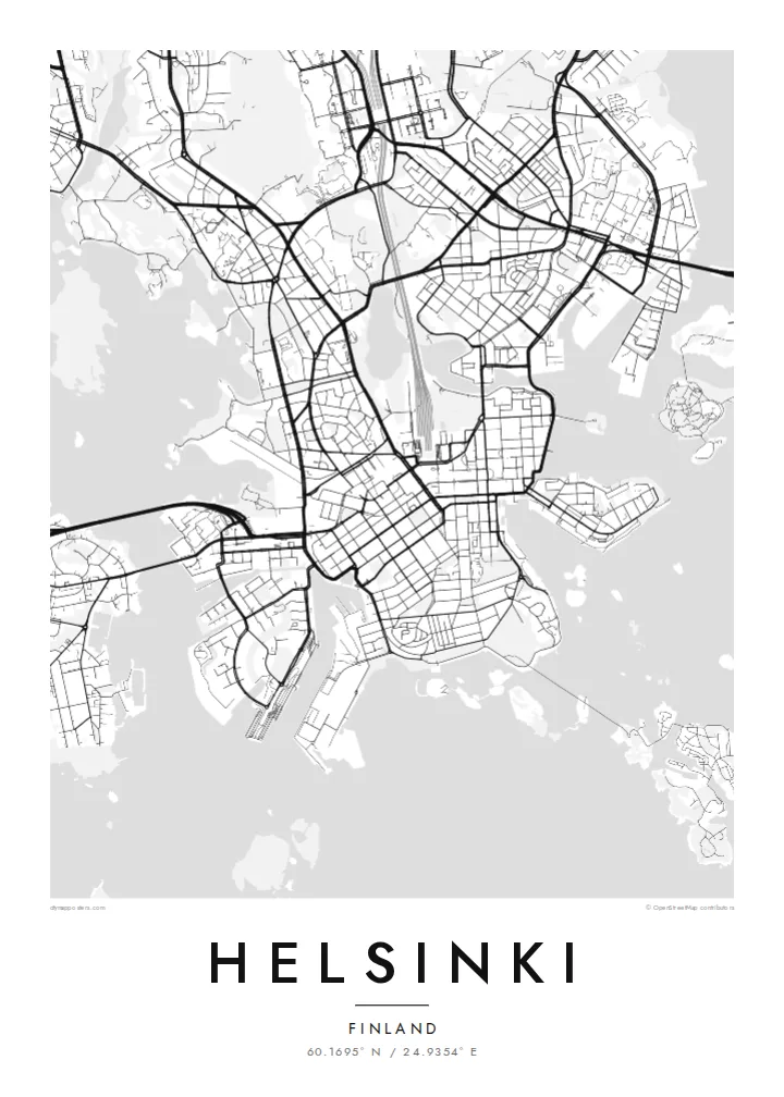
Helsinki sits on a peninsula that pushes into the Gulf of Finland, and from above its coastline matters most. The land breaks into coves, headlands and more than three hundred islands, so the city carries on past the point where the streets stop. Inland the pattern loosens into leafy districts and a long strip of forest, the Central Park, which runs north almost unbroken from Töölö Bay towards the city's edge.
The centre is orderly. After Helsinki was named capital in 1812, the architect Carl Ludvig Engel laid out a neoclassical core around Senate Square. The Esplanadi park strip still runs west from the market harbour as straight as a ruler. Around it, blocks of stone apartment buildings form a tight grid that reads cleanly in black and white. Rail yards and the long curve of the harbour break it up.
A Helsinki map poster shows this balance of order and irregularity: a precise centre, a coastline with almost no straight lines, and water in every gap. Offshore, the island fortress of Suomenlinna, a UNESCO World Heritage Site, spreads across a cluster of connected islets at the harbour mouth. Ferries, bridges and causeways join the rest together, and each one leaves a thin line on the page.
Built in the eighteenth century across several linked islands at the harbour entrance, its angular bastions and irregular walls form one of the most distinctive outlines on the whole map.
Senate Square and the Esplanadi park avenue sit just back from the South Harbour. They give the densest streets a clear, symmetrical anchor that stands out at every print size.
A band of forest about ten kilometres long runs north from the inner city. It leaves a wide, pale ribbon between the residential districts on either side.
Özüňiziňki ediň
Sene, at ýa-da öz setiriňizi goşuň, stili, ölçegi ýa-da ugry üýtgediň.
Mugt deslapky görnüş pes durulykda we suw belgili. Çaplar we HD faýllar suw belgisiz, 300 DPI, 7,200 × 10,800 px çenli işlenip taýýarlanýar.
Näme üçin Helsinki
People hang Helsinki for a flat near Töölö, summers on the islands, or an exchange year that turned into something longer. The map holds all of it at once: the harbour, the grid and the sea. Add a title, a date or a line of coordinates to mark which chapter it belongs to.
The coastline works especially well in Noir, where the water turns dark and the islands look like scattered light, or in Blueprint for a cooler, technical look. Classic black & white, Paper and Sand are available too. Download the HD files for $9 or order a matte print, framed if you like.
Helsinki posterini sargyt ediň| Çap ölçegi | Çözgüt | Faýllar |
|---|---|---|
| 30 × 40 cm (11.8 × 15.7″) | 3,543 × 4,724 px | PNG · PDF |
| 29.7 × 42 cm (A3, 11.7 × 16.5″) | 3,508 × 4,961 px | PNG · PDF |
| 42 × 59.4 cm (A2, 16.5 × 23.4″) | 4,961 × 7,016 px | PNG · PDF |
| 45.7 × 61 cm (18 × 24″) | 5,400 × 7,200 px | PNG · PDF |
| 50 × 70 cm (19.7 × 27.6″) | 5,906 × 8,268 px | PNG · PDF |
| 61 × 91.4 cm (24 × 36″) | 7,200 × 10,800 px | PNG · PDF |
Deňeşdirmek üçin: mugt nusga 900 px giňlikde, suw belgili we ekranlar üçin niýetlenen. HD faýllaryň çözgüdi her tarapa 8 esse çenli ýokary we doly plakat ölçeginde arassa çap edilýär.
Sahypanyň ýokarsyndan stili saýlaň, soňra Çap edilen Poster — ölçegini we isleseňiz çarçuwasyny — ýa-da Sanly HD Faýllary saýlaň. Töleg bir ädimde amala aşyrylýar, tölegiňiz geçen dessine sargyt sahypaňyz täzelenýär.
Ol ýokary hilli 200 gsm mat kagyza, alty ölçegiň birinde, 30 × 40 sm-den 24 × 36″-a çenli çap edilýär. Çap edilen posterler $39-dan başlaýar, eltip bermek bahasy girýär.
Hawa. Gara, ak, tebigy dub ýa-da garaňky agaç reňkinde tutuş agaç çarçuwany saýlaň. Ol döwülmeýän aýna bilen gelýär we asmaga taýýar. Çarçuwaly posterler $99-dan başlaýar, eltip bermek bahasy girýär.
Eltip getirmek dünýäniň hemme ýerine mugt. Her plakat 30-dan gowrak ýurtdaky çap hyzmatdaşlarymyzyň iň ýakynynda çap edilýär we adatça 3–7 iş gününde gelýär. Ýagdaýyny we yzarlaýyş maglumatyny «Meniň sargytlarym» bölüminde görüp bilersiňiz. Käbir ýurtlara 2–5 hepde gerek bolýar, entek eltip bermeýän ýurtlarymyz üçin bolsa sagdyn töleginden öň sahypada habar berilýär.
Eltilenden soň 14 günüň dowamynda bize surat iberiň, biz ony mugt gaýtadan çap ederis ýa-da puluňyzy yzyna gaýtararys.
Hawa. Bu sahypadaky redaktorda ady, kiçi ady we koordinatlar setirini islän zadyňyza üýtgediň, soňra stil we ölçeg saýlaň. Çap edilen, çarçuwaly we sanly sargytlaryň ählisi siziň dizaýnyňyzy takyk ulanýar.
$9 üçin ähli alty ölçegde, suw belgisiz, islendik ýerde çap edip bolýan 300 DPI PNG we çap etmäge taýyn PDF faýllaryny alýarsyňyz. Entek gutarnykly karara gelmediňizmi? Ilki mugt, suw belgili deslapky görnüşi göçürip alyň.
Golaýda
