Rosetta branch
The western arm of the Nile runs past the town in a wide, smooth curve. It is the dominant feature of the composition and sets the town's orientation.
Minimalistik karta plakaty · Müsür
31.2944° N / 30.5225° E
A delta town on the Rosetta branch of the Nile, surrounded by a fine grid of canals and fields




Bir şäher, bäş keýp
Diwarda nähili görünjegini görmek üçin stile basyň. Ähli stiller bir bahadan — çap edilen, çarçuwaly ýa-da HD faýl görnüşinde.
 Hakyky pikseller · 24 × 36″ çap faýly
Çapda aýdyň
Bu hakyky çap faýlynyň 100% kesigi. Her poster — çap edilen, çarçuwaly ýa-da ýüklenen — serwerlerimizde 300 DPI, 7,200 × 10,800 piksele çenli işlenip taýýarlanýar, şonuň üçin iň kiçi köçeler hem 24 × 36″ çapda arassa görünýär.
Diwarda


Karta
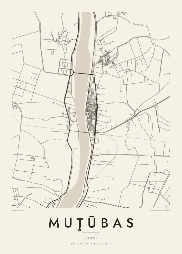
Muţūbas sits in Kafr el-Sheikh Governorate on the eastern bank of the Rosetta branch, the western of the two arms the Nile splits into before it reaches the Mediterranean. The river is the strongest line on the map. It is a broad, gently curving band, and the town's compact centre presses up against it, with the densest streets closest to the water.
Away from the river, the land opens into the flat, intensively farmed delta. Irrigation canals and drainage channels cut the fields into long narrow strips, and small villages sit along the embankments. The town of Rosetta lies a short distance downstream near the sea, and the whole area is a lowland where water, silt and farming have shaped the land for thousands of years.
A Muţūbas map poster captures a landscape that looks almost woven when seen from above. The river's single sweep contrasts with hundreds of straight field edges, and the town is the one dense knot among them. For anyone with roots in this part of the northern delta, it shows home at the scale where the Nile's influence is most obvious.
The western arm of the Nile runs past the town in a wide, smooth curve. It is the dominant feature of the composition and sets the town's orientation.
Irrigation and drainage channels divide the surrounding fields into long parallel strips, creating dense linear texture typical of the northern Nile Delta.
The oldest and tightest streets cluster close to the riverbank, where the pattern of the built-up area is at its most intricate.
Özüňiziňki ediň
Sene, at ýa-da öz setiriňizi goşuň, stili, ölçegi ýa-da ugry üýtgediň.
Mugt deslapky görnüş pes durulykda we suw belgili. Çaplar we HD faýllar suw belgisiz, 300 DPI, 7,200 × 10,800 px çenli işlenip taýýarlanýar.
Näme üçin Muţūbas
This map is for people who left the delta for Cairo, Alexandria or further abroad and want the river of home on the wall. It also suits anyone drawn to the geometry of irrigated farmland, where every line has a practical purpose.
The title, subtitle and coordinates can all be personalised, for example with a family name in Arabic transliteration or a meaningful year. There are five styles: Classic black & white, Noir, Paper, Blueprint and Sand. A free 900 px watermarked preview lets you check the framing before buying.
Muţūbas posterini sargyt ediň| Çap ölçegi | Çözgüt | Faýllar |
|---|---|---|
| 30 × 40 cm (11.8 × 15.7″) | 3,543 × 4,724 px | PNG · PDF |
| 29.7 × 42 cm (A3, 11.7 × 16.5″) | 3,508 × 4,961 px | PNG · PDF |
| 42 × 59.4 cm (A2, 16.5 × 23.4″) | 4,961 × 7,016 px | PNG · PDF |
| 45.7 × 61 cm (18 × 24″) | 5,400 × 7,200 px | PNG · PDF |
| 50 × 70 cm (19.7 × 27.6″) | 5,906 × 8,268 px | PNG · PDF |
| 61 × 91.4 cm (24 × 36″) | 7,200 × 10,800 px | PNG · PDF |
Deňeşdirmek üçin: mugt nusga 900 px giňlikde, suw belgili we ekranlar üçin niýetlenen. HD faýllaryň çözgüdi her tarapa 8 esse çenli ýokary we doly plakat ölçeginde arassa çap edilýär.
Sahypanyň ýokarsyndan stili saýlaň, soňra Çap edilen Poster — ölçegini we isleseňiz çarçuwasyny — ýa-da Sanly HD Faýllary saýlaň. Töleg bir ädimde amala aşyrylýar, tölegiňiz geçen dessine sargyt sahypaňyz täzelenýär.
Ol ýokary hilli 200 gsm mat kagyza, alty ölçegiň birinde, 30 × 40 sm-den 24 × 36″-a çenli çap edilýär. Çap edilen posterler {printFrom}-dan başlaýar, eltip bermek bahasy girýär.
Hawa. Gara, ak, tebigy dub ýa-da garaňky agaç reňkinde tutuş agaç çarçuwany saýlaň. Ol döwülmeýän aýna bilen gelýär we asmaga taýýar. Çarçuwaly posterler {framedFrom}-dan başlaýar, eltip bermek bahasy girýär.
Eltip bermek dünýäniň ähli ýerinde mugt. Her poster 30-dan gowrak ýurtdaky çap hyzmatdaşlarymyzyň iň ýakynynda çap edilýär we adatça 3–7 iş gününde gelýär. Ýagdaýyny we yzarlamany Sargytlarym bölüminde görüp bilersiňiz.
Eltilenden soň 14 günüň dowamynda bize surat iberiň, biz ony mugt gaýtadan çap ederis ýa-da puluňyzy yzyna gaýtararys.
Hawa. Bu sahypadaky redaktorda ady, kiçi ady we koordinatlar setirini islän zadyňyza üýtgediň, soňra stil we ölçeg saýlaň. Çap edilen, çarçuwaly we sanly sargytlaryň ählisi siziň dizaýnyňyzy takyk ulanýar.
$9 üçin ähli alty ölçegde, suw belgisiz, islendik ýerde çap edip bolýan 300 DPI PNG we çap etmäge taýyn PDF faýllaryny alýarsyňyz. Entek gutarnykly karara gelmediňizmi? Ilki mugt, suw belgili deslapky görnüşi göçürip alyň.
