Wakamiya-ōji
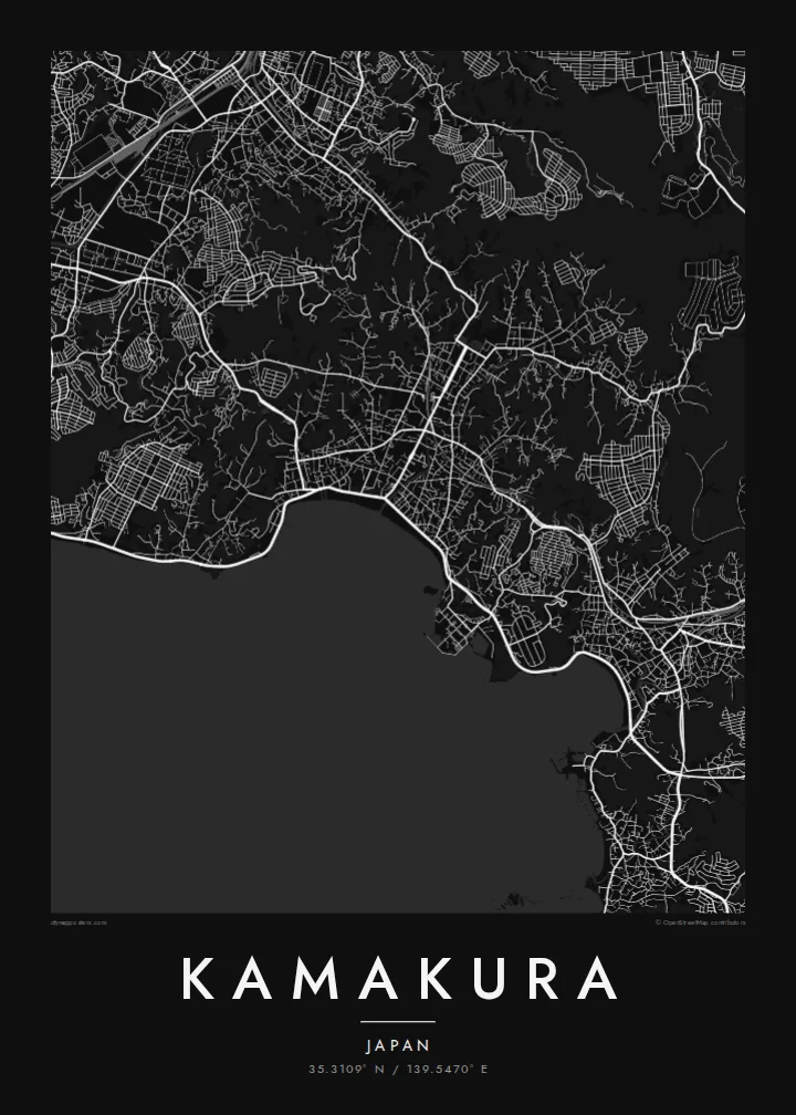
The straight processional avenue runs from the Hachimangū shrine to the sea, a single decisive line through the centre that gives the whole map its orientation.
Pōhita mape faigofie · Japan
35.3109° N / 139.5470° E
A former shogun's capital enclosed by wooded hills on three sides, opening south onto the curve of Sagami Bay.



Taone e tahi, lagona e lima
Pa'i se ata ke va'ai ai i luga o te pā. E tutusa te tau o ata uma — i lomiga, fakapipi'i i faleata, pe ko faila HD.
 Pixels mo'i · Faila lomiga 24 × 36″
Manino mo te lomiga
Ko se kupega 100% mai te faila lomiga mo'i. Poster uma — pe lomiina, fakapipi'i i faleata, pe download-ina — e fakaatagia i luga o a matou setula i te 300 DPI, e oo atu ki te 7,200 × 10,800 pixels, ina ia mautinoa e ma'ai pea auala tuai foki i luga o se lomiga 24 × 36″.
I luga o te pa


Te mape
Kamakura was the seat of Japan's first shogunate from the late twelfth century, and it was chosen partly for its shape. Hills close in on the north, east and west, while the south opens onto the sea, a natural fortress reached through narrow cuttings in the ridges. On a map that bowl is still easy to read: dense streets in the lowland, green folds all around.
At the centre runs Wakamiya-ōji, a straight avenue laid out from Tsurugaoka Hachimangū shrine down to the beach at Yuigahama. It is the clearest axis in the city and the spine around which everything else falls into place. To the west, in the Hase district, the Great Buddha of Kōtoku-in sits in the open air, a bronze figure cast in the thirteenth century.
A Kamakura map poster holds a remarkable amount in one frame: the ceremonial avenue, the beach curving toward the headland, temple grounds tucked into valleys and lanes that wind into the hills. It is a favourite with people who have visited from Tokyo or Yokohama, and a meaningful map for anyone interested in Japanese history.
The straight processional avenue runs from the Hachimangū shrine to the sea, a single decisive line through the centre that gives the whole map its orientation.
The beach forms a smooth arc along Sagami Bay at the southern edge of the city, a clean boundary between dense streets and open water.
Temples and shrines sit in narrow valleys cut into the surrounding hills, visible on the map as small pockets of paths and buildings reached by winding lanes.
Fai mo koe
Fakaopoopo he aho, he igoa pe he upu a koe, hui te faiga, te lahi pe te tūlaga.
Ko te va'aiga e leai se totogi e maualalo tona resolution ma iai se fakailoga vai. E fakaatagia lomiga ma faila HD i te 300 DPI, e oo atu ki te 7,200 × 10,800 px, e aunoa ma se fakailoga vai.
Aiheā Kamakura
Kamakura is often a day of quiet memories: the walk to the Great Buddha, the beach at sunset, a temple garden in the hills. A map captures the whole day in one image, and the city's shape makes it recognisable at a glance.
Personalise the title, subtitle and coordinates line, for example with the date of a trip or a honeymoon, and choose one of five styles: Classic black & white, Noir, Paper, Blueprint or Sand. Paper suits the historic streets especially well.
Oka te poster Kamakura| Lahi o te lomiga | Manino | Faila |
|---|---|---|
| 30 × 40 cm (11.8 × 15.7″) | 3,543 × 4,724 px | PNG · PDF |
| 29.7 × 42 cm (A3, 11.7 × 16.5″) | 3,508 × 4,961 px | PNG · PDF |
| 42 × 59.4 cm (A2, 16.5 × 23.4″) | 4,961 × 7,016 px | PNG · PDF |
| 45.7 × 61 cm (18 × 24″) | 5,400 × 7,200 px | PNG · PDF |
| 50 × 70 cm (19.7 × 27.6″) | 5,906 × 8,268 px | PNG · PDF |
| 61 × 91.4 cm (24 × 36″) | 7,200 × 10,800 px | PNG · PDF |
Mo te fakatatau, ko te fakaakoakoga e hē totogi e 900 px te lautele, e ihi te fakailoga ma mo te lau komipiuta. Ko nā faila HD e oko ki te 8× te manino i itū taki tahi ma e lomia lelei i te lahi kātoa o te pōhita.
Filifili se ata i te pito i luga o te itulau, ona filifili lea o te Poster Lomiina — se lapoa ma, ka manako ai koe, se faleata — pe ko Faila HD Fakaonaonaina. E tasi te laasaga o te ōkaina, ma ka fakafou loa lau itulau ōkaina pe a mae'a te totogi.
E lomiina i luga o se pepa matte kaliki maualuga e 200 gsm, i se tasi o ni lapoa e ono, mai le 30 × 40 cm ki te 24 × 36″. E kamata te tau o poster lomiina mai le $39, aofia ai te uta.
Ioe. Filifili se faleata lakau malō i te lanu uli, tea, oki masani pe lakau pouli. E aumai fakatasi mo se tioata e le gagamu ma ua sauni ke tautau. E kamata te tau o poster fakapipi'i i se faleata mai le $99, aofia ai te uta.
E leai se totogi o te ave i te lalolagi katoa. Ko te pepa ata taki tasi e lomi e te hoa lomi e latalata mai ki a matou i atunuku e 30+, ma e masani ona aulia i aso galuega e 3–7. E mafai ke e mulimuli i te tulaga ma te ala o tau poloaiga i lalo o Aku Poloaiga. E nai atunuku e 2–5 vaiaso te umi, ma i te mea e le i ave ai matou, e fakailoa atu e te initeneti a e le i totogi koe.
Auina mai se ata pikitia i loto o te 14 aso mai te taimi na oo mai ai, ka toe lomiina e matou e leai se totogi pe toe totogi atu lau tupe.
Ioe. I te mea fakasa'o i luga o lenei itulau, sui te ulutala, te ulutala lalo ma te laina fakamaoniga tulaga ki so se mea e manako ai koe, ona filifili lea o se ata ma se lapoa. Okaina lomiina, fakapipi'i i faleata, ma fakaonaonaina e fakaaogā uma i tau ata tonu.
Mo le $9 e maua e koe ni faila PNG 300 DPI ma PDF sauni-mo-lomiga i lapoa e ono uma, e aunoa ma se fakailoga vai, ke lomiina i so se mea. E le'i mautinoa? Download muamua se va'aiga fakailoga vai e leai se totogi.
Latalata
