Huai River
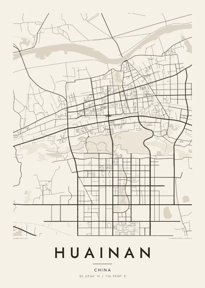
The river runs along the northern edge of the city, broad and slowly curving. Bridges and embankments mark where the urban area meets the water.
Pōsitā mape sitaila faingofua · Siaina
32.6264° N / 116.9969° E
A coal city stretched along the southern bank of the Huai River, its districts strung out between the water and low hills.




Kolo ʻe taha, ongoʻi ʻe nima
Tuki ha sitaile ke sio ai 'i ho holisi. 'Oku tatau pē 'a e totongi 'o e sitaile kotoa pē — tā pepa, fa'o, pe ko e fa'ile HD.
 Pika mo'oni · fa'ile tā 24 × 36″
Mahino ke paaki
Ko ha konga 100% eni mei he fa'ile tā mo'oni. Ko e posita kotoa pē — tā pepa, fa'o, pe download — 'oku ngaohi 'i he'emau sāvā 'i he 300 DPI, 'o a'u ki he 7,200 × 10,800 pika, koe'uhi ke mahino lelei 'a e ngaahi hala si'isi'i taha 'i ha tā 24 × 36″.
'I he pā


Ko e mape
Huainan grew in the twentieth century as a coal-mining city in central Anhui, and its map reflects that origin. It did not spread from a single old centre. Instead it developed around separate mining areas along the southern bank of the Huai River, so its districts stretch out in a long east–west line with open land and water between them.
The Huai River is the clearest line on the map, a wide, curving waterway that marks the traditional division between northern and southern China. Mining subsidence has created lakes and wetlands in several parts of the area. Some have been turned into parks, adding irregular open shapes to the street pattern.
The city's name is linked to Liu An, Prince of Huainan in the Han dynasty and compiler of the Huainanzi, and tradition credits the region with the invention of tofu. Nearby Bagong Mountain is associated with the Battle of the Fei River. A Huainan map poster shows a city defined by its river and its industry.
The river runs along the northern edge of the city, broad and slowly curving. Bridges and embankments mark where the urban area meets the water.
Separate urban districts line up from east to west, joined by long main roads. The map's elongated outline comes from mining history rather than a planned centre.
Lakes that formed over old mine workings appear as irregular open areas among the streets. Some are now landscaped, a distinctive feature of coal cities on the plain.
Ke ʻaʻau pē
Tānaki ha ʻaho, ha hingoa pe ha laine ʻaʻau, pea liliu ʻa e sitaila, saisi pe tuʻunga.
Ko e sio muʻa ta'etotongi 'oku ma'ulalo hono lelei pea 'oku ai hano fakaʻilonga vai. Ko e ngaahi tā mo e fa'ile HD 'oku ngaohi 'i he 300 DPI, 'o a'u ki he 7,200 × 10,800 px, ta'e ha fakaʻilonga vai.
Ko e hā ʻa Huainan
Huainan is hung by people who grew up with its mines, its river and its tofu dishes. For families who have lived there for generations, the map records a place that has changed a great deal and keeps changing.
Choose a title and subtitle, and keep or edit the coordinates line. Classic black & white, Noir, Paper, Blueprint and Sand are all available. The $9 digital files come in six sizes, and a free watermarked preview lets you check the framing first.
'Oda 'a e posita Huainan| Saisi paaki | Tuʻunga mahino | Ngaahi faile |
|---|---|---|
| 30 × 40 cm11.8 × 15.7″ | 3,543 × 4,724 px | PNG · PDF |
| 29.7 × 42 cm (A3)11.7 × 16.5″ | 3,508 × 4,961 px | PNG · PDF |
| 42 × 59.4 cm (A2)16.5 × 23.4″ | 4,961 × 7,016 px | PNG · PDF |
| 45.7 × 61 cm18 × 24″ | 5,400 × 7,200 px | PNG · PDF |
| 50 × 70 cm19.7 × 27.6″ | 5,906 × 8,268 px | PNG · PDF |
| 61 × 91.4 cm24 × 36″ | 7,200 × 10,800 px | PNG · PDF |
Ke fakafehoanaki, ko e sio fakamuʻa taʻetotongi ʻoku fālahi ʻaki ʻa e 900 px, ʻi ai hono fakaʻilonga-vai pea ki he ngaahi screen pē. ʻOku liunga 8 hono mahino ʻo e ngaahi faile HD ʻi he tafaʻaki kotoa pea ʻoku paaki lelei ʻi he saisi kakato ʻo e pōsitā.
Fili ha sitaile 'i he tumu'aki 'o e peesi, pea fili leva ha Posita Tā — ha lahi pea, kapau 'oku ke sai'ia, ha fa'o — pe ko e ngaahi Fa'ile Digital HD. Ko e Checkout ko e sitepu pē 'e taha, pea 'e fakafo'ou leva ho'o peesi 'oda 'i he taimi 'e a'u ai 'a e totongi.
'Oku tā ia 'i ha pepa matte 200 gsm mo'oni lelei taha, 'i ha taha 'o e ngaahi lahi 'e ono, mei he 30 × 40 cm ki he 24 × 36″. 'Oku kamata 'a e ngaahi posita kuo tā 'i he $39, kuo kau ai 'a e 'ave.
'Io. Fili ha fa'o 'akau mo'oni 'i he 'uli'uli, hina, oki fakanatula pe 'akau fu'u 'uli'uli. 'Oku fakataha mai mo ha sio'ata ta'emafesi pea kuo mateuteu ke tautau. 'Oku kamata 'a e ngaahi posita kuo fa'o 'i he $99, kuo kau ai 'a e 'ave.
ʻOku ʻataʻatā ʻa e fakaheka ki he ngaahi fonua ʻe 60+. ʻOku paaki ʻa e tuʻunga taki taha ʻe he tokotaha paaki ofi taha ʻo kitautolu ʻi he ngaahi fonua ʻe 30+, pea ʻoku maʻu angamaheni ia ʻi he ʻaho ngāue ʻe 3–7. ʻE lava ke ke muimui ki he tuʻunga mo e fakaʻilo ʻi he ʻOku ou Fakamaʻu. ʻOku toki ʻaho ʻe 2–5 uike ʻa e ngaahi fonua si'i, pea ʻi he ngaahi fonua ʻoku te teʻeki ke fakaheka ki ai, ʻoku fakahā atu ʻe he uepisaiti ʻi he ʻuluaki ʻo e totongi.
'Ave mai ha foto kiate kimautolu 'i he lolotonga 'o e 'aho 'e 14 mei he taimi na'e a'u mai ai, pea te mau toe tā ia ta'etotongi pe toe totongi atu 'a ho'o pa'anga.
'Io. 'I he editor 'i he peesi ni, liliu 'a e kaveinga, 'a e kaveinga si'i mo e laine fakafuofua ki ha me'a pē 'oku ke sai'ia ai, pea fili ha sitaile mo ha lahi. Ko e ngaahi 'oda tā, fa'o mo digital kotoa 'oku ngāue'aki ai pē ho'o fakatātā tofu pē.
'I he totongi 'e $9 'oku ke ma'u ai 'a e ngaahi fa'ile PNG 300 DPI mo e PDF kuo mateuteu ki he tā 'i he lahi 'e ono kotoa, 'ikai ha fakaʻilonga vai, ke tā ai 'i ha feitu'u pē. Te ke kei ta'epau? Download muʻa ha sio muʻa ta'etotongi 'oku ai hano fakaʻilonga vai.
Ofi mai
