Shire River
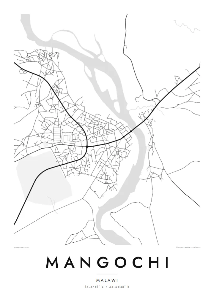
The Shire runs through the town, and its channel divides the map into two banks. A road bridge links them, making it the most important crossing in the area.
Pousita mape faigofie · Malawi
14.4781° S / 35.2645° E
A lakeside town at the southern tip of Lake Malawi, where the Shire River begins its course


Taone e tasi, lagona e lima
Pau te tapaki o se style ke lavea i luga i te puipui. E tutasi te tau o style takitasi — telotele mo faaki, e aunoa io me fai ki faila HD.
 Pixel tonu · faila lolomi 24 × 36″
Manino ki te lomiga
Tenei se 100% mai te faila lolomi tonu. Poster takitasi — telotele, faaki io me download — e faite i luga i a matou server i te 300 DPI, e oko atu ki 7,200 × 10,800 pixel, ko ala e maofio ei mo maiga vaega foliki i luga i te lolomi 24 × 36″.
I te pakitala


Te mape
Mangochi lies in southern Malawi, near the point where Lake Malawi narrows and empties into the Shire River. The town stretches along the river's banks, and its map is defined by that water: the channel running south, a road bridge crossing it, and the lakeshore just to the north with beaches and fishing villages along the coast.
Under the colonial administration the town was known as Fort Johnston, and it keeps several reminders of that period, including a clock tower commemorating Queen Victoria. The Lake Malawi Museum in the town tells the story of the lake, its fishing communities and its steamers.
A Mangochi map poster brings the river and the lake together in one frame. The town's streets sit on either side of the Shire, roads lead north along the lakeshore, and the open water gives the design a large calm space. It is a simple, strong composition shaped by geography.
The Shire runs through the town, and its channel divides the map into two banks. A road bridge links them, making it the most important crossing in the area.
Just north of the town, the southern tip of Lake Malawi opens out. The long shoreline and wide water give the top of the poster a clean, open surface.
The central streets, market and older colonial buildings lie close to the river. It is the densest part of the map, with roads branching out toward the lake and the south.
Fai ke fakatau ki a koe
Fakaopoopo se aso, se igoa io me se fuaiupu o koe, sui te sitaila, te lasi io me te tuuga.
Te preview fua e maulalo te malamalama kae iai se watermark. Poster telotele mo faila HD e faite i te 300 DPI, e oko atu ki 7,200 × 10,800 px, aunoa mo se watermark.
Kaia a Mangochi
For people from Mangochi, and for those who have spent time on the southern lakeshore, a map of the town where the lake becomes a river is both a personal memento and a striking piece of geography.
Add a title and subtitle of your choice and set the coordinates line to a home, a school or a stretch of beach. The poster is available in Classic black & white, Noir, Paper, Blueprint and Sand.
Otaina te poster Mangochi| Lasi o te lomiga | Manino | Faila |
|---|---|---|
| 30 × 40 cm11.8 × 15.7″ | 3,543 × 4,724 px | PNG · PDF |
| 29.7 × 42 cm (A3)11.7 × 16.5″ | 3,508 × 4,961 px | PNG · PDF |
| 42 × 59.4 cm (A2)16.5 × 23.4″ | 4,961 × 7,016 px | PNG · PDF |
| 45.7 × 61 cm18 × 24″ | 5,400 × 7,200 px | PNG · PDF |
| 50 × 70 cm19.7 × 27.6″ | 5,906 × 8,268 px | PNG · PDF |
| 61 × 91.4 cm24 × 36″ | 7,200 × 10,800 px | PNG · PDF |
Ke fakatusa, a te ata fakataitai fua e 900 px te lautele, mo te fakailoga kae mo lau lavea i luga i te komipiuta. A faila HD e oko ki te 8× te manino i itu katoa kae lomi faka‵lei i te lasi katoa o te pousita.
Filifili se style i te pito i luga o te itulau, kae filifili Poster Telotele — se lasi mo se faaki manafai e manako koe — io me Faila Digital HD. E tasi te sitepu mo te checkout, kae ka fakafou te itulau o tau ota i te taimi e mafai ei te totogi.
E telotele i luga o te pepa vali gali 200 gsm i se tasi mai lasi e ono, mai te 30 × 40 cm ki te 24 × 36″. E kamata te poster telotele mai i te $39, kae aofia ei te uta.
Ioe. Filifili se faaki lakau maoli i te kulokula, tea, oak maoli io me lakau pogisa. E oo mai ki tioata e se malepe kae toka ke tautau. E kamata te poster faaki mai i te $99, kae aofia ei te uta.
E tuku fua ki fenua e 60+. A poloaiga taki tasi e ta ne te tauhaga e latalata mai i a matou tauhaga ta i fenua e 30+, kae e masani o aunoa i aso galue e 3–7. E mafai o salasala te tulaga mo te sukesuke i lalo o Aku poloaiga. I nisi fenua e 2–5 vaiaso, kae i mea e seki tuku atu ei matou, e fakailoa atu e te mea tafaoga i mua o te totogi.
Auina mai se ata i loto i te 14 aso mai te taimi e oko ei kae ka toe telotele fua ne matou io me toe totogi atu tau tupe.
Ioe. I te editor i te itulau tenei, sui te ulutala, te ulutala lalo mo te laina o coordinate ki so se mea e manako koe, kae filifili se style mo se lasi. Oga telotele, faaki mo digital e faigana katoa i tau tusiga tonu.
Mo te $9 ka maua ne koe faila PNG 300 DPI mo PDF fakatoka lolomi i lasi e ono katoa, aunoa mo se watermark, ke lolomi i so se koga. E se mautinoa koe? Download muamua se preview fua e iai te watermark.
