Misumi West Port
A carefully engineered Meiji-era harbour of cut stone, with canals and quays, lies near the tip of the peninsula. It is one of the few ports of its era to survive largely intact.
Мінімалістичний постер-карта · Японія
32.6222° N / 130.6618° E
A coastal city at the root of the Uto Peninsula, facing two inland seas with a Meiji-era stone port at its western tip.



Одне місто, пʼять настроїв
Торкніться стилю, щоб побачити його на стіні. Усі стилі коштують однаково — у друку, в рамці чи як HD-файли.
 Реальні пікселі · файл друку 24 × 36″
Чіткість для друку
Це стовідсотковий фрагмент справжнього файлу для друку. Кожен постер — друкований, у рамці чи завантажений — рендериться на наших серверах із роздільністю 300 DPI, до 7,200 × 10,800 пікселів, тож навіть найдрібніші вулиці залишаються чіткими на друку 24 × 36″.
На стіні


Карта
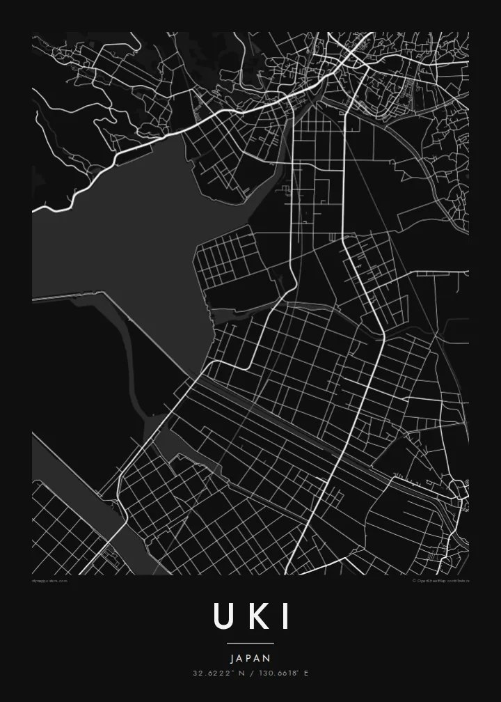
Uki sits in Kumamoto Prefecture at the base of the Uto Peninsula, which reaches west toward the Amakusa islands. On a map the city stretches along the peninsula. The Ariake Sea lies to the north and the Yatsushiro Sea to the south, and small towns and fishing harbours are strung along both shores. Hills run down the centre of the peninsula, with farmland and orchards on their lower slopes.
At the western end lies Misumi West Port, a stone harbour built in the late nineteenth century to Dutch designs. It is now a UNESCO World Heritage site as part of the Sites of Japan's Meiji Industrial Revolution. The Yatsushiro Sea off Uki's coast is also associated with the shiranui, a rare optical phenomenon of flickering lights on the water described in local tradition.
A Uki map poster traces a long, narrow city defined by its shorelines. Coastal roads follow the edge of the land, while a railway runs out along the peninsula toward the port. Smaller settlements appear as clusters where valleys meet the sea. The water surrounding almost every side gives the map a strong, clean silhouette.
A carefully engineered Meiji-era harbour of cut stone, with canals and quays, lies near the tip of the peninsula. It is one of the few ports of its era to survive largely intact.
The Ariake Sea and the Yatsushiro Sea border the city on opposite sides. On the map the peninsula becomes a long strip of land between two open bodies of water.
Hills run along the centre of the peninsula, with roads and small valleys branching toward the coasts. This inland ridge divides the city's northern and southern shores.
Зробіть його своїм
Додайте дату, імʼя чи власний підпис, змініть стиль, розмір або орієнтацію.
Безкоштовний перегляд — низької роздільності та з водяним знаком. Друк і HD-файли рендеряться з роздільністю 300 DPI, до 7,200 × 10,800 px, без водяного знака.
Чому Uki
Uki is a place of coastal drives, fishing harbours and evenings looking across the water toward Amakusa. A map of the peninsula keeps that geography in view for residents, for visitors and for anyone with family roots in Kumamoto.
Choose Classic black & white, Noir, Paper, Blueprint or Sand, and add your own title, subtitle and coordinates. The free preview lets you check the framing first. HD files cost $9, and printed posters can ship from partners in more than 30 countries.
Замовити постер «Uki»| Розмір друку | Роздільність | Файли |
|---|---|---|
| 30 × 40 cm (11.8 × 15.7″) | 3,543 × 4,724 px | PNG · PDF |
| 29.7 × 42 cm (A3, 11.7 × 16.5″) | 3,508 × 4,961 px | PNG · PDF |
| 42 × 59.4 cm (A2, 16.5 × 23.4″) | 4,961 × 7,016 px | PNG · PDF |
| 45.7 × 61 cm (18 × 24″) | 5,400 × 7,200 px | PNG · PDF |
| 50 × 70 cm (19.7 × 27.6″) | 5,906 × 8,268 px | PNG · PDF |
| 61 × 91.4 cm (24 × 36″) | 7,200 × 10,800 px | PNG · PDF |
Для порівняння: безкоштовне превʼю має ширину 900 px, водяний знак і призначене для екранів. HD-файли мають до 8× більшу роздільність у кожному вимірі й чисто друкуються в повному розмірі постера.
Оберіть стиль угорі сторінки, потім виберіть Друкований постер — розмір і, за бажанням, рамку — або Цифрові HD-файли. Оформлення замовлення займає один крок, і сторінка замовлення оновиться, щойно пройде оплата.
Його друкують на щільному матовому папері 200 г/м² в одному з шести розмірів — від 30 × 40 см до 24 × 36″. Друковані постери коштують від {printFrom}, доставка включена.
Так. Оберіть рамку з масиву дерева — чорну, білу, натуральний дуб або темне дерево. Вона йде з ударостійким склом і готова до розміщення на стіні. Постери в рамці коштують від {framedFrom}, доставка включена.
Доставка безкоштовна по всьому світу. Кожен постер друкує найближчий із наших друкарських партнерів у понад 30 країнах, і зазвичай він доходить за 3–7 робочих днів. Статус і трекінг можна відстежувати в розділі «Мої замовлення». До деяких країн доставка займає 2–5 тижнів, а якщо ми ще не доставляємо у ваш регіон, сайт повідомить про це до оплати.
Надішліть нам фото протягом 14 днів після доставки, і ми безкоштовно надрукуємо новий постер або повернемо кошти.
Так. У редакторі на цій сторінці змініть заголовок, підзаголовок і рядок з координатами на будь-які, а також оберіть стиль і розмір. Друковані, оформлені в рамку та цифрові замовлення повністю відповідають вашому дизайну.
За $9 ви отримаєте PNG і готові до друку PDF-файли з роздільністю 300 DPI у всіх шести розмірах, без водяного знака, для друку будь-де. Ще не впевнені? Спершу завантажте безкоштовний попередній перегляд із водяним знаком.
