Mountain backdrop
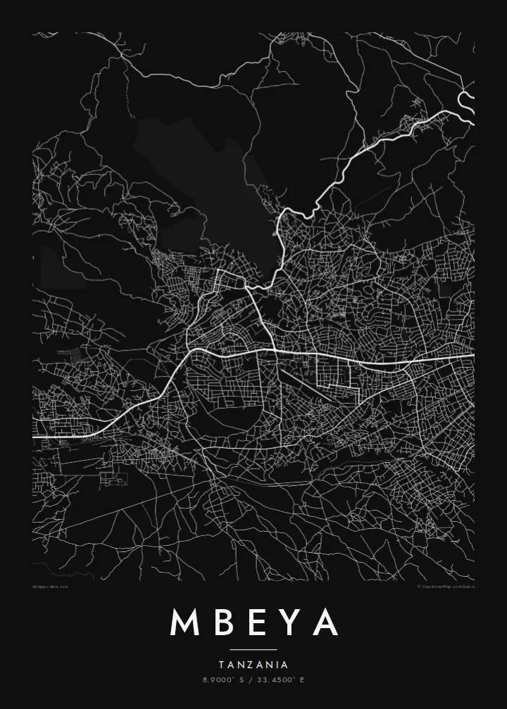
The Mbeya Range rises steeply beside the city. On the map its slopes appear as a broad open area that contrasts with the built-up valley floor.
سادہ نقشہ پوسٹر · تنزانیہ
8.9000° S / 33.4500° E
A highland city stretched along a valley floor, with steep mountain slopes rising close behind its northern edge.



ایک شہر، پانچ انداز
کوئی بھی اسٹائل منتخب کریں اور دیکھیں دیوار پر کیسا لگتا ہے۔ ہر اسٹائل کی قیمت ایک جیسی ہے — پرنٹ، فریم یا HD فائلز کے طور پر۔
 اصل پکسلز · 24 × 36″ پرنٹ فائل
پرنٹ جیسی واضح
یہ اصل پرنٹ فائل کا 100% کراپ ہے۔ ہر پوسٹر — چاہے پرنٹ ہو، فریم شدہ ہو یا ڈاؤن لوڈ کیا گیا ہو — ہمارے سرورز پر 300 DPI اور 7,200 × 10,800 پکسلز تک رینڈر کیا جاتا ہے، تاکہ 24 × 36″ پرنٹ پر بھی سب سے باریک گلیاں تک صاف نظر آئیں۔
دیوار پر


نقشہ
Mbeya lies high in the Southern Highlands of Tanzania, and the terrain sets the shape of the city. The built-up area extends along a valley at the foot of the Mbeya Range, so the plan is long rather than round, with roads following the lower slopes. On a map the mountain side appears largely empty, a clear boundary against the denser streets below.
The main highway and the TAZARA railway between Dar es Salaam and Zambia both pass through the area, and they form the strongest lines on the poster. Neighbourhoods branch off these corridors in irregular patterns, with smaller roads climbing the slopes and streams cutting down toward the valley. The result is a map with more movement than a flat grid.
Mbeya is the regional centre of the Southern Highlands and a crossroads on the way to the borders with Zambia and Malawi. The land around it is known for farming, helped by the cooler climate at altitude. A Mbeya map poster records a city defined by its setting, where the mountains are as much a part of the picture as the streets.
The Mbeya Range rises steeply beside the city. On the map its slopes appear as a broad open area that contrasts with the built-up valley floor.
The TanZam highway and the TAZARA railway cross the region in long lines. They organise the city and connect it with the coast in one direction and with Zambia in the other.
Because the city follows the valley, its districts are strung out in a line. Side roads climb toward the hills, and small watercourses run down between them.
اسے اپنا بنائیں
کوئی تاریخ، نام یا اپنی کوئی سطر شامل کریں، انداز، سائز یا رخ بدلیں۔
مفت پیش منظر کم ریزولیوشن اور واٹر مارک کے ساتھ ہوتا ہے۔ پرنٹس اور HD فائلز 300 DPI اور 7,200 × 10,800 px تک بغیر واٹر مارک کے رینڈر کی جاتی ہیں۔
Mbeya ہی کیوں
For people from the Southern Highlands, and for those who worked or studied in Mbeya, the map is a direct reminder of the place: the long valley, the mountains close by and the roads heading out toward the border.
Every poster can carry your own title, a subtitle such as a date or a family name, and a coordinates line. Pick one of five styles and check the free watermarked preview first. Then print the files yourself or order a finished poster on matte paper.
Mbeya پوسٹر آرڈر کریں| پرنٹ سائز | ریزولوشن | فائلیں |
|---|---|---|
| 30 × 40 cm (11.8 × 15.7″) | 3,543 × 4,724 px | PNG · PDF |
| 29.7 × 42 cm (A3, 11.7 × 16.5″) | 3,508 × 4,961 px | PNG · PDF |
| 42 × 59.4 cm (A2, 16.5 × 23.4″) | 4,961 × 7,016 px | PNG · PDF |
| 45.7 × 61 cm (18 × 24″) | 5,400 × 7,200 px | PNG · PDF |
| 50 × 70 cm (19.7 × 27.6″) | 5,906 × 8,268 px | PNG · PDF |
| 61 × 91.4 cm (24 × 36″) | 7,200 × 10,800 px | PNG · PDF |
موازنے کے لیے، مفت پیش نظارہ 900 px چوڑا ہے، واٹر مارک کے ساتھ اور اسکرین کے لیے ہے۔ HD فائلوں کی ریزولوشن ہر سمت میں 8 گنا تک زیادہ ہے اور پورے پوسٹر سائز پر صاف پرنٹ ہوتی ہیں۔
صفحے کے اوپر ایک اسٹائل منتخب کریں، پھر پرنٹڈ پوسٹر چنیں — سائز اور چاہیں تو فریم بھی — یا ڈیجیٹل HD فائلز۔ چیک آؤٹ صرف ایک مرحلے میں مکمل ہوتا ہے، اور ادائیگی مکمل ہوتے ہی آپ کا آرڈر پیج اپڈیٹ ہو جاتا ہے۔
یہ پریمیم 200 gsm میٹ پیپر پر چھ سائزز میں سے کسی ایک میں پرنٹ ہوتا ہے، 30 × 40 cm سے لے کر 24 × 36″ تک۔ پرنٹڈ پوسٹرز کی قیمت {printFrom} سے شروع ہوتی ہے، شپنگ شامل ہے۔
جی ہاں۔ سیاہ، سفید، قدرتی اوک یا گہری لکڑی میں سولڈ ووڈ فریم منتخب کریں۔ اس کے ساتھ ٹوٹ پھوٹ سے محفوظ شیشہ لگا ہوتا ہے اور یہ لٹکانے کے لیے تیار ہوتا ہے۔ فریم شدہ پوسٹرز کی قیمت {framedFrom} سے شروع ہوتی ہے، شپنگ شامل ہے۔
شپنگ پوری دنیا میں مفت ہے۔ ہر پوسٹر 30 سے زائد ممالک میں موجود ہمارے قریب ترین پرنٹ پارٹنر کے ذریعے پرنٹ ہوتا ہے اور عام طور پر 3 سے 7 کاروباری دنوں میں پہنچ جاتا ہے۔ آپ اسٹیٹس اور ٹریکنگ My Orders کے تحت دیکھ سکتے ہیں۔
ڈیلیوری کے 14 دنوں کے اندر ہمیں تصویر بھیجیں اور ہم اسے مفت دوبارہ پرنٹ کر دیں گے یا آپ کی رقم واپس کر دیں گے۔
جی ہاں۔ اس صفحے کے ایڈیٹر میں عنوان، ذیلی عنوان اور کوآرڈینیٹس کی لائن کو اپنی مرضی کے مطابق تبدیل کریں، اور اسٹائل و سائز منتخب کریں۔ پرنٹڈ، فریم شدہ اور ڈیجیٹل — سب آرڈرز میں عین آپ کا ڈیزائن استعمال ہوتا ہے۔
$9 میں آپ کو 300 DPI PNG اور پرنٹ کے لیے تیار PDF فائلز چھ سائزز میں ملتی ہیں، بغیر واٹر مارک کے، جنہیں کہیں بھی پرنٹ کیا جا سکتا ہے۔ ابھی یقین نہیں؟ پہلے مفت واٹر مارک والا پیش منظر ڈاؤن لوڈ کریں۔
