The crater harbour
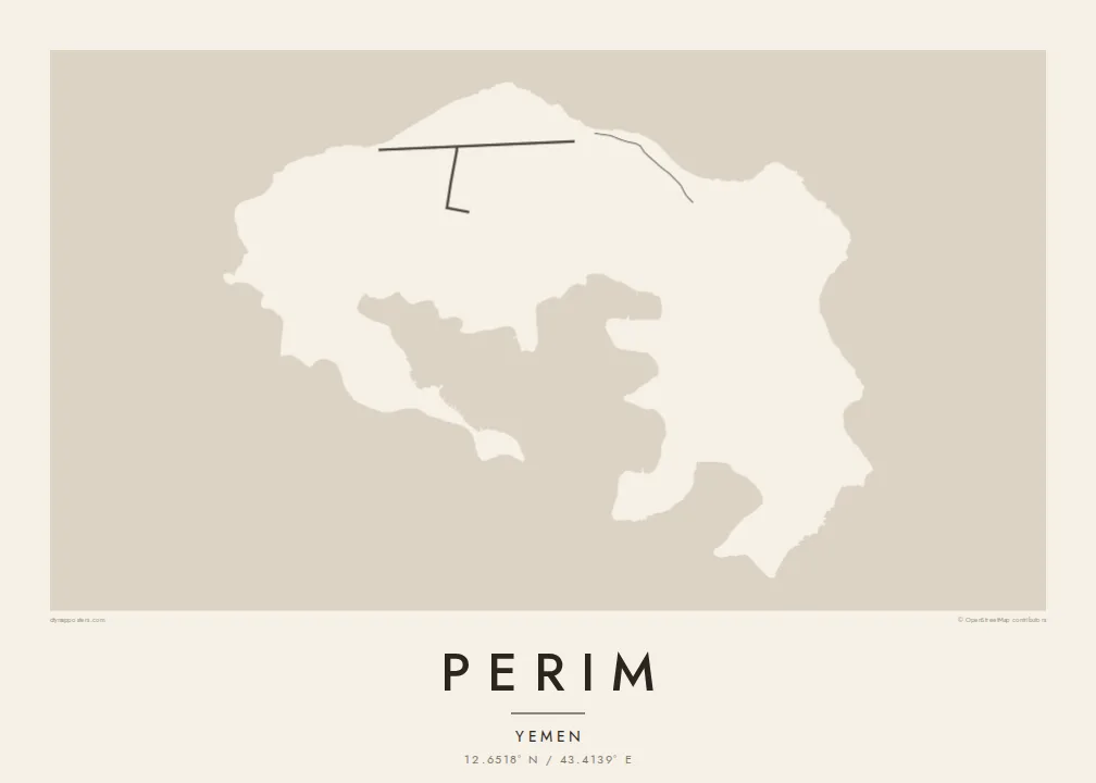
The island's core is a sheltered bay enclosed by curving arms of land, the flooded heart of an old volcano. It gives Perim its unmistakable horseshoe outline on the map.
سادہ نقشہ پوسٹر · یمن
12.6518° N / 43.4139° E
A small volcanic horseshoe in the Bab-el-Mandeb strait, curled around a sheltered natural harbour.




ایک شہر، پانچ انداز
کوئی بھی اسٹائل منتخب کریں اور دیکھیں دیوار پر کیسا لگتا ہے۔ ہر اسٹائل کی قیمت ایک جیسی ہے — پرنٹ، فریم یا HD فائلز کے طور پر۔
 اصل پکسلز · 24 × 36″ پرنٹ فائل
پرنٹ جیسی واضح
یہ اصل پرنٹ فائل کا 100% کراپ ہے۔ ہر پوسٹر — چاہے پرنٹ ہو، فریم شدہ ہو یا ڈاؤن لوڈ کیا گیا ہو — ہمارے سرورز پر 300 DPI اور 7,200 × 10,800 پکسلز تک رینڈر کیا جاتا ہے، تاکہ 24 × 36″ پرنٹ پر بھی سب سے باریک گلیاں تک صاف نظر آئیں۔
دیوار پر


نقشہ
Perim is a small island in the Bab-el-Mandeb, the strait that joins the Red Sea to the Gulf of Aden. It lies close to the Yemeni coast, in the narrow channel between Arabia and Africa. Its shape is the first thing you notice. The island is the remains of a volcanic crater, curled into a rough horseshoe around a deep, enclosed bay.
That natural harbour and the island's position on one of the world's busiest sea lanes gave Perim an outsized role in the past. In the late nineteenth and early twentieth centuries, the British used it as a coaling station for ships travelling between the Suez Canal and the Indian Ocean. Today it is sparsely inhabited, and it is known in Arabic as Mayun.
A Perim map poster is almost entirely about the coastline. The curved arms of the island wrap around the inner bay, and there is only a light scatter of lines on the land itself. Open water frames the island on all sides. The result is a spare, graphic shape that is easy to recognise at any size.
The island's core is a sheltered bay enclosed by curving arms of land, the flooded heart of an old volcano. It gives Perim its unmistakable horseshoe outline on the map.
Perim sits in the Bab-el-Mandeb, between the Arabian Peninsula and the Horn of Africa. At a wider framing, the poster shows the island guarding the narrow passage.
There are very few roads or buildings on the island. That leaves the land mostly blank, so the outline and inner harbour carry the entire composition.
اسے اپنا بنائیں
کوئی تاریخ، نام یا اپنی کوئی سطر شامل کریں، انداز، سائز یا رخ بدلیں۔
مفت پیش منظر کم ریزولیوشن اور واٹر مارک کے ساتھ ہوتا ہے۔ پرنٹس اور HD فائلز 300 DPI اور 7,200 × 10,800 px تک بغیر واٹر مارک کے رینڈر کی جاتی ہیں۔
Perim ہی کیوں
Perim appeals to people drawn to maritime history, shipping routes and unusual geography. Its horseshoe shape is striking on its own, even for those who have never been there. It suits a study or office wall as a clean, almost abstract form with a real story behind it.
Add a title of your choosing, a subtitle and your own coordinates line, then pick from Classic black & white, Noir, Paper, Blueprint or Sand. The $9 digital download includes six sizes at 300 DPI with no watermark. Printed posters ship from partners in more than 30 countries.
Perim پوسٹر آرڈر کریں| پرنٹ سائز | ریزولوشن | فائلیں |
|---|---|---|
| 30 × 40 cm (11.8 × 15.7″) | 3,543 × 4,724 px | PNG · PDF |
| 29.7 × 42 cm (A3, 11.7 × 16.5″) | 3,508 × 4,961 px | PNG · PDF |
| 42 × 59.4 cm (A2, 16.5 × 23.4″) | 4,961 × 7,016 px | PNG · PDF |
| 45.7 × 61 cm (18 × 24″) | 5,400 × 7,200 px | PNG · PDF |
| 50 × 70 cm (19.7 × 27.6″) | 5,906 × 8,268 px | PNG · PDF |
| 61 × 91.4 cm (24 × 36″) | 7,200 × 10,800 px | PNG · PDF |
موازنے کے لیے، مفت پیش نظارہ 900 px چوڑا ہے، واٹر مارک کے ساتھ اور اسکرین کے لیے ہے۔ HD فائلوں کی ریزولوشن ہر سمت میں 8 گنا تک زیادہ ہے اور پورے پوسٹر سائز پر صاف پرنٹ ہوتی ہیں۔
صفحے کے اوپر ایک اسٹائل منتخب کریں، پھر پرنٹڈ پوسٹر چنیں — سائز اور چاہیں تو فریم بھی — یا ڈیجیٹل HD فائلز۔ چیک آؤٹ صرف ایک مرحلے میں مکمل ہوتا ہے، اور ادائیگی مکمل ہوتے ہی آپ کا آرڈر پیج اپڈیٹ ہو جاتا ہے۔
یہ پریمیم 200 gsm میٹ پیپر پر چھ سائزز میں سے کسی ایک میں پرنٹ ہوتا ہے، 30 × 40 cm سے لے کر 24 × 36″ تک۔ پرنٹڈ پوسٹرز کی قیمت {printFrom} سے شروع ہوتی ہے، شپنگ شامل ہے۔
جی ہاں۔ سیاہ، سفید، قدرتی اوک یا گہری لکڑی میں سولڈ ووڈ فریم منتخب کریں۔ اس کے ساتھ ٹوٹ پھوٹ سے محفوظ شیشہ لگا ہوتا ہے اور یہ لٹکانے کے لیے تیار ہوتا ہے۔ فریم شدہ پوسٹرز کی قیمت {framedFrom} سے شروع ہوتی ہے، شپنگ شامل ہے۔
دنیا بھر میں شپنگ مفت ہے۔ ہر پوسٹر 30 سے زائد ممالک میں ہمارے قریب ترین پرنٹ پارٹنر کے ہاں چھپتا ہے اور عموماً 3–7 کاروباری دنوں میں پہنچ جاتا ہے۔ آرڈر کی صورتحال اور ٹریکنگ آپ میرے آرڈرز میں دیکھ سکتے ہیں۔ چند ممالک میں 2–5 ہفتے لگتے ہیں، اور جہاں ہم ابھی شپنگ نہیں کرتے وہاں ادائیگی سے پہلے سائٹ خود آپ کو بتا دیتی ہے۔
ڈیلیوری کے 14 دنوں کے اندر ہمیں تصویر بھیجیں اور ہم اسے مفت دوبارہ پرنٹ کر دیں گے یا آپ کی رقم واپس کر دیں گے۔
جی ہاں۔ اس صفحے کے ایڈیٹر میں عنوان، ذیلی عنوان اور کوآرڈینیٹس کی لائن کو اپنی مرضی کے مطابق تبدیل کریں، اور اسٹائل و سائز منتخب کریں۔ پرنٹڈ، فریم شدہ اور ڈیجیٹل — سب آرڈرز میں عین آپ کا ڈیزائن استعمال ہوتا ہے۔
$9 میں آپ کو 300 DPI PNG اور پرنٹ کے لیے تیار PDF فائلز چھ سائزز میں ملتی ہیں، بغیر واٹر مارک کے، جنہیں کہیں بھی پرنٹ کیا جا سکتا ہے۔ ابھی یقین نہیں؟ پہلے مفت واٹر مارک والا پیش منظر ڈاؤن لوڈ کریں۔
