Hilly terrain
Much of the district is upland, so roads curve and branch to follow the valleys. This gives the map a looser, more organic look than most cities on the Shandong plain.
سادہ نقشہ پوسٹر · چین
35.0753° N / 117.4578° E
A hilly district of Zaozhuang in southern Shandong, where valley towns and winding roads cross rugged, open country.




ایک شہر، پانچ انداز
کوئی بھی اسٹائل منتخب کریں اور دیکھیں دیوار پر کیسا لگتا ہے۔ ہر اسٹائل کی قیمت ایک جیسی ہے — پرنٹ، فریم یا HD فائلز کے طور پر۔
 اصل پکسلز · 24 × 36″ پرنٹ فائل
پرنٹ جیسی واضح
یہ اصل پرنٹ فائل کا 100% کراپ ہے۔ ہر پوسٹر — چاہے پرنٹ ہو، فریم شدہ ہو یا ڈاؤن لوڈ کیا گیا ہو — ہمارے سرورز پر 300 DPI اور 7,200 × 10,800 پکسلز تک رینڈر کیا جاتا ہے، تاکہ 24 × 36″ پرنٹ پر بھی سب سے باریک گلیاں تک صاف نظر آئیں۔
دیوار پر


نقشہ
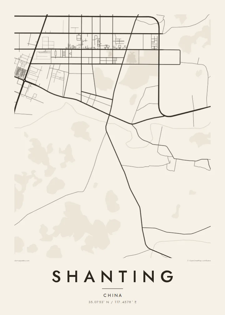
Shanting is a district of Zaozhuang in the south of Shandong province. Its name means roughly 'mountain pavilion', and the landscape fits it: much of the district is hilly, and settlements follow the valleys and lower ground. From above, the town centre forms a compact cluster of streets, while roads that bend with the terrain cross the surrounding country.
On a map this creates a strong contrast between the regular blocks of the built-up centre and the looser, contour-shaped roads and scattered villages beyond. Watercourses follow the valleys, and the open ground on the hills gives the composition room around the denser areas.
A Shanting map poster suits a vertical frame that centres the town and lets the surrounding hills fill the edges. The $9 digital download includes six sizes, from 30×40 cm to 24×36″, each as a 300 DPI PNG and a print-ready PDF without a watermark. A free 900 px preview lets you judge the balance.
Much of the district is upland, so roads curve and branch to follow the valleys. This gives the map a looser, more organic look than most cities on the Shandong plain.
The main town forms a concentrated cluster of blocks and streets. It is the densest part of the composition and a natural focal point.
Smaller settlements line the valleys and roads. They appear as small clusters that punctuate the open hill country around the centre.
اسے اپنا بنائیں
کوئی تاریخ، نام یا اپنی کوئی سطر شامل کریں، انداز، سائز یا رخ بدلیں۔
مفت پیش منظر کم ریزولیوشن اور واٹر مارک کے ساتھ ہوتا ہے۔ پرنٹس اور HD فائلز 300 DPI اور 7,200 × 10,800 px تک بغیر واٹر مارک کے رینڈر کی جاتی ہیں۔
Shanting ہی کیوں
People from Shanting often move to larger cities for study or work. A map of the valleys and streets they grew up among is a precise, personal reminder of home, and it works as a strong graphic image even for those who have never been there.
Personalise the title, subtitle and coordinates line, and choose one of five styles: Classic black & white, Noir, Paper, Blueprint or Sand. Printed posters on matte paper ship from partners in 30+ countries, with an optional wooden frame.
Shanting پوسٹر آرڈر کریں| پرنٹ سائز | ریزولوشن | فائلیں |
|---|---|---|
| 30 × 40 cm (11.8 × 15.7″) | 3,543 × 4,724 px | PNG · PDF |
| 29.7 × 42 cm (A3, 11.7 × 16.5″) | 3,508 × 4,961 px | PNG · PDF |
| 42 × 59.4 cm (A2, 16.5 × 23.4″) | 4,961 × 7,016 px | PNG · PDF |
| 45.7 × 61 cm (18 × 24″) | 5,400 × 7,200 px | PNG · PDF |
| 50 × 70 cm (19.7 × 27.6″) | 5,906 × 8,268 px | PNG · PDF |
| 61 × 91.4 cm (24 × 36″) | 7,200 × 10,800 px | PNG · PDF |
موازنے کے لیے، مفت پیش نظارہ 900 px چوڑا ہے، واٹر مارک کے ساتھ اور اسکرین کے لیے ہے۔ HD فائلوں کی ریزولوشن ہر سمت میں 8 گنا تک زیادہ ہے اور پورے پوسٹر سائز پر صاف پرنٹ ہوتی ہیں۔
صفحے کے اوپر ایک اسٹائل منتخب کریں، پھر پرنٹڈ پوسٹر چنیں — سائز اور چاہیں تو فریم بھی — یا ڈیجیٹل HD فائلز۔ چیک آؤٹ صرف ایک مرحلے میں مکمل ہوتا ہے، اور ادائیگی مکمل ہوتے ہی آپ کا آرڈر پیج اپڈیٹ ہو جاتا ہے۔
یہ پریمیم 200 gsm میٹ پیپر پر چھ سائزز میں سے کسی ایک میں پرنٹ ہوتا ہے، 30 × 40 cm سے لے کر 24 × 36″ تک۔ پرنٹڈ پوسٹرز کی قیمت {printFrom} سے شروع ہوتی ہے، شپنگ شامل ہے۔
جی ہاں۔ سیاہ، سفید، قدرتی اوک یا گہری لکڑی میں سولڈ ووڈ فریم منتخب کریں۔ اس کے ساتھ ٹوٹ پھوٹ سے محفوظ شیشہ لگا ہوتا ہے اور یہ لٹکانے کے لیے تیار ہوتا ہے۔ فریم شدہ پوسٹرز کی قیمت {framedFrom} سے شروع ہوتی ہے، شپنگ شامل ہے۔
شپنگ پوری دنیا میں مفت ہے۔ ہر پوسٹر 30 سے زائد ممالک میں موجود ہمارے قریب ترین پرنٹ پارٹنر کے ذریعے پرنٹ ہوتا ہے اور عام طور پر 3 سے 7 کاروباری دنوں میں پہنچ جاتا ہے۔ آپ اسٹیٹس اور ٹریکنگ My Orders کے تحت دیکھ سکتے ہیں۔
ڈیلیوری کے 14 دنوں کے اندر ہمیں تصویر بھیجیں اور ہم اسے مفت دوبارہ پرنٹ کر دیں گے یا آپ کی رقم واپس کر دیں گے۔
جی ہاں۔ اس صفحے کے ایڈیٹر میں عنوان، ذیلی عنوان اور کوآرڈینیٹس کی لائن کو اپنی مرضی کے مطابق تبدیل کریں، اور اسٹائل و سائز منتخب کریں۔ پرنٹڈ، فریم شدہ اور ڈیجیٹل — سب آرڈرز میں عین آپ کا ڈیزائن استعمال ہوتا ہے۔
$9 میں آپ کو 300 DPI PNG اور پرنٹ کے لیے تیار PDF فائلز چھ سائزز میں ملتی ہیں، بغیر واٹر مارک کے، جنہیں کہیں بھی پرنٹ کیا جا سکتا ہے۔ ابھی یقین نہیں؟ پہلے مفت واٹر مارک والا پیش منظر ڈاؤن لوڈ کریں۔
