Colonial grid
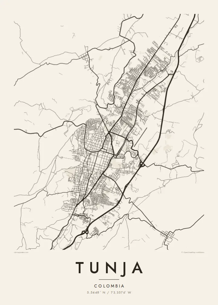
The historic centre keeps its original checkerboard around the Plaza de Bolívar, a square of regular blocks that stands out clearly at the middle of the map.
سادہ نقشہ پوسٹر · کولمبیا
5.5448° N / 73.3576° W
A high Andean capital laid out in a colonial grid, stretched north to south along a narrow valley between green ridges.




ایک شہر، پانچ انداز
کوئی بھی اسٹائل منتخب کریں اور دیکھیں دیوار پر کیسا لگتا ہے۔ ہر اسٹائل کی قیمت ایک جیسی ہے — پرنٹ، فریم یا HD فائلز کے طور پر۔
 اصل پکسلز · 24 × 36″ پرنٹ فائل
پرنٹ جیسی واضح
یہ اصل پرنٹ فائل کا 100% کراپ ہے۔ ہر پوسٹر — چاہے پرنٹ ہو، فریم شدہ ہو یا ڈاؤن لوڈ کیا گیا ہو — ہمارے سرورز پر 300 DPI اور 7,200 × 10,800 پکسلز تک رینڈر کیا جاتا ہے، تاکہ 24 × 36″ پرنٹ پر بھی سب سے باریک گلیاں تک صاف نظر آئیں۔
دیوار پر


نقشہ
Tunja, the capital of Boyacá, sits at around 2,800 metres, making it one of the highest departmental capitals in Colombia. It lies in a narrow valley running roughly north to south, and the city has grown along that axis rather than outward. On the map the result is an elongated shape, with the colonial centre near the middle and newer districts reaching up the slopes on either side.
Founded by the Spanish in 1539 on the site of a Muisca settlement, Tunja kept its checkerboard plan around the Plaza de Bolívar, one of the largest main squares in the country. Churches and colonial houses line the surrounding blocks. About fifteen kilometres to the south lies the Puente de Boyacá, where the decisive battle for independence was fought in 1819.
A Tunja map poster shows a city defined by both history and terrain. The regular grid of the old centre sits at the heart of the frame, main avenues run along the valley, and the streets bend and thin out where they meet the hills. It is a meaningful map for boyacenses at home or abroad, and for students of the city's universities.
The historic centre keeps its original checkerboard around the Plaza de Bolívar, a square of regular blocks that stands out clearly at the middle of the map.
The city stretches north to south along its valley, with main avenues following the same line and giving the poster a strong vertical composition.
On the edges, newer neighbourhoods climb the slopes, where streets curve with the contours and the tidy grid gives way to a looser, more organic pattern.
اسے اپنا بنائیں
کوئی تاریخ، نام یا اپنی کوئی سطر شامل کریں، انداز، سائز یا رخ بدلیں۔
مفت پیش منظر کم ریزولیوشن اور واٹر مارک کے ساتھ ہوتا ہے۔ پرنٹس اور HD فائلز 300 DPI اور 7,200 × 10,800 px تک بغیر واٹر مارک کے رینڈر کی جاتی ہیں۔
Tunja ہی کیوں
Tunja is a city of students and of families with deep Boyacá roots. A map of its grid and valley is a thoughtful way to remember university years, a hometown or the place near which Colombian independence was won.
The title, subtitle and coordinates line can be personalised with a name, graduation year or date, and five styles are available: Classic black & white, Noir, Paper, Blueprint and Sand. Paper suits the colonial centre especially well.
Tunja پوسٹر آرڈر کریں| پرنٹ سائز | ریزولوشن | فائلیں |
|---|---|---|
| 30 × 40 cm (11.8 × 15.7″) | 3,543 × 4,724 px | PNG · PDF |
| 29.7 × 42 cm (A3, 11.7 × 16.5″) | 3,508 × 4,961 px | PNG · PDF |
| 42 × 59.4 cm (A2, 16.5 × 23.4″) | 4,961 × 7,016 px | PNG · PDF |
| 45.7 × 61 cm (18 × 24″) | 5,400 × 7,200 px | PNG · PDF |
| 50 × 70 cm (19.7 × 27.6″) | 5,906 × 8,268 px | PNG · PDF |
| 61 × 91.4 cm (24 × 36″) | 7,200 × 10,800 px | PNG · PDF |
موازنے کے لیے، مفت پیش نظارہ 900 px چوڑا ہے، واٹر مارک کے ساتھ اور اسکرین کے لیے ہے۔ HD فائلوں کی ریزولوشن ہر سمت میں 8 گنا تک زیادہ ہے اور پورے پوسٹر سائز پر صاف پرنٹ ہوتی ہیں۔
صفحے کے اوپر ایک اسٹائل منتخب کریں، پھر پرنٹڈ پوسٹر چنیں — سائز اور چاہیں تو فریم بھی — یا ڈیجیٹل HD فائلز۔ چیک آؤٹ صرف ایک مرحلے میں مکمل ہوتا ہے، اور ادائیگی مکمل ہوتے ہی آپ کا آرڈر پیج اپڈیٹ ہو جاتا ہے۔
یہ پریمیم 200 gsm میٹ پیپر پر چھ سائزز میں سے کسی ایک میں پرنٹ ہوتا ہے، 30 × 40 cm سے لے کر 24 × 36″ تک۔ پرنٹڈ پوسٹرز کی قیمت $39 سے شروع ہوتی ہے، شپنگ شامل ہے۔
جی ہاں۔ سیاہ، سفید، قدرتی اوک یا گہری لکڑی میں سولڈ ووڈ فریم منتخب کریں۔ اس کے ساتھ ٹوٹ پھوٹ سے محفوظ شیشہ لگا ہوتا ہے اور یہ لٹکانے کے لیے تیار ہوتا ہے۔ فریم شدہ پوسٹرز کی قیمت $99 سے شروع ہوتی ہے، شپنگ شامل ہے۔
دنیا بھر میں شپنگ مفت ہے۔ ہر پوسٹر 30 سے زائد ممالک میں ہمارے قریب ترین پرنٹ پارٹنر کے ہاں چھپتا ہے اور عموماً 3–7 کاروباری دنوں میں پہنچ جاتا ہے۔ آرڈر کی صورتحال اور ٹریکنگ آپ میرے آرڈرز میں دیکھ سکتے ہیں۔ چند ممالک میں 2–5 ہفتے لگتے ہیں، اور جہاں ہم ابھی شپنگ نہیں کرتے وہاں ادائیگی سے پہلے سائٹ خود آپ کو بتا دیتی ہے۔
ڈیلیوری کے 14 دنوں کے اندر ہمیں تصویر بھیجیں اور ہم اسے مفت دوبارہ پرنٹ کر دیں گے یا آپ کی رقم واپس کر دیں گے۔
جی ہاں۔ اس صفحے کے ایڈیٹر میں عنوان، ذیلی عنوان اور کوآرڈینیٹس کی لائن کو اپنی مرضی کے مطابق تبدیل کریں، اور اسٹائل و سائز منتخب کریں۔ پرنٹڈ، فریم شدہ اور ڈیجیٹل — سب آرڈرز میں عین آپ کا ڈیزائن استعمال ہوتا ہے۔
$9 میں آپ کو 300 DPI PNG اور پرنٹ کے لیے تیار PDF فائلز چھ سائزز میں ملتی ہیں، بغیر واٹر مارک کے، جنہیں کہیں بھی پرنٹ کیا جا سکتا ہے۔ ابھی یقین نہیں؟ پہلے مفت واٹر مارک والا پیش منظر ڈاؤن لوڈ کریں۔
