Town centre
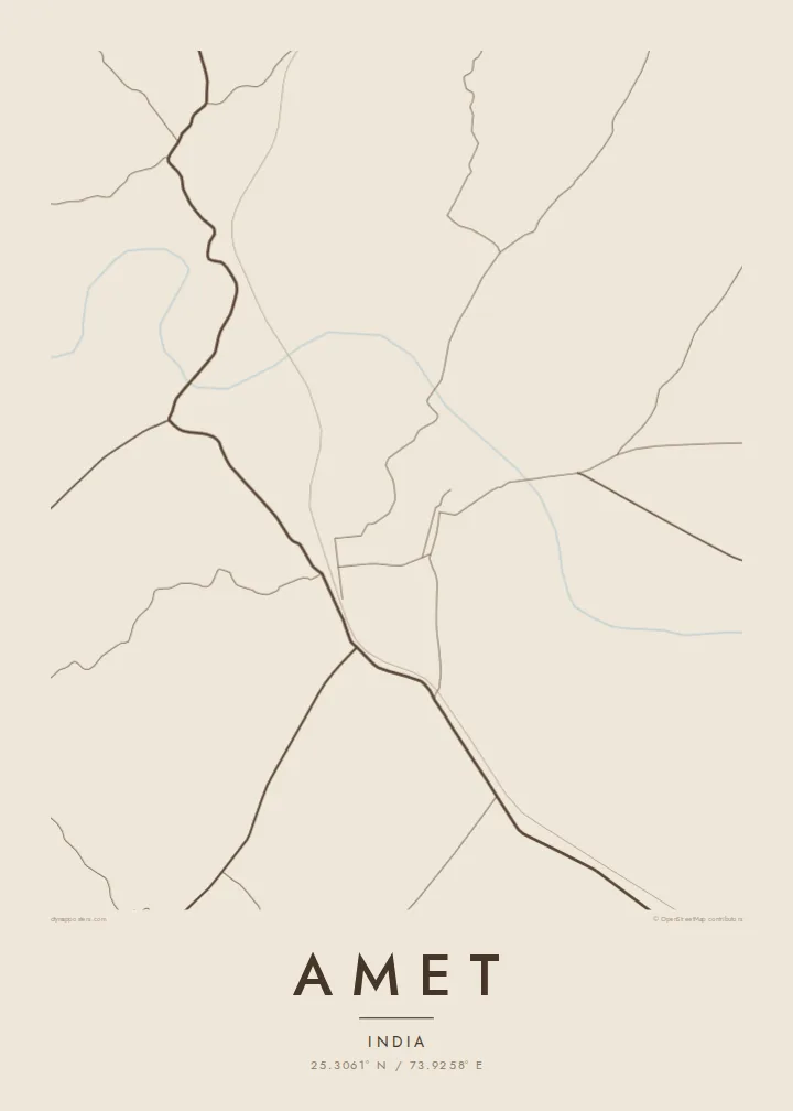
Narrow lanes and closely packed buildings form a compact core. On the poster this concentrated area contrasts sharply with the open hills around it.
Qeeqabak kaartah poster · India
25.3061° N / 73.9258° E
A small town in Rajasthan's Rajsamand district, set among rocky Aravalli ridges, with roads threading between dry hills.


Inki magaala, konoy gaba
Qande inkih tibbixeeh derre baguley table. Kulli qande missoowa caagid—daabbisimta, dirbaabu-le kaadu HD fayla akah.
 Cagalah pixels · 24 × 36″ daabbi fayla
Maxxaacah qeeqa
Tama usuk cagalah daabbi faylak 100% qambaala. Kulli poster — daabbisimta, dirbaabu-le kaadu download geytimta — ni-server-ittal 300 DPI-l ederimta, 7,200 × 10,800 pixels fanah, tokkel iyyi ellee catoy 24 × 36″ daabbi baxsi bahisak raaqu.
Gidarih


Kaarta
Amet lies in Rajsamand district in southern Rajasthan, in broken country where the Aravalli range spreads into low, rocky hills. The map shows a compact centre of narrow lanes, with roads leaving in several directions and finding their way between ridges. Seasonal streams and small bodies of water mark the lower ground, and fields fill whatever flat land the hills leave.
The town belongs to the historic region of Mewar, and for centuries it was the seat of one of the noble estates owing allegiance to the rulers of Udaipur. Today it is a tehsil headquarters and a local town for the surrounding villages, with markets serving the farming communities of the area.
An Amet map poster shows a town closely tied to its terrain. The dense core, the roads bending around the hills and the pale, open ground of the ridges give the print an unusual, irregular rhythm, far from the ordered grids of planned towns.
Narrow lanes and closely packed buildings form a compact core. On the poster this concentrated area contrasts sharply with the open hills around it.
Rocky hills rise around the town and push the roads into curves and detours. They leave broad empty shapes that frame the built-up area.
Seasonal streams and small water bodies sit in the dips between hills. They add soft, irregular marks to the lower parts of the map.
Kok tanim ab
Ayro, migaq hinnay kok tan xagar osis; gaba, ballaqa hinnay xiqa soorris.
Free preview qansarissi kee watermark-le. Daabbisimtaan kee HD fayla 300 DPI-l, 7,200 × 10,800 px fanah, watermark maleh ederimta.
Macah Amet
For families with roots in Mewar, Amet is more than a name on the road from Rajsamand. A map of the town keeps its lanes and hills on the wall, and makes a meaningful gift for elders or for relatives settled in other cities.
The poster can be personalised with a title, a subtitle such as a family name or a date, and a coordinates line. Sand and Paper suit the dry hills, while Noir is bolder. HD files are $9, and printed matte posters can be ordered with an optional wooden frame.
Amet poster orme| Maxxaacah ballaqa | Qeeqa | Faylal |
|---|---|---|
| 30 × 40 cm (11.8 × 15.7″) | 3,543 × 4,724 px | PNG · PDF |
| 29.7 × 42 cm (A3, 11.7 × 16.5″) | 3,508 × 4,961 px | PNG · PDF |
| 42 × 59.4 cm (A2, 16.5 × 23.4″) | 4,961 × 7,016 px | PNG · PDF |
| 45.7 × 61 cm (18 × 24″) | 5,400 × 7,200 px | PNG · PDF |
| 50 × 70 cm (19.7 × 27.6″) | 5,906 × 8,268 px | PNG · PDF |
| 61 × 91.4 cm (24 × 36″) | 7,200 × 10,800 px | PNG · PDF |
Tabbaltah, limo-wayta xaqqa-le ablo 900 px ballaqa le, asta le, iskiriinih keh tan. HD faylal gexsoh inkih addal 8× fanah qeeqa le, poster ballaqa inkih addal meqeh maxxaacimta.
Baxxaqqa qari le qandiy dooriy, tohuk lakal Daabbisimtah Poster — kutuk kee, faxximek, dirbaabu — hinnay HD Digital Fayla dooru. Checkout inki wagitti geytima, kaadu ku-orme page keenih adissa akke waqdi caagoy kummite.
Usuk 200 gsm-le catam kutuk warqatal, lica katiy caagitte {printFrom}-ik hane ayta 30 × 40 cm-ik 24 × 36″ fanah, xaagu keenil warreeh.
Ee. Sarrah-le dirbaabu doori — bad, gudduc, oak-le hinnay bad-madabuy. Usuk finqisiimam ellee sange qarab-le kaadu qari umukku iyya keenih taagu. Dirbaabu-le poster {framedFrom}-ik hane, xaagu keenil warreeh.
Shipping is free worldwide. Each poster is printed by the nearest of our print partners in 30+ countries and usually arrives in 3–7 business days. You can follow the status and tracking under My Orders. A few countries take 2–5 weeks, and where we don't ship yet, the site tells you before you pay.
Geytimeek 14 ayróy addal foto naah rubbaay, cisab-le daabbisiynah hinnay ku-lacay gacisnaah.
Ee. Tama page-l edito addal, migaaq, subtitle kee coordinates sarrah faxxem fanah badal, kaadu qande kee katiy doori. Daabbisimtah, dirbaabu-le kaadu digital orme inkih ku-design cagalah yekkelen.
$9 bacisak 300 DPI PNG kee daabbisimtah adissime PDF fayla lica katiy inkih, watermark maleh, ayyi meki daabbisimtah geeytitta. Cisab makkoysemty ana? Awqak, watermark-le free preview download-eh.
Xayyo
