Thames meanders
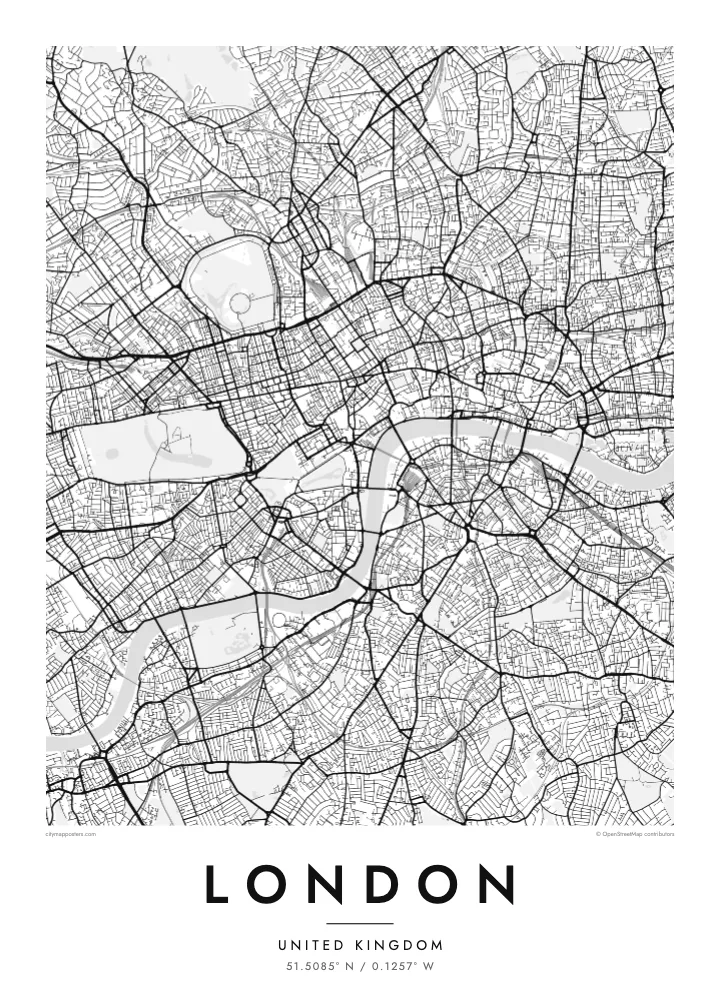
Between Westminster and Greenwich the river swings through a run of sharp bends, including the horseshoe loop around the Isle of Dogs, one of the most recognisable shapes on any city map.
Qeeqabak kaartah poster · United Kingdom
51.5085° N / 0.1257° W
No grid and no plan, just a winding river and centuries of villages that grew together into one enormous city.


Inki magaala, konoy gaba
Qande inkih tibbixeeh derre baguley table. Kulli qande missoowa caagid—daabbisimta, dirbaabu-le kaadu HD fayla akah.
 Cagalah pixels · 24 × 36″ daabbi fayla
Maxxaacah qeeqa
Tama usuk cagalah daabbi faylak 100% qambaala. Kulli poster — daabbisimta, dirbaabu-le kaadu download geytimta — ni-server-ittal 300 DPI-l ederimta, 7,200 × 10,800 pixels fanah, tokkel iyyi ellee catoy 24 × 36″ daabbi baxsi bahisak raaqu.
Gidarih


Kaarta
London has never had a master plan, and its street map shows it. There is no grid and no dominant axis, only a web of roads that once linked separate villages such as Hampstead, Chelsea and Islington before the city absorbed them. Street names still hint at those origins, and the map reads less like a design than a record of slow accumulation.
The Thames gives it shape. The river snakes from west to east in a series of tight loops, the deepest wrapping around the Isle of Dogs, where Canary Wharf now stands. Upstream sits the City of London, the Square Mile where the Romans founded Londinium, still a separate jurisdiction with its own dense knot of lanes around St Paul's.
Green space breaks up the pattern more than in most capitals. Hyde Park and Kensington Gardens form one broad block in the west, Regent's Park adds its neat Inner Circle to the north, and Hampstead Heath spreads wild and irregular beyond. On a London map poster these parks read as open pauses in an otherwise restless texture of streets.
Between Westminster and Greenwich the river swings through a run of sharp bends, including the horseshoe loop around the Isle of Dogs, one of the most recognisable shapes on any city map.
The City of London, where the Roman settlement began, still follows much of its medieval street pattern of narrow lanes and courts, rebuilt on the old lines after the Great Fire of 1666.
Opened in the early nineteenth century, the canal curves across north London from Little Venice to Limehouse, passing Camden and the edge of Regent's Park as a thin, continuous line of water.
Kok tanim ab
Ayro, migaq hinnay kok tan xagar osis; gaba, ballaqa hinnay xiqa soorris.
Free preview qansarissi kee watermark-le. Daabbisimtaan kee HD fayla 300 DPI-l, 7,200 × 10,800 px fanah, watermark maleh ederimta.
Macah London
London is a city people pass through as often as they settle in, which makes its map a natural keepsake. It can mark a first job, a flatshare in Hackney, years of commuting on the Underground, or a single trip that stayed with you long after the flight home.
Personalise the poster with a title and a date of your choosing, then settle on one of five styles: Classic black & white, Noir, Paper, Blueprint or Sand. Blueprint suits the engineering of the bridges, while Paper and Sand soften the maze of streets for a quieter room.
London poster orme| Maxxaacah ballaqa | Qeeqa | Faylal |
|---|---|---|
| 30 × 40 cm11.8 × 15.7″ | 3,543 × 4,724 px | PNG · PDF |
| 29.7 × 42 cm (A3)11.7 × 16.5″ | 3,508 × 4,961 px | PNG · PDF |
| 42 × 59.4 cm (A2)16.5 × 23.4″ | 4,961 × 7,016 px | PNG · PDF |
| 45.7 × 61 cm18 × 24″ | 5,400 × 7,200 px | PNG · PDF |
| 50 × 70 cm19.7 × 27.6″ | 5,906 × 8,268 px | PNG · PDF |
| 61 × 91.4 cm24 × 36″ | 7,200 × 10,800 px | PNG · PDF |
Tabbaltah, limo-wayta xaqqa-le ablo 900 px ballaqa le, asta le, iskiriinih keh tan. HD faylal gexsoh inkih addal 8× fanah qeeqa le, poster ballaqa inkih addal meqeh maxxaacimta.
Baxxaqqa qari le qandiy dooriy, tohuk lakal Daabbisimtah Poster — kutuk kee, faxximek, dirbaabu — hinnay HD Digital Fayla dooru. Checkout inki wagitti geytima, kaadu ku-orme page keenih adissa akke waqdi caagoy kummite.
Usuk 200 gsm-le catam kutuk warqatal, lica katiy caagitte $39-ik hane ayta 30 × 40 cm-ik 24 × 36″ fanah, xaagu keenil warreeh.
Ee. Sarrah-le dirbaabu doori — bad, gudduc, oak-le hinnay bad-madabuy. Usuk finqisiimam ellee sange qarab-le kaadu qari umukku iyya keenih taagu. Dirbaabu-le poster $99-ik hane, xaagu keenil warreeh.
Dirsa 60+ baaxoh bilsa. Poster kasa 30+ baaxoh nel print kaadu yan kee dirgeh kaxxa kee tanah printa, kee 3–7 xaqu ayyaamah yaaxigeeh. Xaaloo kee tracking "Ac Order" gexsitam. Kaadu baaxo 2–5 isbuuc yaaxigeeh, nanu dirsi yanin baaxoh sajiitah site ku kalah tekkeh.
Geytimeek 14 ayróy addal foto naah rubbaay, cisab-le daabbisiynah hinnay ku-lacay gacisnaah.
Ee. Tama page-l edito addal, migaaq, subtitle kee coordinates sarrah faxxem fanah badal, kaadu qande kee katiy doori. Daabbisimtah, dirbaabu-le kaadu digital orme inkih ku-design cagalah yekkelen.
$9 bacisak 300 DPI PNG kee daabbisimtah adissime PDF fayla lica katiy inkih, watermark maleh, ayyi meki daabbisimtah geeytitta. Cisab makkoysemty ana? Awqak, watermark-le free preview download-eh.
