Colonial-era grid
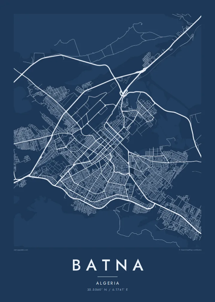
The historic core is laid out in straight streets meeting at right angles, a regular pattern that stands out sharply at the centre of the map.
Qeeqabak kaartah poster · Algeria
35.5560° N / 6.1741° E
A high plateau city in the Aurès, laid out on a colonial grid, with Roman Timgad and Lambaesis close by



Inki magaala, konoy gaba
Qande inkih tibbixeeh derre baguley table. Kulli qande missoowa caagid—daabbisimta, dirbaabu-le kaadu HD fayla akah.
 Cagalah pixels · 24 × 36″ daabbi fayla
Maxxaacah qeeqa
Tama usuk cagalah daabbi faylak 100% qambaala. Kulli poster — daabbisimta, dirbaabu-le kaadu download geytimta — ni-server-ittal 300 DPI-l ederimta, 7,200 × 10,800 pixels fanah, tokkel iyyi ellee catoy 24 × 36″ daabbi baxsi bahisak raaqu.
Gidarih


Kaarta
Batna stands on a high plateau in northeastern Algeria, around 1,000 metres above sea level, in a basin enclosed by the Aurès mountains. It began in 1844 as a French military camp, and the older centre still keeps the straight, regular streets of that period. Since then the city has spread widely in every direction across the valley floor.
The region around Batna is one of the richest in Roman remains in North Africa. Timgad, a colony founded under Trajan with an almost perfect grid plan, lies to the east. Lambaesis, headquarters of the Third Augustan Legion, is even closer. Batna is also regarded as a cradle of the Algerian War of Independence, which began in the Aurès in 1954.
A Batna map poster draws on that long tradition of planned cities. The regular blocks of the centre, the wide avenues added during the twentieth century and the mountains closing in on the basin make a clear, confident image, with the bare slopes of the Aurès as a quiet frame.
The historic core is laid out in straight streets meeting at right angles, a regular pattern that stands out sharply at the centre of the map.
Ridges and slopes of the Aurès surround the basin. They hold the city within the shape of its valley and leave the edges of the poster open and calm.
Main roads lead east and southeast out of the city toward the Roman sites of Lambaesis and Timgad, whose own grids echo Batna's plan.
Kok tanim ab
Ayro, migaq hinnay kok tan xagar osis; gaba, ballaqa hinnay xiqa soorris.
Free preview qansarissi kee watermark-le. Daabbisimtaan kee HD fayla 300 DPI-l, 7,200 × 10,800 px fanah, watermark maleh ederimta.
Macah Batna
For Chaoui families and anyone who grew up in Batna, the city's plan holds memories of school, market and family streets. For others, Batna is the gateway to the Aurès and to some of the finest Roman ruins in North Africa.
Choose a title and subtitle, perhaps with a family name or a date, adjust the coordinates, and select one of five styles, from Paper to Sand. Download the six-size HD package for $9 or have a matte print shipped from partners in 30+ countries.
Batna poster orme| Maxxaacah ballaqa | Qeeqa | Faylal |
|---|---|---|
| 30 × 40 cm (11.8 × 15.7″) | 3,543 × 4,724 px | PNG · PDF |
| 29.7 × 42 cm (A3, 11.7 × 16.5″) | 3,508 × 4,961 px | PNG · PDF |
| 42 × 59.4 cm (A2, 16.5 × 23.4″) | 4,961 × 7,016 px | PNG · PDF |
| 45.7 × 61 cm (18 × 24″) | 5,400 × 7,200 px | PNG · PDF |
| 50 × 70 cm (19.7 × 27.6″) | 5,906 × 8,268 px | PNG · PDF |
| 61 × 91.4 cm (24 × 36″) | 7,200 × 10,800 px | PNG · PDF |
Tabbaltah, limo-wayta xaqqa-le ablo 900 px ballaqa le, asta le, iskiriinih keh tan. HD faylal gexsoh inkih addal 8× fanah qeeqa le, poster ballaqa inkih addal meqeh maxxaacimta.
Baxxaqqa qari le qandiy dooriy, tohuk lakal Daabbisimtah Poster — kutuk kee, faxximek, dirbaabu — hinnay HD Digital Fayla dooru. Checkout inki wagitti geytima, kaadu ku-orme page keenih adissa akke waqdi caagoy kummite.
Usuk 200 gsm-le catam kutuk warqatal, lica katiy caagitte {printFrom}-ik hane ayta 30 × 40 cm-ik 24 × 36″ fanah, xaagu keenil warreeh.
Ee. Sarrah-le dirbaabu doori — bad, gudduc, oak-le hinnay bad-madabuy. Usuk finqisiimam ellee sange qarab-le kaadu qari umukku iyya keenih taagu. Dirbaabu-le poster {framedFrom}-ik hane, xaagu keenil warreeh.
Xaagu addunyal inkih cisab-le. Kulli poster 30+ ummattak ni-daabbi-mara mananih xayyoysa kaadu 3–7 caagu-ayróh fanah geeytima. Ku-orme kee xaagu tarikiy My Orders addal ablitta.
Geytimeek 14 ayróy addal foto naah rubbaay, cisab-le daabbisiynah hinnay ku-lacay gacisnaah.
Ee. Tama page-l edito addal, migaaq, subtitle kee coordinates sarrah faxxem fanah badal, kaadu qande kee katiy doori. Daabbisimtah, dirbaabu-le kaadu digital orme inkih ku-design cagalah yekkelen.
$9 bacisak 300 DPI PNG kee daabbisimtah adissime PDF fayla lica katiy inkih, watermark maleh, ayyi meki daabbisimtah geeytitta. Cisab makkoysemty ana? Awqak, watermark-le free preview download-eh.
