Lac de Créteil
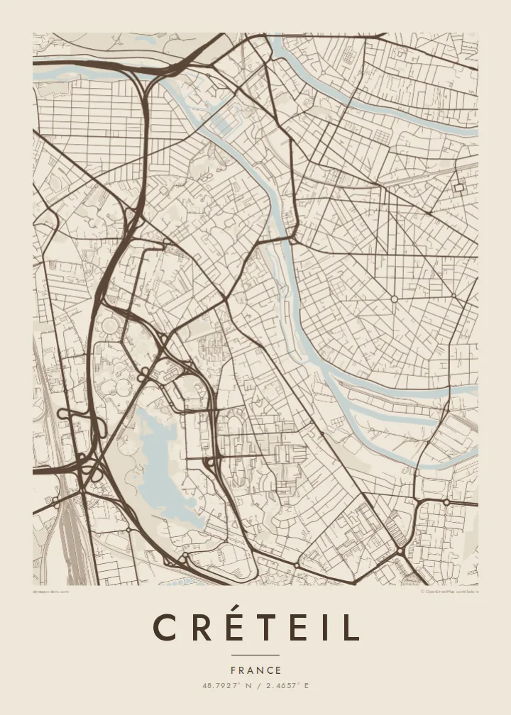
The large artificial lake near the centre of the city forms a smooth, open shape on the map, framed by parks, walkways and residential districts.
Qeeqabak kaartah poster · France
48.7927° N / 2.4657° E
A modern prefecture on a bend of the Marne, planned around a large artificial lake southeast of Paris.


Inki magaala, konoy gaba
Qande inkih tibbixeeh derre baguley table. Kulli qande missoowa caagid—daabbisimta, dirbaabu-le kaadu HD fayla akah.
 Cagalah pixels · 24 × 36″ daabbi fayla
Maxxaacah qeeqa
Tama usuk cagalah daabbi faylak 100% qambaala. Kulli poster — daabbisimta, dirbaabu-le kaadu download geytimta — ni-server-ittal 300 DPI-l ederimta, 7,200 × 10,800 pixels fanah, tokkel iyyi ellee catoy 24 × 36″ daabbi baxsi bahisak raaqu.
Gidarih


Kaarta
Créteil lies southeast of Paris and is the prefecture of the Val-de-Marne department. The Marne River curves along its northern edge, and the map combines an old village core with extensive modern development. The most striking feature is the large artificial lake in the southern part of the city, surrounded by parks, housing and civic buildings.
From the 1960s onward, Créteil was transformed into a new administrative centre, with a prefecture, a university and major housing projects. Among its best-known buildings are the Choux de Créteil, residential towers whose curved balconies resemble cabbage leaves. Line 8 of the Paris Métro ends in the city, linking it directly with the capital.
A Créteil map poster shows a city of contrasts: the curves of the Marne and the islands along its banks, the smooth outline of the lake, and the geometric forms of the planned districts laid out around it. It is an image of postwar ambition shaped by water, a place where modern planning met the landscape of the river valley.
The large artificial lake near the centre of the city forms a smooth, open shape on the map, framed by parks, walkways and residential districts.
The Marne bends around the city's northern edge. Wooded islands and riverside paths add soft curves and form a natural boundary.
Neighbourhoods built from the 1960s onward are laid out in distinctive geometric patterns, from curving slab blocks to clusters of towers around open spaces.
Kok tanim ab
Ayro, migaq hinnay kok tan xagar osis; gaba, ballaqa hinnay xiqa soorris.
Free preview qansarissi kee watermark-le. Daabbisimtaan kee HD fayla 300 DPI-l, 7,200 × 10,800 px fanah, watermark maleh ederimta.
Macah Créteil
Students of the university, residents of Val-de-Marne and anyone with ties to the eastern suburbs of Paris hang this map to remember the lake and the river. Its mix of water and modern forms makes an unusually graphic poster.
Personalise the title and subtitle with a neighbourhood, an address or a date, and edit the coordinates line. Choose from five styles, Classic black & white, Noir, Paper, Blueprint and Sand, as HD files or a printed poster shipped from a nearby print partner.
Créteil poster orme| Maxxaacah ballaqa | Qeeqa | Faylal |
|---|---|---|
| 30 × 40 cm (11.8 × 15.7″) | 3,543 × 4,724 px | PNG · PDF |
| 29.7 × 42 cm (A3, 11.7 × 16.5″) | 3,508 × 4,961 px | PNG · PDF |
| 42 × 59.4 cm (A2, 16.5 × 23.4″) | 4,961 × 7,016 px | PNG · PDF |
| 45.7 × 61 cm (18 × 24″) | 5,400 × 7,200 px | PNG · PDF |
| 50 × 70 cm (19.7 × 27.6″) | 5,906 × 8,268 px | PNG · PDF |
| 61 × 91.4 cm (24 × 36″) | 7,200 × 10,800 px | PNG · PDF |
Tabbaltah, limo-wayta xaqqa-le ablo 900 px ballaqa le, asta le, iskiriinih keh tan. HD faylal gexsoh inkih addal 8× fanah qeeqa le, poster ballaqa inkih addal meqeh maxxaacimta.
Baxxaqqa qari le qandiy dooriy, tohuk lakal Daabbisimtah Poster — kutuk kee, faxximek, dirbaabu — hinnay HD Digital Fayla dooru. Checkout inki wagitti geytima, kaadu ku-orme page keenih adissa akke waqdi caagoy kummite.
Usuk 200 gsm-le catam kutuk warqatal, lica katiy caagitte $39-ik hane ayta 30 × 40 cm-ik 24 × 36″ fanah, xaagu keenil warreeh.
Ee. Sarrah-le dirbaabu doori — bad, gudduc, oak-le hinnay bad-madabuy. Usuk finqisiimam ellee sange qarab-le kaadu qari umukku iyya keenih taagu. Dirbaabu-le poster $99-ik hane, xaagu keenil warreeh.
Shipping is free worldwide. Each poster is printed by the nearest of our print partners in 30+ countries and usually arrives in 3–7 business days. You can follow the status and tracking under My Orders. A few countries take 2–5 weeks, and where we don't ship yet, the site tells you before you pay.
Geytimeek 14 ayróy addal foto naah rubbaay, cisab-le daabbisiynah hinnay ku-lacay gacisnaah.
Ee. Tama page-l edito addal, migaaq, subtitle kee coordinates sarrah faxxem fanah badal, kaadu qande kee katiy doori. Daabbisimtah, dirbaabu-le kaadu digital orme inkih ku-design cagalah yekkelen.
$9 bacisak 300 DPI PNG kee daabbisimtah adissime PDF fayla lica katiy inkih, watermark maleh, ayyi meki daabbisimtah geeytitta. Cisab makkoysemty ana? Awqak, watermark-le free preview download-eh.
Xayyo
