Great Mosque
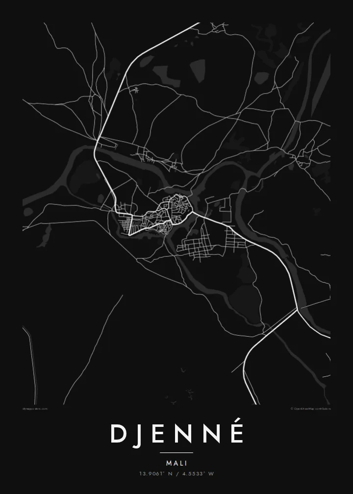
The mosque's broad rectangle and adjoining market square form the clearest landmark on the map, a calm geometric shape set within the dense fabric of the town.
Qeeqabak kaartah poster · Mali
13.9061° N / 4.5533° W
An ancient mud-brick town on a seasonal island in the Bani floodplain, its dense lanes gathered around the Great Mosque.



Inki magaala, konoy gaba
Qande inkih tibbixeeh derre baguley table. Kulli qande missoowa caagid—daabbisimta, dirbaabu-le kaadu HD fayla akah.
 Cagalah pixels · 24 × 36″ daabbi fayla
Maxxaacah qeeqa
Tama usuk cagalah daabbi faylak 100% qambaala. Kulli poster — daabbisimta, dirbaabu-le kaadu download geytimta — ni-server-ittal 300 DPI-l ederimta, 7,200 × 10,800 pixels fanah, tokkel iyyi ellee catoy 24 × 36″ daabbi baxsi bahisak raaqu.
Gidarih


Kaarta
Djenné stands in the inland delta of the Niger in central Mali, on land that becomes an island when the Bani river and its channels flood each year. The old town is a compact, rounded mass of houses and courtyards, built almost entirely of sun-dried mud brick. From above, it appears as a tightly packed maze of narrow lanes, with no clear grid and very little open space.
At its heart lies the Great Mosque, the largest mud-brick building in the world, rebuilt in its present form in 1907, and the square in front of it, where a weekly Monday market gathers traders from across the region. A Djenné map poster shows the mosque's large rectangular footprint as the one clear, regular form within the intricate web of lanes.
The old towns of Djenné, together with nearby archaeological sites such as Djenné-Djeno, are listed as a UNESCO World Heritage Site, and Djenné-Djeno is regarded as one of the oldest known urban sites in sub-Saharan Africa. Around the town, the floodplain spreads out in channels, marshes and fields that change with the seasons, giving the map an open, watery frame.
The mosque's broad rectangle and adjoining market square form the clearest landmark on the map, a calm geometric shape set within the dense fabric of the town.
Narrow lanes twist between courtyard houses, producing an intricate, irregular street pattern that fills the old town and reads as fine texture in black and white.
Channels of the Bani floodplain surround the town, isolating it during high water and giving the map its distinctive enclosed, island-like outline.
Kok tanim ab
Ayro, migaq hinnay kok tan xagar osis; gaba, ballaqa hinnay xiqa soorris.
Free preview qansarissi kee watermark-le. Daabbisimtaan kee HD fayla 300 DPI-l, 7,200 × 10,800 px fanah, watermark maleh ederimta.
Macah Djenné
Djenné is one of the most recognisable towns in West Africa, and its plan carries many centuries of continuous settlement. For those who have visited, studied its architecture, or have roots in the Mopti region, a map of its lanes and waters is a meaningful piece.
The title, subtitle and coordinates can be personalised, so the poster can mark a journey, a research trip or a family connection. Choose Classic black & white, Noir, Paper, Blueprint or Sand, and download it for $9 or order a matte print.
Djenné poster orme| Maxxaacah ballaqa | Qeeqa | Faylal |
|---|---|---|
| 30 × 40 cm (11.8 × 15.7″) | 3,543 × 4,724 px | PNG · PDF |
| 29.7 × 42 cm (A3, 11.7 × 16.5″) | 3,508 × 4,961 px | PNG · PDF |
| 42 × 59.4 cm (A2, 16.5 × 23.4″) | 4,961 × 7,016 px | PNG · PDF |
| 45.7 × 61 cm (18 × 24″) | 5,400 × 7,200 px | PNG · PDF |
| 50 × 70 cm (19.7 × 27.6″) | 5,906 × 8,268 px | PNG · PDF |
| 61 × 91.4 cm (24 × 36″) | 7,200 × 10,800 px | PNG · PDF |
Tabbaltah, limo-wayta xaqqa-le ablo 900 px ballaqa le, asta le, iskiriinih keh tan. HD faylal gexsoh inkih addal 8× fanah qeeqa le, poster ballaqa inkih addal meqeh maxxaacimta.
Baxxaqqa qari le qandiy dooriy, tohuk lakal Daabbisimtah Poster — kutuk kee, faxximek, dirbaabu — hinnay HD Digital Fayla dooru. Checkout inki wagitti geytima, kaadu ku-orme page keenih adissa akke waqdi caagoy kummite.
Usuk 200 gsm-le catam kutuk warqatal, lica katiy caagitte {printFrom}-ik hane ayta 30 × 40 cm-ik 24 × 36″ fanah, xaagu keenil warreeh.
Ee. Sarrah-le dirbaabu doori — bad, gudduc, oak-le hinnay bad-madabuy. Usuk finqisiimam ellee sange qarab-le kaadu qari umukku iyya keenih taagu. Dirbaabu-le poster {framedFrom}-ik hane, xaagu keenil warreeh.
Xaagu addunyal inkih cisab-le. Kulli poster 30+ ummattak ni-daabbi-mara mananih xayyoysa kaadu 3–7 caagu-ayróh fanah geeytima. Ku-orme kee xaagu tarikiy My Orders addal ablitta.
Geytimeek 14 ayróy addal foto naah rubbaay, cisab-le daabbisiynah hinnay ku-lacay gacisnaah.
Ee. Tama page-l edito addal, migaaq, subtitle kee coordinates sarrah faxxem fanah badal, kaadu qande kee katiy doori. Daabbisimtah, dirbaabu-le kaadu digital orme inkih ku-design cagalah yekkelen.
$9 bacisak 300 DPI PNG kee daabbisimtah adissime PDF fayla lica katiy inkih, watermark maleh, ayyi meki daabbisimtah geeytitta. Cisab makkoysemty ana? Awqak, watermark-le free preview download-eh.
Xayyo
