Port Vila lagoons
Around the capital, lagoons push inland between streets and headlands. On the poster they create a delicate pattern of water and land at the island's southwest corner.
Qeeqabak kaartah poster · Vanuatu
17.6739° S / 168.3762° E
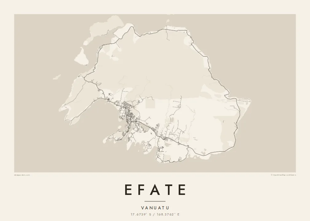
A rounded tropical island ringed by one coastal road, with Port Vila's harbour and lagoons tucked into its southwest corner.




Inki magaala, konoy gaba
Qande inkih tibbixeeh derre baguley table. Kulli qande missoowa caagid—daabbisimta, dirbaabu-le kaadu HD fayla akah.
 Cagalah pixels · 24 × 36″ daabbi fayla
Maxxaacah qeeqa
Tama usuk cagalah daabbi faylak 100% qambaala. Kulli poster — daabbisimta, dirbaabu-le kaadu download geytimta — ni-server-ittal 300 DPI-l ederimta, 7,200 × 10,800 pixels fanah, tokkel iyyi ellee catoy 24 × 36″ daabbi baxsi bahisak raaqu.
Gidarih


Kaarta
Efate is the most populous island of Vanuatu and home to its capital, Port Vila. Its outline is compact and rounded, broken by several large bays and harbours, while the interior is hilly and forested. A sealed ring road follows the coast all the way around the island, linking villages, plantations and beaches in a single loop that shows clearly on the map.
Port Vila spreads along a sheltered harbour on the southwest coast, beside Mele Bay and a series of lagoons, including Erakor and Emten, that reach deep into the town. To the northwest, Havannah Harbour served as a naval anchorage during the Second World War. Chief Roi Mata's Domain, a UNESCO World Heritage site, lies on Efate and the nearby islands of Lelepa and Artok.
An Efate map poster pairs the small, intricate street network of the capital with the long, simple sweep of the ring road. Offshore islands scatter around the coast, and the lagoons around Port Vila add softer, rounded shapes to the composition. It is a map of a capital city and of a quiet island at the same time.
Around the capital, lagoons push inland between streets and headlands. On the poster they create a delicate pattern of water and land at the island's southwest corner.
A single road circles the whole island near the coast. It forms a continuous loop on the map, tying together the capital and the villages along the shore.
A broad, sheltered stretch of water on the northwest coast, protected by offshore islands. It gives the island's outline one of its most distinctive indentations.
Kok tanim ab
Ayro, migaq hinnay kok tan xagar osis; gaba, ballaqa hinnay xiqa soorris.
Free preview qansarissi kee watermark-le. Daabbisimtaan kee HD fayla 300 DPI-l, 7,200 × 10,800 px fanah, watermark maleh ederimta.
Macah Efate
Efate is home to many families in Vanuatu and a place of posting or long stays for others, from aid workers to sailors. A poster of the island captures the capital and its surroundings in one clear shape, easy to recognise from across a room.
You can personalise the title and subtitle, add a date or a neighbourhood, and set the coordinates line. Five styles are available: Classic black & white, Noir, Paper, Blueprint and Sand. Printed posters are shipped from partners in more than 30 countries.
Efate poster orme| Maxxaacah ballaqa | Qeeqa | Faylal |
|---|---|---|
| 30 × 40 cm (11.8 × 15.7″) | 3,543 × 4,724 px | PNG · PDF |
| 29.7 × 42 cm (A3, 11.7 × 16.5″) | 3,508 × 4,961 px | PNG · PDF |
| 42 × 59.4 cm (A2, 16.5 × 23.4″) | 4,961 × 7,016 px | PNG · PDF |
| 45.7 × 61 cm (18 × 24″) | 5,400 × 7,200 px | PNG · PDF |
| 50 × 70 cm (19.7 × 27.6″) | 5,906 × 8,268 px | PNG · PDF |
| 61 × 91.4 cm (24 × 36″) | 7,200 × 10,800 px | PNG · PDF |
Tabbaltah, limo-wayta xaqqa-le ablo 900 px ballaqa le, asta le, iskiriinih keh tan. HD faylal gexsoh inkih addal 8× fanah qeeqa le, poster ballaqa inkih addal meqeh maxxaacimta.
Baxxaqqa qari le qandiy dooriy, tohuk lakal Daabbisimtah Poster — kutuk kee, faxximek, dirbaabu — hinnay HD Digital Fayla dooru. Checkout inki wagitti geytima, kaadu ku-orme page keenih adissa akke waqdi caagoy kummite.
Usuk 200 gsm-le catam kutuk warqatal, lica katiy caagitte {printFrom}-ik hane ayta 30 × 40 cm-ik 24 × 36″ fanah, xaagu keenil warreeh.
Ee. Sarrah-le dirbaabu doori — bad, gudduc, oak-le hinnay bad-madabuy. Usuk finqisiimam ellee sange qarab-le kaadu qari umukku iyya keenih taagu. Dirbaabu-le poster {framedFrom}-ik hane, xaagu keenil warreeh.
Xaagu addunyal inkih cisab-le. Kulli poster 30+ ummattak ni-daabbi-mara mananih xayyoysa kaadu 3–7 caagu-ayróh fanah geeytima. Ku-orme kee xaagu tarikiy My Orders addal ablitta.
Geytimeek 14 ayróy addal foto naah rubbaay, cisab-le daabbisiynah hinnay ku-lacay gacisnaah.
Ee. Tama page-l edito addal, migaaq, subtitle kee coordinates sarrah faxxem fanah badal, kaadu qande kee katiy doori. Daabbisimtah, dirbaabu-le kaadu digital orme inkih ku-design cagalah yekkelen.
$9 bacisak 300 DPI PNG kee daabbisimtah adissime PDF fayla lica katiy inkih, watermark maleh, ayyi meki daabbisimtah geeytitta. Cisab makkoysemty ana? Awqak, watermark-le free preview download-eh.
