Rebuilt old town
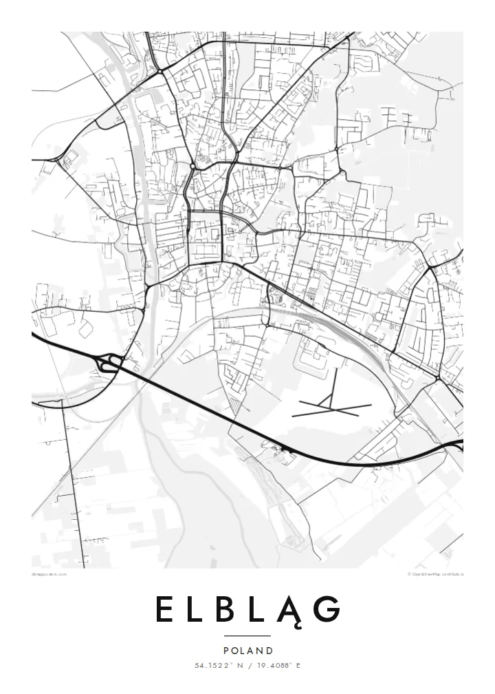
The medieval street plan was kept when the old town was reconstructed. The poster therefore shows the original grid of narrow parallel streets beside the river.
Qeeqabak kaartah poster · Poland
54.1522° N / 19.4088° E
A rebuilt Hanseatic town on the Elbląg River, close to the Vistula Lagoon and the start of a famous canal.


Inki magaala, konoy gaba
Qande inkih tibbixeeh derre baguley table. Kulli qande missoowa caagid—daabbisimta, dirbaabu-le kaadu HD fayla akah.
 Cagalah pixels · 24 × 36″ daabbi fayla
Maxxaacah qeeqa
Tama usuk cagalah daabbi faylak 100% qambaala. Kulli poster — daabbisimta, dirbaabu-le kaadu download geytimta — ni-server-ittal 300 DPI-l ederimta, 7,200 × 10,800 pixels fanah, tokkel iyyi ellee catoy 24 × 36″ daabbi baxsi bahisak raaqu.
Gidarih


Kaarta
Elbląg lies in northern Poland, on the Elbląg River a short distance from where it flows into the Vistula Lagoon. The river runs along the western side of the old town, and the map shows a compact medieval core beside it, surrounded by wider streets and housing districts. Higher ground rises to the north-east, while the low, flat Żuławy delta stretches away to the west.
The Teutonic Order founded Elbląg in the thirteenth century, and it became a prosperous Hanseatic port. The old town was almost entirely destroyed in 1945. Since the 1980s it has been rebuilt using an approach known as retroversion: new buildings on the original plots echo the proportions of the historic ones. The city is also the starting point of the Elbląg Canal.
An Elbląg map poster traces the river, the medieval grid of the rebuilt old town and the modern city around them, with water and lowland opening to the west. The historic plan was kept even though the buildings were not, so the poster records a street pattern that has lasted for centuries.
The medieval street plan was kept when the old town was reconstructed. The poster therefore shows the original grid of narrow parallel streets beside the river.
The river runs past the old town and on to the Vistula Lagoon. It forms the western edge of the historic centre and a strong line through the map.
The canal that begins here is known for its inclined planes, where boats travel overland on rail carriages to cross the height differences between lakes.
Kok tanim ab
Ayro, migaq hinnay kok tan xagar osis; gaba, ballaqa hinnay xiqa soorris.
Free preview qansarissi kee watermark-le. Daabbisimtaan kee HD fayla 300 DPI-l, 7,200 × 10,800 px fanah, watermark maleh ederimta.
Macah Elbląg
Elbląg holds family stories from many directions, from its Hanseatic and German past to its Polish post-war settlement. A map of the city marks that layered history quietly, and it suits anyone who has lived by the river or sailed the canal.
You can personalise the title, subtitle and coordinates, and choose from five styles: Classic black & white, Noir, Paper, Blueprint or Sand. The $9 download covers all six sizes, and a free 900 px preview lets you check the design first.
Elbląg poster orme| Maxxaacah ballaqa | Qeeqa | Faylal |
|---|---|---|
| 30 × 40 cm (11.8 × 15.7″) | 3,543 × 4,724 px | PNG · PDF |
| 29.7 × 42 cm (A3, 11.7 × 16.5″) | 3,508 × 4,961 px | PNG · PDF |
| 42 × 59.4 cm (A2, 16.5 × 23.4″) | 4,961 × 7,016 px | PNG · PDF |
| 45.7 × 61 cm (18 × 24″) | 5,400 × 7,200 px | PNG · PDF |
| 50 × 70 cm (19.7 × 27.6″) | 5,906 × 8,268 px | PNG · PDF |
| 61 × 91.4 cm (24 × 36″) | 7,200 × 10,800 px | PNG · PDF |
Tabbaltah, limo-wayta xaqqa-le ablo 900 px ballaqa le, asta le, iskiriinih keh tan. HD faylal gexsoh inkih addal 8× fanah qeeqa le, poster ballaqa inkih addal meqeh maxxaacimta.
Baxxaqqa qari le qandiy dooriy, tohuk lakal Daabbisimtah Poster — kutuk kee, faxximek, dirbaabu — hinnay HD Digital Fayla dooru. Checkout inki wagitti geytima, kaadu ku-orme page keenih adissa akke waqdi caagoy kummite.
Usuk 200 gsm-le catam kutuk warqatal, lica katiy caagitte $39-ik hane ayta 30 × 40 cm-ik 24 × 36″ fanah, xaagu keenil warreeh.
Ee. Sarrah-le dirbaabu doori — bad, gudduc, oak-le hinnay bad-madabuy. Usuk finqisiimam ellee sange qarab-le kaadu qari umukku iyya keenih taagu. Dirbaabu-le poster $99-ik hane, xaagu keenil warreeh.
Shipping is free worldwide. Each poster is printed by the nearest of our print partners in 30+ countries and usually arrives in 3–7 business days. You can follow the status and tracking under My Orders. A few countries take 2–5 weeks, and where we don't ship yet, the site tells you before you pay.
Geytimeek 14 ayróy addal foto naah rubbaay, cisab-le daabbisiynah hinnay ku-lacay gacisnaah.
Ee. Tama page-l edito addal, migaaq, subtitle kee coordinates sarrah faxxem fanah badal, kaadu qande kee katiy doori. Daabbisimtah, dirbaabu-le kaadu digital orme inkih ku-design cagalah yekkelen.
$9 bacisak 300 DPI PNG kee daabbisimtah adissime PDF fayla lica katiy inkih, watermark maleh, ayyi meki daabbisimtah geeytitta. Cisab makkoysemty ana? Awqak, watermark-le free preview download-eh.
Xayyo
