Mount Kinka
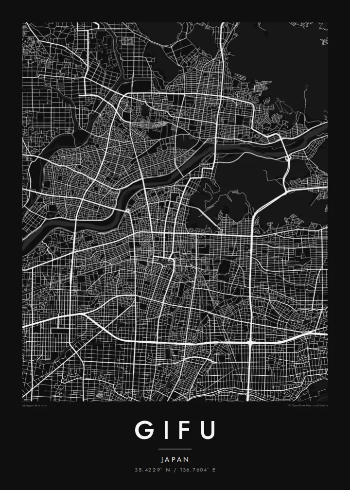
A forested peak rising straight out of the city's northeastern edge, left almost untouched by roads. On the map it forms a large open shape, with the castle at its summit.
Qeeqabak kaartah poster · Japan
35.4229° N / 136.7604° E
A flat city on the Nobi Plain, pinned between the curving Nagara River and the steep wooded mass of Mount Kinka.



Inki magaala, konoy gaba
Qande inkih tibbixeeh derre baguley table. Kulli qande missoowa caagid—daabbisimta, dirbaabu-le kaadu HD fayla akah.
 Cagalah pixels · 24 × 36″ daabbi fayla
Maxxaacah qeeqa
Tama usuk cagalah daabbi faylak 100% qambaala. Kulli poster — daabbisimta, dirbaabu-le kaadu download geytimta — ni-server-ittal 300 DPI-l ederimta, 7,200 × 10,800 pixels fanah, tokkel iyyi ellee catoy 24 × 36″ daabbi baxsi bahisak raaqu.
Gidarih


Kaarta
Gifu sits where the mountains of central Japan give way to the Nobi Plain, and the map shows that edge clearly. To the north, the Nagara River sweeps past in a clean, wide arc, and Mount Kinka rises abruptly beside it as a dark, almost roadless island of forest. South of the river, the city spreads in a regular grid of streets toward the main railway station.
Gifu Castle stands on the summit of Mount Kinka, reached by ropeway, and the name of the city itself is traditionally credited to Oda Nobunaga, who took the castle in the sixteenth century. On summer nights the Nagara hosts ukai, cormorant fishing by torchlight from wooden boats, a practice the city has kept alive for well over a thousand years.
A Gifu map poster captures the contrast between two textures: the precise, even grid of the lowland city and the blank, organic outline of the mountain and river on its northern edge. Smaller streams and channels thread through the southern districts, and the whole composition reads as a meeting of plain, water and hill in a single frame.
A forested peak rising straight out of the city's northeastern edge, left almost untouched by roads. On the map it forms a large open shape, with the castle at its summit.
The river runs clear and wide along the north of the centre and is known for its summer cormorant fishing. Its long curve gives the poster a natural upper boundary.
Around JR Gifu Station the streets settle into an orderly grid, the densest part of the map and the commercial core of the city.
Kok tanim ab
Ayro, migaq hinnay kok tan xagar osis; gaba, ballaqa hinnay xiqa soorris.
Free preview qansarissi kee watermark-le. Daabbisimtaan kee HD fayla 300 DPI-l, 7,200 × 10,800 px fanah, watermark maleh ederimta.
Macah Gifu
For many, Gifu means summers by the river and the ropeway ride up to the castle. A map of the city holds that geography in one view and suits anyone with family ties to the prefecture or good memories of a trip through central Japan.
You can personalise the title, subtitle and coordinates line, for example with a home address or the date of a visit. The poster comes in five styles, from Classic black & white and Noir to Paper, Blueprint and Sand, as a digital file or printed on matte paper.
Gifu poster orme| Maxxaacah ballaqa | Qeeqa | Faylal |
|---|---|---|
| 30 × 40 cm11.8 × 15.7″ | 3,543 × 4,724 px | PNG · PDF |
| 29.7 × 42 cm (A3)11.7 × 16.5″ | 3,508 × 4,961 px | PNG · PDF |
| 42 × 59.4 cm (A2)16.5 × 23.4″ | 4,961 × 7,016 px | PNG · PDF |
| 45.7 × 61 cm18 × 24″ | 5,400 × 7,200 px | PNG · PDF |
| 50 × 70 cm19.7 × 27.6″ | 5,906 × 8,268 px | PNG · PDF |
| 61 × 91.4 cm24 × 36″ | 7,200 × 10,800 px | PNG · PDF |
Tabbaltah, limo-wayta xaqqa-le ablo 900 px ballaqa le, asta le, iskiriinih keh tan. HD faylal gexsoh inkih addal 8× fanah qeeqa le, poster ballaqa inkih addal meqeh maxxaacimta.
Baxxaqqa qari le qandiy dooriy, tohuk lakal Daabbisimtah Poster — kutuk kee, faxximek, dirbaabu — hinnay HD Digital Fayla dooru. Checkout inki wagitti geytima, kaadu ku-orme page keenih adissa akke waqdi caagoy kummite.
Usuk 200 gsm-le catam kutuk warqatal, lica katiy caagitte $39-ik hane ayta 30 × 40 cm-ik 24 × 36″ fanah, xaagu keenil warreeh.
Ee. Sarrah-le dirbaabu doori — bad, gudduc, oak-le hinnay bad-madabuy. Usuk finqisiimam ellee sange qarab-le kaadu qari umukku iyya keenih taagu. Dirbaabu-le poster $99-ik hane, xaagu keenil warreeh.
Dirsa 60+ baaxoh bilsa. Poster kasa 30+ baaxoh nel print kaadu yan kee dirgeh kaxxa kee tanah printa, kee 3–7 xaqu ayyaamah yaaxigeeh. Xaaloo kee tracking "Ac Order" gexsitam. Kaadu baaxo 2–5 isbuuc yaaxigeeh, nanu dirsi yanin baaxoh sajiitah site ku kalah tekkeh.
Geytimeek 14 ayróy addal foto naah rubbaay, cisab-le daabbisiynah hinnay ku-lacay gacisnaah.
Ee. Tama page-l edito addal, migaaq, subtitle kee coordinates sarrah faxxem fanah badal, kaadu qande kee katiy doori. Daabbisimtah, dirbaabu-le kaadu digital orme inkih ku-design cagalah yekkelen.
$9 bacisak 300 DPI PNG kee daabbisimtah adissime PDF fayla lica katiy inkih, watermark maleh, ayyi meki daabbisimtah geeytitta. Cisab makkoysemty ana? Awqak, watermark-le free preview download-eh.
Xayyo
