Suomenlinna sea fortress
Built in the eighteenth century across several linked islands at the harbour entrance, its angular bastions and irregular walls form one of the most distinctive outlines on the whole map.
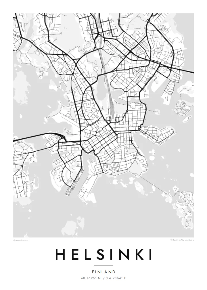
Qeeqabak kaartah poster · Finland
60.1695° N / 24.9354° E
A granite peninsula that breaks into bays and islands, with a compact grid at its tip and sea on three sides


Inki magaala, konoy gaba
Qande inkih tibbixeeh derre baguley table. Kulli qande missoowa caagid—daabbisimta, dirbaabu-le kaadu HD fayla akah.
 Cagalah pixels · 24 × 36″ daabbi fayla
Maxxaacah qeeqa
Tama usuk cagalah daabbi faylak 100% qambaala. Kulli poster — daabbisimta, dirbaabu-le kaadu download geytimta — ni-server-ittal 300 DPI-l ederimta, 7,200 × 10,800 pixels fanah, tokkel iyyi ellee catoy 24 × 36″ daabbi baxsi bahisak raaqu.
Gidarih


Kaarta
Helsinki sits on a peninsula that pushes into the Gulf of Finland, and from above its coastline matters most. The land breaks into coves, headlands and more than three hundred islands, so the city carries on past the point where the streets stop. Inland the pattern loosens into leafy districts and a long strip of forest, the Central Park, which runs north almost unbroken from Töölö Bay towards the city's edge.
The centre is orderly. After Helsinki was named capital in 1812, the architect Carl Ludvig Engel laid out a neoclassical core around Senate Square. The Esplanadi park strip still runs west from the market harbour as straight as a ruler. Around it, blocks of stone apartment buildings form a tight grid that reads cleanly in black and white. Rail yards and the long curve of the harbour break it up.
A Helsinki map poster shows this balance of order and irregularity: a precise centre, a coastline with almost no straight lines, and water in every gap. Offshore, the island fortress of Suomenlinna, a UNESCO World Heritage Site, spreads across a cluster of connected islets at the harbour mouth. Ferries, bridges and causeways join the rest together, and each one leaves a thin line on the page.
Built in the eighteenth century across several linked islands at the harbour entrance, its angular bastions and irregular walls form one of the most distinctive outlines on the whole map.
Senate Square and the Esplanadi park avenue sit just back from the South Harbour. They give the densest streets a clear, symmetrical anchor that stands out at every print size.
A band of forest about ten kilometres long runs north from the inner city. It leaves a wide, pale ribbon between the residential districts on either side.
Kok tanim ab
Ayro, migaq hinnay kok tan xagar osis; gaba, ballaqa hinnay xiqa soorris.
Free preview qansarissi kee watermark-le. Daabbisimtaan kee HD fayla 300 DPI-l, 7,200 × 10,800 px fanah, watermark maleh ederimta.
Macah Helsinki
People hang Helsinki for a flat near Töölö, summers on the islands, or an exchange year that turned into something longer. The map holds all of it at once: the harbour, the grid and the sea. Add a title, a date or a line of coordinates to mark which chapter it belongs to.
The coastline works especially well in Noir, where the water turns dark and the islands look like scattered light, or in Blueprint for a cooler, technical look. Classic black & white, Paper and Sand are available too. Download the HD files for $9 or order a matte print, framed if you like.
Helsinki poster orme| Maxxaacah ballaqa | Qeeqa | Faylal |
|---|---|---|
| 30 × 40 cm (11.8 × 15.7″) | 3,543 × 4,724 px | PNG · PDF |
| 29.7 × 42 cm (A3, 11.7 × 16.5″) | 3,508 × 4,961 px | PNG · PDF |
| 42 × 59.4 cm (A2, 16.5 × 23.4″) | 4,961 × 7,016 px | PNG · PDF |
| 45.7 × 61 cm (18 × 24″) | 5,400 × 7,200 px | PNG · PDF |
| 50 × 70 cm (19.7 × 27.6″) | 5,906 × 8,268 px | PNG · PDF |
| 61 × 91.4 cm (24 × 36″) | 7,200 × 10,800 px | PNG · PDF |
Tabbaltah, limo-wayta xaqqa-le ablo 900 px ballaqa le, asta le, iskiriinih keh tan. HD faylal gexsoh inkih addal 8× fanah qeeqa le, poster ballaqa inkih addal meqeh maxxaacimta.
Baxxaqqa qari le qandiy dooriy, tohuk lakal Daabbisimtah Poster — kutuk kee, faxximek, dirbaabu — hinnay HD Digital Fayla dooru. Checkout inki wagitti geytima, kaadu ku-orme page keenih adissa akke waqdi caagoy kummite.
Usuk 200 gsm-le catam kutuk warqatal, lica katiy caagitte $39-ik hane ayta 30 × 40 cm-ik 24 × 36″ fanah, xaagu keenil warreeh.
Ee. Sarrah-le dirbaabu doori — bad, gudduc, oak-le hinnay bad-madabuy. Usuk finqisiimam ellee sange qarab-le kaadu qari umukku iyya keenih taagu. Dirbaabu-le poster $99-ik hane, xaagu keenil warreeh.
Shipping is free worldwide. Each poster is printed by the nearest of our print partners in 30+ countries and usually arrives in 3–7 business days. You can follow the status and tracking under My Orders. A few countries take 2–5 weeks, and where we don't ship yet, the site tells you before you pay.
Geytimeek 14 ayróy addal foto naah rubbaay, cisab-le daabbisiynah hinnay ku-lacay gacisnaah.
Ee. Tama page-l edito addal, migaaq, subtitle kee coordinates sarrah faxxem fanah badal, kaadu qande kee katiy doori. Daabbisimtah, dirbaabu-le kaadu digital orme inkih ku-design cagalah yekkelen.
$9 bacisak 300 DPI PNG kee daabbisimtah adissime PDF fayla lica katiy inkih, watermark maleh, ayyi meki daabbisimtah geeytitta. Cisab makkoysemty ana? Awqak, watermark-le free preview download-eh.
Xayyo
