Huai River
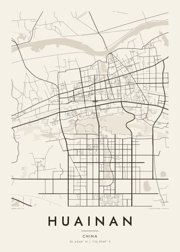
The river runs along the northern edge of the city, broad and slowly curving. Bridges and embankments mark where the urban area meets the water.
Qeeqabak kaartah poster · China
32.6264° N / 116.9969° E
A coal city stretched along the southern bank of the Huai River, its districts strung out between the water and low hills.




Inki magaala, konoy gaba
Qande inkih tibbixeeh derre baguley table. Kulli qande missoowa caagid—daabbisimta, dirbaabu-le kaadu HD fayla akah.
 Cagalah pixels · 24 × 36″ daabbi fayla
Maxxaacah qeeqa
Tama usuk cagalah daabbi faylak 100% qambaala. Kulli poster — daabbisimta, dirbaabu-le kaadu download geytimta — ni-server-ittal 300 DPI-l ederimta, 7,200 × 10,800 pixels fanah, tokkel iyyi ellee catoy 24 × 36″ daabbi baxsi bahisak raaqu.
Gidarih


Kaarta
Huainan grew in the twentieth century as a coal-mining city in central Anhui, and its map reflects that origin. It did not spread from a single old centre. Instead it developed around separate mining areas along the southern bank of the Huai River, so its districts stretch out in a long east–west line with open land and water between them.
The Huai River is the clearest line on the map, a wide, curving waterway that marks the traditional division between northern and southern China. Mining subsidence has created lakes and wetlands in several parts of the area. Some have been turned into parks, adding irregular open shapes to the street pattern.
The city's name is linked to Liu An, Prince of Huainan in the Han dynasty and compiler of the Huainanzi, and tradition credits the region with the invention of tofu. Nearby Bagong Mountain is associated with the Battle of the Fei River. A Huainan map poster shows a city defined by its river and its industry.
The river runs along the northern edge of the city, broad and slowly curving. Bridges and embankments mark where the urban area meets the water.
Separate urban districts line up from east to west, joined by long main roads. The map's elongated outline comes from mining history rather than a planned centre.
Lakes that formed over old mine workings appear as irregular open areas among the streets. Some are now landscaped, a distinctive feature of coal cities on the plain.
Kok tanim ab
Ayro, migaq hinnay kok tan xagar osis; gaba, ballaqa hinnay xiqa soorris.
Free preview qansarissi kee watermark-le. Daabbisimtaan kee HD fayla 300 DPI-l, 7,200 × 10,800 px fanah, watermark maleh ederimta.
Macah Huainan
Huainan is hung by people who grew up with its mines, its river and its tofu dishes. For families who have lived there for generations, the map records a place that has changed a great deal and keeps changing.
Choose a title and subtitle, and keep or edit the coordinates line. Classic black & white, Noir, Paper, Blueprint and Sand are all available. The $9 digital files come in six sizes, and a free watermarked preview lets you check the framing first.
Huainan poster orme| Maxxaacah ballaqa | Qeeqa | Faylal |
|---|---|---|
| 30 × 40 cm11.8 × 15.7″ | 3,543 × 4,724 px | PNG · PDF |
| 29.7 × 42 cm (A3)11.7 × 16.5″ | 3,508 × 4,961 px | PNG · PDF |
| 42 × 59.4 cm (A2)16.5 × 23.4″ | 4,961 × 7,016 px | PNG · PDF |
| 45.7 × 61 cm18 × 24″ | 5,400 × 7,200 px | PNG · PDF |
| 50 × 70 cm19.7 × 27.6″ | 5,906 × 8,268 px | PNG · PDF |
| 61 × 91.4 cm24 × 36″ | 7,200 × 10,800 px | PNG · PDF |
Tabbaltah, limo-wayta xaqqa-le ablo 900 px ballaqa le, asta le, iskiriinih keh tan. HD faylal gexsoh inkih addal 8× fanah qeeqa le, poster ballaqa inkih addal meqeh maxxaacimta.
Baxxaqqa qari le qandiy dooriy, tohuk lakal Daabbisimtah Poster — kutuk kee, faxximek, dirbaabu — hinnay HD Digital Fayla dooru. Checkout inki wagitti geytima, kaadu ku-orme page keenih adissa akke waqdi caagoy kummite.
Usuk 200 gsm-le catam kutuk warqatal, lica katiy caagitte $39-ik hane ayta 30 × 40 cm-ik 24 × 36″ fanah, xaagu keenil warreeh.
Ee. Sarrah-le dirbaabu doori — bad, gudduc, oak-le hinnay bad-madabuy. Usuk finqisiimam ellee sange qarab-le kaadu qari umukku iyya keenih taagu. Dirbaabu-le poster $99-ik hane, xaagu keenil warreeh.
Dirsa 60+ baaxoh bilsa. Poster kasa 30+ baaxoh nel print kaadu yan kee dirgeh kaxxa kee tanah printa, kee 3–7 xaqu ayyaamah yaaxigeeh. Xaaloo kee tracking "Ac Order" gexsitam. Kaadu baaxo 2–5 isbuuc yaaxigeeh, nanu dirsi yanin baaxoh sajiitah site ku kalah tekkeh.
Geytimeek 14 ayróy addal foto naah rubbaay, cisab-le daabbisiynah hinnay ku-lacay gacisnaah.
Ee. Tama page-l edito addal, migaaq, subtitle kee coordinates sarrah faxxem fanah badal, kaadu qande kee katiy doori. Daabbisimtah, dirbaabu-le kaadu digital orme inkih ku-design cagalah yekkelen.
$9 bacisak 300 DPI PNG kee daabbisimtah adissime PDF fayla lica katiy inkih, watermark maleh, ayyi meki daabbisimtah geeytitta. Cisab makkoysemty ana? Awqak, watermark-le free preview download-eh.
Xayyo
