Central crossroads
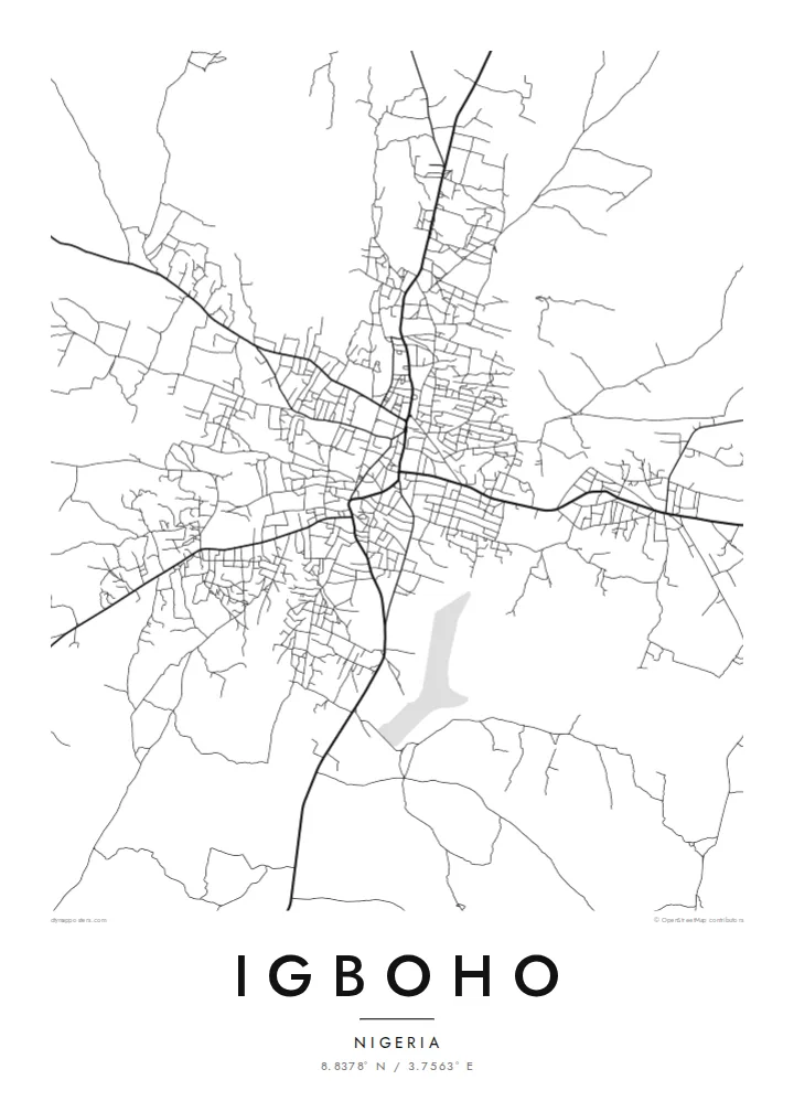
The main roads into town converge near the older core. This junction is the visual anchor of the map, and the rest of Igboho grows out from it in every direction.
Qeeqabak kaartah poster · Nigeria
8.8378° N / 3.7563° E
A savanna town of red-earth roads and scattered compounds, its streets radiating loosely across the open Oke-Ogun plains.


Inki magaala, konoy gaba
Qande inkih tibbixeeh derre baguley table. Kulli qande missoowa caagid—daabbisimta, dirbaabu-le kaadu HD fayla akah.
 Cagalah pixels · 24 × 36″ daabbi fayla
Maxxaacah qeeqa
Tama usuk cagalah daabbi faylak 100% qambaala. Kulli poster — daabbisimta, dirbaabu-le kaadu download geytimta — ni-server-ittal 300 DPI-l ederimta, 7,200 × 10,800 pixels fanah, tokkel iyyi ellee catoy 24 × 36″ daabbi baxsi bahisak raaqu.
Gidarih


Kaarta
Igboho is in the Oke-Ogun area of northern Oyo State. Here the forest thins into open savanna, and the towns sit far apart along long, straight roads. From above, the town is a loose, organic spread rather than a planned grid. Main roads meet near the old centre, and around them clusters of compounds and smaller lanes fan out, gradually giving way to farmland and bush.
The town has a firm place in Yoruba history. When the Oyo kingdom was driven from its capital, Oyo-Ile, Igboho became the seat of the Alaafins for a period, and several of them are remembered as having been buried there. Today it is the headquarters of Oorelope Local Government Area, and it is a market and farming centre for the surrounding countryside.
An Igboho map poster shows a town that has grown outward from its crossroads. Seen from above, the roads cut clean diagonals across the plain, and the small streets between them form an irregular, hand-drawn texture. With so few large rivers or hills in the frame, the pattern of settlement itself becomes the subject, rendered in fine lines on open space.
The main roads into town converge near the older core. This junction is the visual anchor of the map, and the rest of Igboho grows out from it in every direction.
Between the main roads, short lanes and paths link family compounds in an irregular weave. It is a dense, organic texture that contrasts with the straight regional highways.
Beyond the built-up area the map opens into farmland and savanna. The surrounding space gives the town clear edges and a strong silhouette on the page.
Kok tanim ab
Ayro, migaq hinnay kok tan xagar osis; gaba, ballaqa hinnay xiqa soorris.
Free preview qansarissi kee watermark-le. Daabbisimtaan kee HD fayla 300 DPI-l, 7,200 × 10,800 px fanah, watermark maleh ederimta.
Macah Igboho
For people from Igboho, and for its many families living elsewhere in Nigeria and abroad, a map of the town is a direct link to home, to the compound, the market and the roads that lead back to them.
Personalise the title, subtitle and coordinates line with a family name, a quarter or a meaningful date, and pick one of five styles: Classic black and white, Noir, Paper, Blueprint or Sand. Sand suits the warm savanna setting.
Igboho poster orme| Maxxaacah ballaqa | Qeeqa | Faylal |
|---|---|---|
| 30 × 40 cm (11.8 × 15.7″) | 3,543 × 4,724 px | PNG · PDF |
| 29.7 × 42 cm (A3, 11.7 × 16.5″) | 3,508 × 4,961 px | PNG · PDF |
| 42 × 59.4 cm (A2, 16.5 × 23.4″) | 4,961 × 7,016 px | PNG · PDF |
| 45.7 × 61 cm (18 × 24″) | 5,400 × 7,200 px | PNG · PDF |
| 50 × 70 cm (19.7 × 27.6″) | 5,906 × 8,268 px | PNG · PDF |
| 61 × 91.4 cm (24 × 36″) | 7,200 × 10,800 px | PNG · PDF |
Tabbaltah, limo-wayta xaqqa-le ablo 900 px ballaqa le, asta le, iskiriinih keh tan. HD faylal gexsoh inkih addal 8× fanah qeeqa le, poster ballaqa inkih addal meqeh maxxaacimta.
Baxxaqqa qari le qandiy dooriy, tohuk lakal Daabbisimtah Poster — kutuk kee, faxximek, dirbaabu — hinnay HD Digital Fayla dooru. Checkout inki wagitti geytima, kaadu ku-orme page keenih adissa akke waqdi caagoy kummite.
Usuk 200 gsm-le catam kutuk warqatal, lica katiy caagitte {printFrom}-ik hane ayta 30 × 40 cm-ik 24 × 36″ fanah, xaagu keenil warreeh.
Ee. Sarrah-le dirbaabu doori — bad, gudduc, oak-le hinnay bad-madabuy. Usuk finqisiimam ellee sange qarab-le kaadu qari umukku iyya keenih taagu. Dirbaabu-le poster {framedFrom}-ik hane, xaagu keenil warreeh.
Xaagu addunyal inkih cisab-le. Kulli poster 30+ ummattak ni-daabbi-mara mananih xayyoysa kaadu 3–7 caagu-ayróh fanah geeytima. Ku-orme kee xaagu tarikiy My Orders addal ablitta.
Geytimeek 14 ayróy addal foto naah rubbaay, cisab-le daabbisiynah hinnay ku-lacay gacisnaah.
Ee. Tama page-l edito addal, migaaq, subtitle kee coordinates sarrah faxxem fanah badal, kaadu qande kee katiy doori. Daabbisimtah, dirbaabu-le kaadu digital orme inkih ku-design cagalah yekkelen.
$9 bacisak 300 DPI PNG kee daabbisimtah adissime PDF fayla lica katiy inkih, watermark maleh, ayyi meki daabbisimtah geeytitta. Cisab makkoysemty ana? Awqak, watermark-le free preview download-eh.
Xayyo
