Parasio quarter
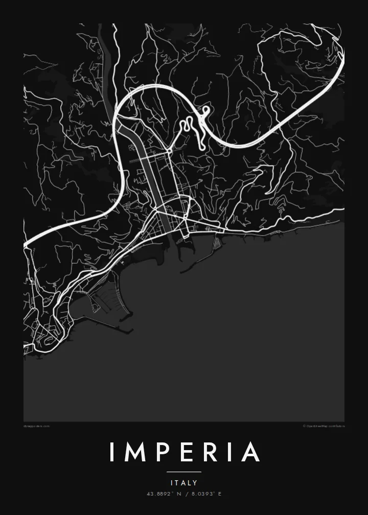
Porto Maurizio's old quarter crowns its promontory with a dense tangle of stepped lanes and alleys, one of the most intricate patches of streets on the whole poster.
Qeeqabak kaartah poster · Italy
43.8892° N / 8.0393° E
Two old towns on the Ligurian coast, Porto Maurizio and Oneglia, joined across the mouth of the Impero river.



Inki magaala, konoy gaba
Qande inkih tibbixeeh derre baguley table. Kulli qande missoowa caagid—daabbisimta, dirbaabu-le kaadu HD fayla akah.
 Cagalah pixels · 24 × 36″ daabbi fayla
Maxxaacah qeeqa
Tama usuk cagalah daabbi faylak 100% qambaala. Kulli poster — daabbisimta, dirbaabu-le kaadu download geytimta — ni-server-ittal 300 DPI-l ederimta, 7,200 × 10,800 pixels fanah, tokkel iyyi ellee catoy 24 × 36″ daabbi baxsi bahisak raaqu.
Gidarih


Kaarta
Imperia was created in 1923 by joining two separate towns on the western Riviera, Porto Maurizio and Oneglia, together with several smaller villages. The Impero river, which gave the new city its name, flows between them to the sea. A century later the two halves still have distinct characters, and on a map they read as two centres rather than one.
Porto Maurizio climbs a rocky promontory. Its old quarter, the Parasio, is a knot of steep lanes around the hilltop, and the large neoclassical Basilica of San Maurizio stands close by. Oneglia, to the east, is flatter and more regular, with an arcaded street, a working harbour and a history tied to olive oil and pasta-making. Terraced olive groves cover the hills above both.
An Imperia map poster brings out that double structure very clearly. Two harbours, two old centres and a river mouth between them sit along a curving stretch of Mediterranean coast, with steep hinterland behind. It is a thoughtful choice for anyone who has spent summers on the Riviera di Ponente or has family roots in either town.
Porto Maurizio's old quarter crowns its promontory with a dense tangle of stepped lanes and alleys, one of the most intricate patches of streets on the whole poster.
Oneglia's port and the arcaded streets behind it form a flatter, more orderly pattern, historically linked to the olive oil trade that shaped the town's economy.
The short river that gave the city its name reaches the sea between the two towns. It is a clear dividing line that explains Imperia's unusual two-centred shape.
Kok tanim ab
Ayro, migaq hinnay kok tan xagar osis; gaba, ballaqa hinnay xiqa soorris.
Free preview qansarissi kee watermark-le. Daabbisimtaan kee HD fayla 300 DPI-l, 7,200 × 10,800 px fanah, watermark maleh ederimta.
Macah Imperia
Imperia rewards people who know it well: the walk between the two harbours, the climb into the Parasio, the olive terraces above the coast. A map poster keeps all of those places together in one clean, legible image.
You can title it Imperia or name one of its two halves, add a date or a line of your own, and choose from five styles. The digital files come in six sizes, including 50×70 cm, A2 and 24×36″, with no watermark.
Imperia poster orme| Maxxaacah ballaqa | Qeeqa | Faylal |
|---|---|---|
| 30 × 40 cm (11.8 × 15.7″) | 3,543 × 4,724 px | PNG · PDF |
| 29.7 × 42 cm (A3, 11.7 × 16.5″) | 3,508 × 4,961 px | PNG · PDF |
| 42 × 59.4 cm (A2, 16.5 × 23.4″) | 4,961 × 7,016 px | PNG · PDF |
| 45.7 × 61 cm (18 × 24″) | 5,400 × 7,200 px | PNG · PDF |
| 50 × 70 cm (19.7 × 27.6″) | 5,906 × 8,268 px | PNG · PDF |
| 61 × 91.4 cm (24 × 36″) | 7,200 × 10,800 px | PNG · PDF |
Tabbaltah, limo-wayta xaqqa-le ablo 900 px ballaqa le, asta le, iskiriinih keh tan. HD faylal gexsoh inkih addal 8× fanah qeeqa le, poster ballaqa inkih addal meqeh maxxaacimta.
Baxxaqqa qari le qandiy dooriy, tohuk lakal Daabbisimtah Poster — kutuk kee, faxximek, dirbaabu — hinnay HD Digital Fayla dooru. Checkout inki wagitti geytima, kaadu ku-orme page keenih adissa akke waqdi caagoy kummite.
Usuk 200 gsm-le catam kutuk warqatal, lica katiy caagitte {printFrom}-ik hane ayta 30 × 40 cm-ik 24 × 36″ fanah, xaagu keenil warreeh.
Ee. Sarrah-le dirbaabu doori — bad, gudduc, oak-le hinnay bad-madabuy. Usuk finqisiimam ellee sange qarab-le kaadu qari umukku iyya keenih taagu. Dirbaabu-le poster {framedFrom}-ik hane, xaagu keenil warreeh.
Xaagu addunyal inkih cisab-le. Kulli poster 30+ ummattak ni-daabbi-mara mananih xayyoysa kaadu 3–7 caagu-ayróh fanah geeytima. Ku-orme kee xaagu tarikiy My Orders addal ablitta.
Geytimeek 14 ayróy addal foto naah rubbaay, cisab-le daabbisiynah hinnay ku-lacay gacisnaah.
Ee. Tama page-l edito addal, migaaq, subtitle kee coordinates sarrah faxxem fanah badal, kaadu qande kee katiy doori. Daabbisimtah, dirbaabu-le kaadu digital orme inkih ku-design cagalah yekkelen.
$9 bacisak 300 DPI PNG kee daabbisimtah adissime PDF fayla lica katiy inkih, watermark maleh, ayyi meki daabbisimtah geeytitta. Cisab makkoysemty ana? Awqak, watermark-le free preview download-eh.
