Irrigation ponds
Dozens of small reservoirs sit among the northern neighbourhoods. They are old farming ponds of the Senshu plain and read as quiet, solid shapes inside the street pattern.
Qeeqabak kaartah poster · Japan
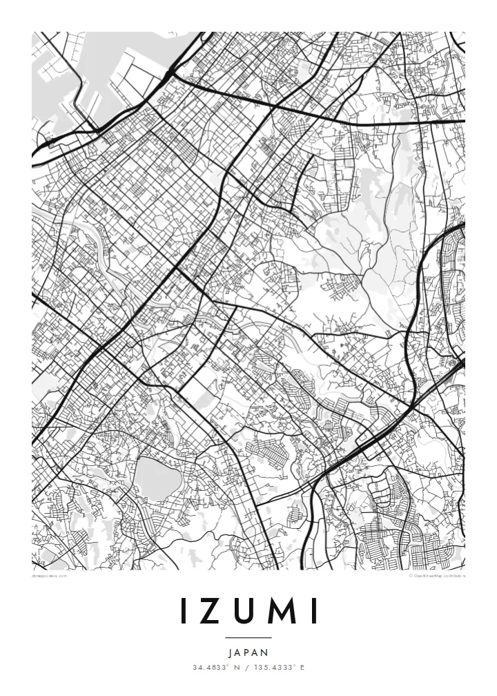
34.4833° N / 135.4333° E
A long inland city climbing from the flat Senshu plain toward the wooded Izumi Mountains on the Wakayama border


Inki magaala, konoy gaba
Qande inkih tibbixeeh derre baguley table. Kulli qande missoowa caagid—daabbisimta, dirbaabu-le kaadu HD fayla akah.
 Cagalah pixels · 24 × 36″ daabbi fayla
Maxxaacah qeeqa
Tama usuk cagalah daabbi faylak 100% qambaala. Kulli poster — daabbisimta, dirbaabu-le kaadu download geytimta — ni-server-ittal 300 DPI-l ederimta, 7,200 × 10,800 pixels fanah, tokkel iyyi ellee catoy 24 × 36″ daabbi baxsi bahisak raaqu.
Gidarih


Kaarta
Izumi stretches across southern Osaka Prefecture in the Senshu area, between Sakai and Kishiwada. It is an inland city, so on a map it runs from the flat plain toward the hills instead of along the bay. The northern districts carry the dense street network of the Osaka suburbs. Further south the lines loosen into valleys, terraced slopes and the forested ridges of the Izumi Mountains, which mark the prefectural border.
Rail shapes the city. The JR Hanwa Line crosses the older western districts, and the Semboku Rapid Railway ends at Izumi-Chūō, near the newer planned housing areas. Across the plain, small irrigation ponds are scattered between neighbourhoods. These reservoirs are typical of the Senshu landscape and appear on the map as neat, rounded shapes set among the streets.
An Izumi map poster covers more than a commuter suburb. The Ikegami-Sone site, one of the best-known Yayoi-period settlements in Japan, lies partly within the city. High in the southern hills stands Sefuku-ji on Mount Makinoo, a stop on the Saigoku Kannon pilgrimage. The Kubosō Memorial Museum of Arts is here too, known for its collection of East Asian art.
Dozens of small reservoirs sit among the northern neighbourhoods. They are old farming ponds of the Senshu plain and read as quiet, solid shapes inside the street pattern.
The Semboku Rapid Railway ends at Izumi-Chūō. Around it, the curving roads and larger blocks of planned residential districts contrast with the older grid to the west.
South of the city, roads narrow into valleys that climb toward the Izumi Mountains. The map opens into wide wooded ground on the way up to Mount Makinoo.
Kok tanim ab
Ayro, migaq hinnay kok tan xagar osis; gaba, ballaqa hinnay xiqa soorris.
Free preview qansarissi kee watermark-le. Daabbisimtaan kee HD fayla 300 DPI-l, 7,200 × 10,800 px fanah, watermark maleh ederimta.
Macah Izumi
Izumi suits anyone with ties to southern Osaka: a childhood home near the ponds, a daily train from Izumi-Chūō, or a pilgrimage walk up to Makinoo. From above, the city runs from plain to mountain in one long line, which gives the poster a clear direction.
You can edit the title, subtitle and coordinates line to add a street name, a moving-in date or a family name. Then choose one of five styles: Classic black & white, Noir, Paper, Blueprint or Sand.
Izumi poster orme| Maxxaacah ballaqa | Qeeqa | Faylal |
|---|---|---|
| 30 × 40 cm11.8 × 15.7″ | 3,543 × 4,724 px | PNG · PDF |
| 29.7 × 42 cm (A3)11.7 × 16.5″ | 3,508 × 4,961 px | PNG · PDF |
| 42 × 59.4 cm (A2)16.5 × 23.4″ | 4,961 × 7,016 px | PNG · PDF |
| 45.7 × 61 cm18 × 24″ | 5,400 × 7,200 px | PNG · PDF |
| 50 × 70 cm19.7 × 27.6″ | 5,906 × 8,268 px | PNG · PDF |
| 61 × 91.4 cm24 × 36″ | 7,200 × 10,800 px | PNG · PDF |
Tabbaltah, limo-wayta xaqqa-le ablo 900 px ballaqa le, asta le, iskiriinih keh tan. HD faylal gexsoh inkih addal 8× fanah qeeqa le, poster ballaqa inkih addal meqeh maxxaacimta.
Baxxaqqa qari le qandiy dooriy, tohuk lakal Daabbisimtah Poster — kutuk kee, faxximek, dirbaabu — hinnay HD Digital Fayla dooru. Checkout inki wagitti geytima, kaadu ku-orme page keenih adissa akke waqdi caagoy kummite.
Usuk 200 gsm-le catam kutuk warqatal, lica katiy caagitte $39-ik hane ayta 30 × 40 cm-ik 24 × 36″ fanah, xaagu keenil warreeh.
Ee. Sarrah-le dirbaabu doori — bad, gudduc, oak-le hinnay bad-madabuy. Usuk finqisiimam ellee sange qarab-le kaadu qari umukku iyya keenih taagu. Dirbaabu-le poster $99-ik hane, xaagu keenil warreeh.
Dirsa 60+ baaxoh bilsa. Poster kasa 30+ baaxoh nel print kaadu yan kee dirgeh kaxxa kee tanah printa, kee 3–7 xaqu ayyaamah yaaxigeeh. Xaaloo kee tracking "Ac Order" gexsitam. Kaadu baaxo 2–5 isbuuc yaaxigeeh, nanu dirsi yanin baaxoh sajiitah site ku kalah tekkeh.
Geytimeek 14 ayróy addal foto naah rubbaay, cisab-le daabbisiynah hinnay ku-lacay gacisnaah.
Ee. Tama page-l edito addal, migaaq, subtitle kee coordinates sarrah faxxem fanah badal, kaadu qande kee katiy doori. Daabbisimtah, dirbaabu-le kaadu digital orme inkih ku-design cagalah yekkelen.
$9 bacisak 300 DPI PNG kee daabbisimtah adissime PDF fayla lica katiy inkih, watermark maleh, ayyi meki daabbisimtah geeytitta. Cisab makkoysemty ana? Awqak, watermark-le free preview download-eh.
