Wakamiya-ōji
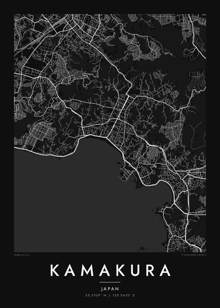
The straight processional avenue runs from the Hachimangū shrine to the sea, a single decisive line through the centre that gives the whole map its orientation.
Qeeqabak kaartah poster · Japan
35.3109° N / 139.5470° E
A former shogun's capital enclosed by wooded hills on three sides, opening south onto the curve of Sagami Bay.



Inki magaala, konoy gaba
Qande inkih tibbixeeh derre baguley table. Kulli qande missoowa caagid—daabbisimta, dirbaabu-le kaadu HD fayla akah.
 Cagalah pixels · 24 × 36″ daabbi fayla
Maxxaacah qeeqa
Tama usuk cagalah daabbi faylak 100% qambaala. Kulli poster — daabbisimta, dirbaabu-le kaadu download geytimta — ni-server-ittal 300 DPI-l ederimta, 7,200 × 10,800 pixels fanah, tokkel iyyi ellee catoy 24 × 36″ daabbi baxsi bahisak raaqu.
Gidarih


Kaarta
Kamakura was the seat of Japan's first shogunate from the late twelfth century, and it was chosen partly for its shape. Hills close in on the north, east and west, while the south opens onto the sea, a natural fortress reached through narrow cuttings in the ridges. On a map that bowl is still easy to read: dense streets in the lowland, green folds all around.
At the centre runs Wakamiya-ōji, a straight avenue laid out from Tsurugaoka Hachimangū shrine down to the beach at Yuigahama. It is the clearest axis in the city and the spine around which everything else falls into place. To the west, in the Hase district, the Great Buddha of Kōtoku-in sits in the open air, a bronze figure cast in the thirteenth century.
A Kamakura map poster holds a remarkable amount in one frame: the ceremonial avenue, the beach curving toward the headland, temple grounds tucked into valleys and lanes that wind into the hills. It is a favourite with people who have visited from Tokyo or Yokohama, and a meaningful map for anyone interested in Japanese history.
The straight processional avenue runs from the Hachimangū shrine to the sea, a single decisive line through the centre that gives the whole map its orientation.
The beach forms a smooth arc along Sagami Bay at the southern edge of the city, a clean boundary between dense streets and open water.
Temples and shrines sit in narrow valleys cut into the surrounding hills, visible on the map as small pockets of paths and buildings reached by winding lanes.
Kok tanim ab
Ayro, migaq hinnay kok tan xagar osis; gaba, ballaqa hinnay xiqa soorris.
Free preview qansarissi kee watermark-le. Daabbisimtaan kee HD fayla 300 DPI-l, 7,200 × 10,800 px fanah, watermark maleh ederimta.
Macah Kamakura
Kamakura is often a day of quiet memories: the walk to the Great Buddha, the beach at sunset, a temple garden in the hills. A map captures the whole day in one image, and the city's shape makes it recognisable at a glance.
Personalise the title, subtitle and coordinates line, for example with the date of a trip or a honeymoon, and choose one of five styles: Classic black & white, Noir, Paper, Blueprint or Sand. Paper suits the historic streets especially well.
Kamakura poster orme| Maxxaacah ballaqa | Qeeqa | Faylal |
|---|---|---|
| 30 × 40 cm (11.8 × 15.7″) | 3,543 × 4,724 px | PNG · PDF |
| 29.7 × 42 cm (A3, 11.7 × 16.5″) | 3,508 × 4,961 px | PNG · PDF |
| 42 × 59.4 cm (A2, 16.5 × 23.4″) | 4,961 × 7,016 px | PNG · PDF |
| 45.7 × 61 cm (18 × 24″) | 5,400 × 7,200 px | PNG · PDF |
| 50 × 70 cm (19.7 × 27.6″) | 5,906 × 8,268 px | PNG · PDF |
| 61 × 91.4 cm (24 × 36″) | 7,200 × 10,800 px | PNG · PDF |
Tabbaltah, limo-wayta xaqqa-le ablo 900 px ballaqa le, asta le, iskiriinih keh tan. HD faylal gexsoh inkih addal 8× fanah qeeqa le, poster ballaqa inkih addal meqeh maxxaacimta.
Baxxaqqa qari le qandiy dooriy, tohuk lakal Daabbisimtah Poster — kutuk kee, faxximek, dirbaabu — hinnay HD Digital Fayla dooru. Checkout inki wagitti geytima, kaadu ku-orme page keenih adissa akke waqdi caagoy kummite.
Usuk 200 gsm-le catam kutuk warqatal, lica katiy caagitte $39-ik hane ayta 30 × 40 cm-ik 24 × 36″ fanah, xaagu keenil warreeh.
Ee. Sarrah-le dirbaabu doori — bad, gudduc, oak-le hinnay bad-madabuy. Usuk finqisiimam ellee sange qarab-le kaadu qari umukku iyya keenih taagu. Dirbaabu-le poster $99-ik hane, xaagu keenil warreeh.
Shipping is free worldwide. Each poster is printed by the nearest of our print partners in 30+ countries and usually arrives in 3–7 business days. You can follow the status and tracking under My Orders. A few countries take 2–5 weeks, and where we don't ship yet, the site tells you before you pay.
Geytimeek 14 ayróy addal foto naah rubbaay, cisab-le daabbisiynah hinnay ku-lacay gacisnaah.
Ee. Tama page-l edito addal, migaaq, subtitle kee coordinates sarrah faxxem fanah badal, kaadu qande kee katiy doori. Daabbisimtah, dirbaabu-le kaadu digital orme inkih ku-design cagalah yekkelen.
$9 bacisak 300 DPI PNG kee daabbisimtah adissime PDF fayla lica katiy inkih, watermark maleh, ayyi meki daabbisimtah geeytitta. Cisab makkoysemty ana? Awqak, watermark-le free preview download-eh.
Xayyo
