Upland setting
The town occupies an open plateau high above sea level, so the map shows a clear, compact core surrounded by broad expanses of farmland and pasture.
Qeeqabak kaartah poster · Iran
37.6184° N / 48.5293° E
A high mountain town in Iran's northwest, set on an open plateau with the forested Talysh ranges falling toward the Caspian


Inki magaala, konoy gaba
Qande inkih tibbixeeh derre baguley table. Kulli qande missoowa caagid—daabbisimta, dirbaabu-le kaadu HD fayla akah.
 Cagalah pixels · 24 × 36″ daabbi fayla
Maxxaacah qeeqa
Tama usuk cagalah daabbi faylak 100% qambaala. Kulli poster — daabbisimta, dirbaabu-le kaadu download geytimta — ni-server-ittal 300 DPI-l ederimta, 7,200 × 10,800 pixels fanah, tokkel iyyi ellee catoy 24 × 36″ daabbi baxsi bahisak raaqu.
Gidarih


Kaarta
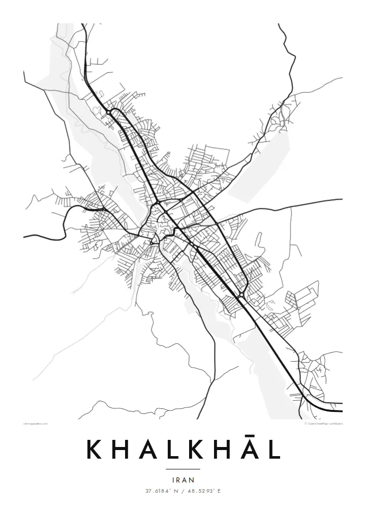
Khalkhāl sits at around 1,800 metres in the south of Ardabil Province, one of the higher towns in Iran. The map shows a compact settlement on open upland, its streets gathered around a dense central core, with fields and pasture spreading out in every direction until the ground begins to climb toward the surrounding ridges.
To the east rise the Talysh Mountains, which separate this plateau from the humid Caspian lowlands. The road from Khalkhāl to Asalem crosses them, climbing through meadows and then dropping through dense Hyrcanian forest to the coast, and it has become one of the best-known scenic drives in northern Iran. It leaves town as a thin, winding line.
Winters here are long and snowy, and the town has the solid, practical form of a place built for cold. A Khalkhāl map poster keeps that character: a dense core, a few firm main roads, and open upland reaching toward the mountains. It suits anyone who knows the sharpness of the air on this plateau.
The town occupies an open plateau high above sea level, so the map shows a clear, compact core surrounded by broad expanses of farmland and pasture.
The route east over the Talysh Mountains leaves town as a thin, twisting line, the beginning of a celebrated drive from alpine meadows down to Caspian forest.
The centre is a tight cluster of streets from which roads lead out toward surrounding villages and valleys, a clear, legible structure that holds up well in black and white.
Kok tanim ab
Ayro, migaq hinnay kok tan xagar osis; gaba, ballaqa hinnay xiqa soorris.
Free preview qansarissi kee watermark-le. Daabbisimtaan kee HD fayla 300 DPI-l, 7,200 × 10,800 px fanah, watermark maleh ederimta.
Macah Khalkhāl
For people from Khalkhāl who now live elsewhere, a map of the home town is a quiet way to keep it close. It also appeals to travellers who have driven the Asalem road and want something more considered than a photograph to remember the mountains by.
Choose Classic black & white for a crisp look or Noir for a darker, wintry mood, or try Paper, Blueprint or Sand. The title, subtitle and coordinates line are yours to edit. Download the HD files for $9 or order a printed poster with an optional wooden frame.
Khalkhāl poster orme| Maxxaacah ballaqa | Qeeqa | Faylal |
|---|---|---|
| 30 × 40 cm (11.8 × 15.7″) | 3,543 × 4,724 px | PNG · PDF |
| 29.7 × 42 cm (A3, 11.7 × 16.5″) | 3,508 × 4,961 px | PNG · PDF |
| 42 × 59.4 cm (A2, 16.5 × 23.4″) | 4,961 × 7,016 px | PNG · PDF |
| 45.7 × 61 cm (18 × 24″) | 5,400 × 7,200 px | PNG · PDF |
| 50 × 70 cm (19.7 × 27.6″) | 5,906 × 8,268 px | PNG · PDF |
| 61 × 91.4 cm (24 × 36″) | 7,200 × 10,800 px | PNG · PDF |
Tabbaltah, limo-wayta xaqqa-le ablo 900 px ballaqa le, asta le, iskiriinih keh tan. HD faylal gexsoh inkih addal 8× fanah qeeqa le, poster ballaqa inkih addal meqeh maxxaacimta.
Baxxaqqa qari le qandiy dooriy, tohuk lakal Daabbisimtah Poster — kutuk kee, faxximek, dirbaabu — hinnay HD Digital Fayla dooru. Checkout inki wagitti geytima, kaadu ku-orme page keenih adissa akke waqdi caagoy kummite.
Usuk 200 gsm-le catam kutuk warqatal, lica katiy caagitte {printFrom}-ik hane ayta 30 × 40 cm-ik 24 × 36″ fanah, xaagu keenil warreeh.
Ee. Sarrah-le dirbaabu doori — bad, gudduc, oak-le hinnay bad-madabuy. Usuk finqisiimam ellee sange qarab-le kaadu qari umukku iyya keenih taagu. Dirbaabu-le poster {framedFrom}-ik hane, xaagu keenil warreeh.
Shipping is free worldwide. Each poster is printed by the nearest of our print partners in 30+ countries and usually arrives in 3–7 business days. You can follow the status and tracking under My Orders. A few countries take 2–5 weeks, and where we don't ship yet, the site tells you before you pay.
Geytimeek 14 ayróy addal foto naah rubbaay, cisab-le daabbisiynah hinnay ku-lacay gacisnaah.
Ee. Tama page-l edito addal, migaaq, subtitle kee coordinates sarrah faxxem fanah badal, kaadu qande kee katiy doori. Daabbisimtah, dirbaabu-le kaadu digital orme inkih ku-design cagalah yekkelen.
$9 bacisak 300 DPI PNG kee daabbisimtah adissime PDF fayla lica katiy inkih, watermark maleh, ayyi meki daabbisimtah geeytitta. Cisab makkoysemty ana? Awqak, watermark-le free preview download-eh.
Xayyo
