Tidal creeks
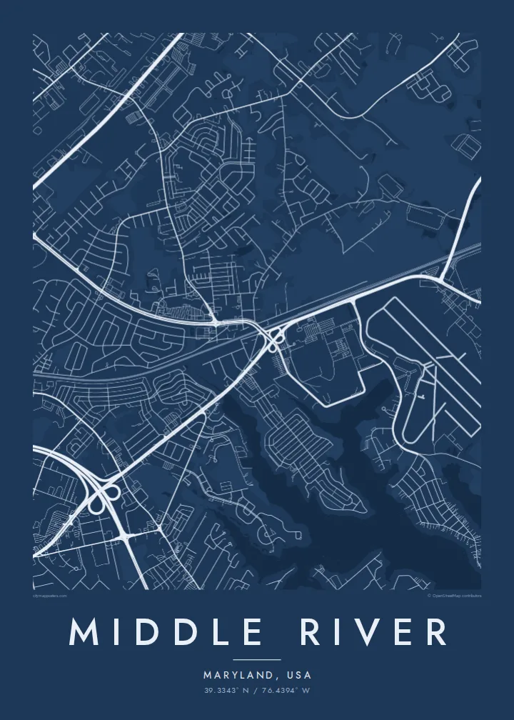
Middle River and nearby creeks cut deep into the land, creating a jagged coastline of coves and points that gives the poster its character.
Qeeqabak kaartah poster · United States
39.3343° N / 76.4394° W
A waterfront community east of Baltimore, where creeks and peninsulas reach into the Chesapeake beside a historic airfield.



Inki magaala, konoy gaba
Qande inkih tibbixeeh derre baguley table. Kulli qande missoowa caagid—daabbisimta, dirbaabu-le kaadu HD fayla akah.
 Cagalah pixels · 24 × 36″ daabbi fayla
Maxxaacah qeeqa
Tama usuk cagalah daabbi faylak 100% qambaala. Kulli poster — daabbisimta, dirbaabu-le kaadu download geytimta — ni-server-ittal 300 DPI-l ederimta, 7,200 × 10,800 pixels fanah, tokkel iyyi ellee catoy 24 × 36″ daabbi baxsi bahisak raaqu.
Gidarih


Kaarta
Middle River lies in eastern Baltimore County, on a stretch of Chesapeake Bay shoreline cut by tidal rivers and creeks. On a map the land breaks into fingers and peninsulas separated by water. Residential streets follow the shorelines, and marinas are tucked into sheltered inlets all along the way.
The community grew around the Glenn L. Martin Company, which built a large aircraft plant here in the late 1920s and produced aircraft through the Second World War. Its airfield is now Martin State Airport. The runways and industrial buildings remain among the most distinctive features of the area.
A Middle River map poster is defined by the interplay of land and water. The tidal river and its creeks give the composition deep, irregular inlets, while the straight runways and factory blocks add strong geometry. The map feels both coastal and industrial, unlike any inland suburb.
Middle River and nearby creeks cut deep into the land, creating a jagged coastline of coves and points that gives the poster its character.
The runways of the former Martin aircraft plant form sharp straight lines beside the water, a clear reminder of the area's aviation history.
Residential roads follow each of the peninsulas to its tip, ending in cul-de-sacs, private piers and small marinas along the shoreline.
Kok tanim ab
Ayro, migaq hinnay kok tan xagar osis; gaba, ballaqa hinnay xiqa soorris.
Free preview qansarissi kee watermark-le. Daabbisimtaan kee HD fayla 300 DPI-l, 7,200 × 10,800 px fanah, watermark maleh ederimta.
Macah Middle River
Middle River is a place of boats, waterfront homes and families with generations of ties to the plant and the water. A map of its creeks is a natural choice for a waterside house or a gift for someone who grew up there.
Add a title and subtitle of your own, mark a date, and adjust the coordinates. Choose Classic black & white, Noir, Paper, Blueprint or Sand. Blueprint suits the aviation history, while Paper gives the shoreline a softer feel.
Middle River poster orme| Maxxaacah ballaqa | Qeeqa | Faylal |
|---|---|---|
| 30 × 40 cm11.8 × 15.7″ | 3,543 × 4,724 px | PNG · PDF |
| 29.7 × 42 cm (A3)11.7 × 16.5″ | 3,508 × 4,961 px | PNG · PDF |
| 42 × 59.4 cm (A2)16.5 × 23.4″ | 4,961 × 7,016 px | PNG · PDF |
| 45.7 × 61 cm18 × 24″ | 5,400 × 7,200 px | PNG · PDF |
| 50 × 70 cm19.7 × 27.6″ | 5,906 × 8,268 px | PNG · PDF |
| 61 × 91.4 cm24 × 36″ | 7,200 × 10,800 px | PNG · PDF |
Tabbaltah, limo-wayta xaqqa-le ablo 900 px ballaqa le, asta le, iskiriinih keh tan. HD faylal gexsoh inkih addal 8× fanah qeeqa le, poster ballaqa inkih addal meqeh maxxaacimta.
Baxxaqqa qari le qandiy dooriy, tohuk lakal Daabbisimtah Poster — kutuk kee, faxximek, dirbaabu — hinnay HD Digital Fayla dooru. Checkout inki wagitti geytima, kaadu ku-orme page keenih adissa akke waqdi caagoy kummite.
Usuk 200 gsm-le catam kutuk warqatal, lica katiy caagitte $39-ik hane ayta 30 × 40 cm-ik 24 × 36″ fanah, xaagu keenil warreeh.
Ee. Sarrah-le dirbaabu doori — bad, gudduc, oak-le hinnay bad-madabuy. Usuk finqisiimam ellee sange qarab-le kaadu qari umukku iyya keenih taagu. Dirbaabu-le poster $99-ik hane, xaagu keenil warreeh.
Dirsa 60+ baaxoh bilsa. Poster kasa 30+ baaxoh nel print kaadu yan kee dirgeh kaxxa kee tanah printa, kee 3–7 xaqu ayyaamah yaaxigeeh. Xaaloo kee tracking "Ac Order" gexsitam. Kaadu baaxo 2–5 isbuuc yaaxigeeh, nanu dirsi yanin baaxoh sajiitah site ku kalah tekkeh.
Geytimeek 14 ayróy addal foto naah rubbaay, cisab-le daabbisiynah hinnay ku-lacay gacisnaah.
Ee. Tama page-l edito addal, migaaq, subtitle kee coordinates sarrah faxxem fanah badal, kaadu qande kee katiy doori. Daabbisimtah, dirbaabu-le kaadu digital orme inkih ku-design cagalah yekkelen.
$9 bacisak 300 DPI PNG kee daabbisimtah adissime PDF fayla lica katiy inkih, watermark maleh, ayyi meki daabbisimtah geeytitta. Cisab makkoysemty ana? Awqak, watermark-le free preview download-eh.
Xayyo
