The sheltered bay
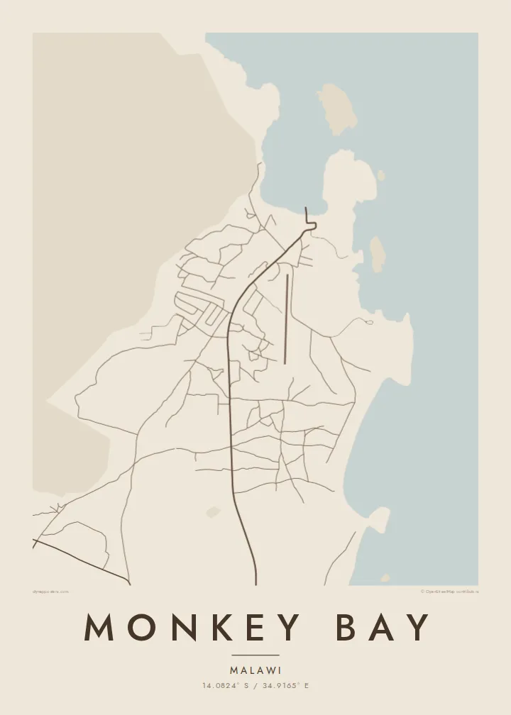
The town wraps around a curved inlet of Lake Malawi, protected from the open lake. This bay shape gives the poster its main outline and a strong, recognisable composition.
Qeeqabak kaartah poster · Malawi
14.0824° S / 34.9165° E
A lakeside town on the southern shore of Lake Malawi, beside a sheltered bay and the peninsula leading to Cape Maclear


Inki magaala, konoy gaba
Qande inkih tibbixeeh derre baguley table. Kulli qande missoowa caagid—daabbisimta, dirbaabu-le kaadu HD fayla akah.
 Cagalah pixels · 24 × 36″ daabbi fayla
Maxxaacah qeeqa
Tama usuk cagalah daabbi faylak 100% qambaala. Kulli poster — daabbisimta, dirbaabu-le kaadu download geytimta — ni-server-ittal 300 DPI-l ederimta, 7,200 × 10,800 pixels fanah, tokkel iyyi ellee catoy 24 × 36″ daabbi baxsi bahisak raaqu.
Gidarih


Kaarta
Monkey Bay lies at the southern end of Lake Malawi, on the peninsula that reaches out toward Cape Maclear. The town curves around a sheltered bay, with hills rising behind the shoreline and the open water of the lake stretching north. On a map the coastline dominates, and the settlement appears as a band of streets and houses following the shape of the bay.
The town is a working lake port. It is the home base of the MV Ilala, the long-serving passenger ferry that travels up the lake, and it hosts a base of the Malawian navy's lake fleet. A short distance away, Cape Maclear lies within Lake Malawi National Park, a UNESCO World Heritage Site known for its many species of cichlid fish.
A Monkey Bay map poster is really a portrait of shoreline. The curve of the bay, the rocky headlands and the hills behind the town give the map a strong natural outline, while the streets and harbour add a small, human scale. In black and white the lake becomes a wide, calm space against which the town is clearly drawn.
The town wraps around a curved inlet of Lake Malawi, protected from the open lake. This bay shape gives the poster its main outline and a strong, recognisable composition.
Monkey Bay's port, home of the MV Ilala, appears as a small cluster of piers and buildings along the shore, marking the point where the town meets the water.
Beyond the town, the land stretches out into a hilly peninsula toward Cape Maclear and the national park, with a rugged coastline of bays and headlands.
Kok tanim ab
Ayro, migaq hinnay kok tan xagar osis; gaba, ballaqa hinnay xiqa soorris.
Free preview qansarissi kee watermark-le. Daabbisimtaan kee HD fayla 300 DPI-l, 7,200 × 10,800 px fanah, watermark maleh ederimta.
Macah Monkey Bay
Monkey Bay is a starting point for journeys on Lake Malawi and to Cape Maclear. The map suits travellers who crossed the lake on the Ilala, volunteers who lived nearby, and anyone who grew up on this stretch of shore.
Personalise the title, subtitle and coordinates to mark a journey or a year, and choose Classic black & white, Noir, Paper, Blueprint or Sand. Files are $9 for six print sizes, or a printed poster ships from partners in 30+ countries.
Monkey Bay poster orme| Maxxaacah ballaqa | Qeeqa | Faylal |
|---|---|---|
| 30 × 40 cm (11.8 × 15.7″) | 3,543 × 4,724 px | PNG · PDF |
| 29.7 × 42 cm (A3, 11.7 × 16.5″) | 3,508 × 4,961 px | PNG · PDF |
| 42 × 59.4 cm (A2, 16.5 × 23.4″) | 4,961 × 7,016 px | PNG · PDF |
| 45.7 × 61 cm (18 × 24″) | 5,400 × 7,200 px | PNG · PDF |
| 50 × 70 cm (19.7 × 27.6″) | 5,906 × 8,268 px | PNG · PDF |
| 61 × 91.4 cm (24 × 36″) | 7,200 × 10,800 px | PNG · PDF |
Tabbaltah, limo-wayta xaqqa-le ablo 900 px ballaqa le, asta le, iskiriinih keh tan. HD faylal gexsoh inkih addal 8× fanah qeeqa le, poster ballaqa inkih addal meqeh maxxaacimta.
Baxxaqqa qari le qandiy dooriy, tohuk lakal Daabbisimtah Poster — kutuk kee, faxximek, dirbaabu — hinnay HD Digital Fayla dooru. Checkout inki wagitti geytima, kaadu ku-orme page keenih adissa akke waqdi caagoy kummite.
Usuk 200 gsm-le catam kutuk warqatal, lica katiy caagitte {printFrom}-ik hane ayta 30 × 40 cm-ik 24 × 36″ fanah, xaagu keenil warreeh.
Ee. Sarrah-le dirbaabu doori — bad, gudduc, oak-le hinnay bad-madabuy. Usuk finqisiimam ellee sange qarab-le kaadu qari umukku iyya keenih taagu. Dirbaabu-le poster {framedFrom}-ik hane, xaagu keenil warreeh.
Xaagu addunyal inkih cisab-le. Kulli poster 30+ ummattak ni-daabbi-mara mananih xayyoysa kaadu 3–7 caagu-ayróh fanah geeytima. Ku-orme kee xaagu tarikiy My Orders addal ablitta.
Geytimeek 14 ayróy addal foto naah rubbaay, cisab-le daabbisiynah hinnay ku-lacay gacisnaah.
Ee. Tama page-l edito addal, migaaq, subtitle kee coordinates sarrah faxxem fanah badal, kaadu qande kee katiy doori. Daabbisimtah, dirbaabu-le kaadu digital orme inkih ku-design cagalah yekkelen.
$9 bacisak 300 DPI PNG kee daabbisimtah adissime PDF fayla lica katiy inkih, watermark maleh, ayyi meki daabbisimtah geeytitta. Cisab makkoysemty ana? Awqak, watermark-le free preview download-eh.
Xayyo
