The Kaveri
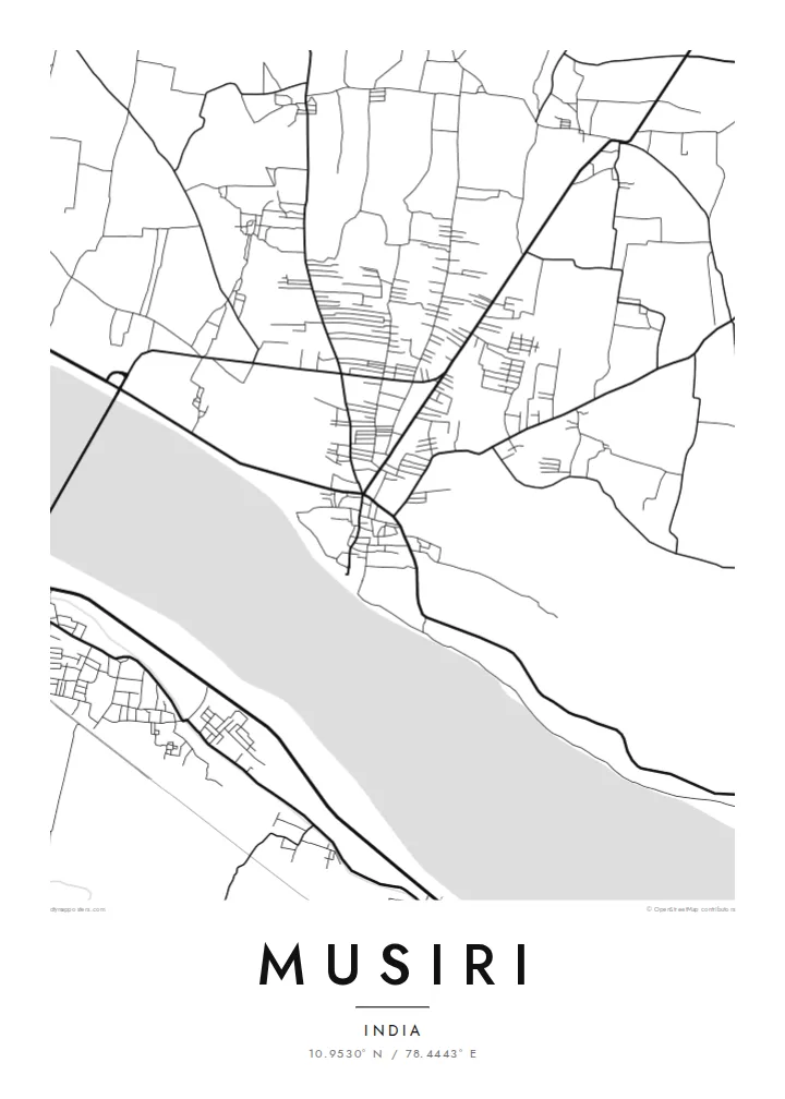
The river runs broad and low past the town, and its channel shifts between water and sand. It forms the southern border of the map and its strongest shape.
Qeeqabak kaartah poster · India
10.9530° N / 78.4443° E
A riverside town on the Kaveri's northern bank, its streets running alongside a wide, braided channel of water and sand.


Inki magaala, konoy gaba
Qande inkih tibbixeeh derre baguley table. Kulli qande missoowa caagid—daabbisimta, dirbaabu-le kaadu HD fayla akah.
 Cagalah pixels · 24 × 36″ daabbi fayla
Maxxaacah qeeqa
Tama usuk cagalah daabbi faylak 100% qambaala. Kulli poster — daabbisimta, dirbaabu-le kaadu download geytimta — ni-server-ittal 300 DPI-l ederimta, 7,200 × 10,800 pixels fanah, tokkel iyyi ellee catoy 24 × 36″ daabbi baxsi bahisak raaqu.
Gidarih


Kaarta
Musiri is in Tiruchirappalli district, Tamil Nadu, on the northern bank of the Kaveri river upstream from Tiruchirappalli city. The river is the dominant feature of any map of the town. It is a broad band, sometimes full and sometimes braided with sandbars, and it runs roughly east to west along the southern edge of the settlement.
The town itself follows the river, with the main streets roughly parallel to the bank and smaller lanes branching north into farmland. The Kaveri delta and its upstream plains are among the most intensively farmed land in South India, so the map outside the built-up area is largely a pattern of fields, irrigation channels and village roads.
A Musiri map poster suits anyone who knows the town from daily life rather than a guidebook. The composition is simple and strong: a long river, a town strung along its shore, and a quiet farming landscape to the north. In black and white, the river's width and texture give the design its weight.
The river runs broad and low past the town, and its channel shifts between water and sand. It forms the southern border of the map and its strongest shape.
The main roads run parallel to the riverbank, so the town is long and narrow rather than round. That is typical of settlements that grew along the Kaveri.
North of the town, the land becomes a pattern of fields and small channels. Its fine, even texture contrasts with the denser streets near the river.
Kok tanim ab
Ayro, migaq hinnay kok tan xagar osis; gaba, ballaqa hinnay xiqa soorris.
Free preview qansarissi kee watermark-le. Daabbisimtaan kee HD fayla 300 DPI-l, 7,200 × 10,800 px fanah, watermark maleh ederimta.
Macah Musiri
For families from Musiri and the surrounding villages, the Kaveri and the streets beside it are a firm point of reference. A map of the town is a way to keep that riverbank close from a flat in Chennai, Bengaluru or overseas.
The title, subtitle and coordinates line can carry a family name, a date or a short dedication. The map comes in five styles: Classic black and white, Noir, Paper, Blueprint and Sand.
Musiri poster orme| Maxxaacah ballaqa | Qeeqa | Faylal |
|---|---|---|
| 30 × 40 cm11.8 × 15.7″ | 3,543 × 4,724 px | PNG · PDF |
| 29.7 × 42 cm (A3)11.7 × 16.5″ | 3,508 × 4,961 px | PNG · PDF |
| 42 × 59.4 cm (A2)16.5 × 23.4″ | 4,961 × 7,016 px | PNG · PDF |
| 45.7 × 61 cm18 × 24″ | 5,400 × 7,200 px | PNG · PDF |
| 50 × 70 cm19.7 × 27.6″ | 5,906 × 8,268 px | PNG · PDF |
| 61 × 91.4 cm24 × 36″ | 7,200 × 10,800 px | PNG · PDF |
Tabbaltah, limo-wayta xaqqa-le ablo 900 px ballaqa le, asta le, iskiriinih keh tan. HD faylal gexsoh inkih addal 8× fanah qeeqa le, poster ballaqa inkih addal meqeh maxxaacimta.
Baxxaqqa qari le qandiy dooriy, tohuk lakal Daabbisimtah Poster — kutuk kee, faxximek, dirbaabu — hinnay HD Digital Fayla dooru. Checkout inki wagitti geytima, kaadu ku-orme page keenih adissa akke waqdi caagoy kummite.
Usuk 200 gsm-le catam kutuk warqatal, lica katiy caagitte $39-ik hane ayta 30 × 40 cm-ik 24 × 36″ fanah, xaagu keenil warreeh.
Ee. Sarrah-le dirbaabu doori — bad, gudduc, oak-le hinnay bad-madabuy. Usuk finqisiimam ellee sange qarab-le kaadu qari umukku iyya keenih taagu. Dirbaabu-le poster $99-ik hane, xaagu keenil warreeh.
Dirsa 60+ baaxoh bilsa. Poster kasa 30+ baaxoh nel print kaadu yan kee dirgeh kaxxa kee tanah printa, kee 3–7 xaqu ayyaamah yaaxigeeh. Xaaloo kee tracking "Ac Order" gexsitam. Kaadu baaxo 2–5 isbuuc yaaxigeeh, nanu dirsi yanin baaxoh sajiitah site ku kalah tekkeh.
Geytimeek 14 ayróy addal foto naah rubbaay, cisab-le daabbisiynah hinnay ku-lacay gacisnaah.
Ee. Tama page-l edito addal, migaaq, subtitle kee coordinates sarrah faxxem fanah badal, kaadu qande kee katiy doori. Daabbisimtah, dirbaabu-le kaadu digital orme inkih ku-design cagalah yekkelen.
$9 bacisak 300 DPI PNG kee daabbisimtah adissime PDF fayla lica katiy inkih, watermark maleh, ayyi meki daabbisimtah geeytitta. Cisab makkoysemty ana? Awqak, watermark-le free preview download-eh.
