Railway through town
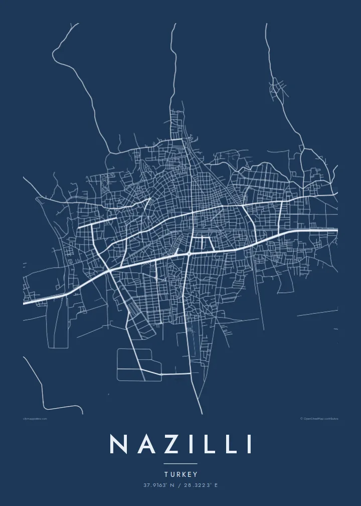
The İzmir–Denizli line runs straight through Nazilli, and the town grew along it. On the map the tracks form a clean spine that divides the northern and southern districts.
Qeeqabak kaartah poster · Türkiye
37.9163° N / 28.3223° E
A long valley town laid along the railway and the Büyük Menderes plain, with mountain slopes rising to its north



Inki magaala, konoy gaba
Qande inkih tibbixeeh derre baguley table. Kulli qande missoowa caagid—daabbisimta, dirbaabu-le kaadu HD fayla akah.
 Cagalah pixels · 24 × 36″ daabbi fayla
Maxxaacah qeeqa
Tama usuk cagalah daabbi faylak 100% qambaala. Kulli poster — daabbisimta, dirbaabu-le kaadu download geytimta — ni-server-ittal 300 DPI-l ederimta, 7,200 × 10,800 pixels fanah, tokkel iyyi ellee catoy 24 × 36″ daabbi baxsi bahisak raaqu.
Gidarih


Kaarta
Nazilli lies in the valley of the Büyük Menderes, the river whose winding course gave the English language the word meander. The town stretches east to west across the valley floor, following the main road and the railway between İzmir and Denizli. North of the centre, the ground climbs towards the Aydın Mountains, and the streets thin out as the slope rises.
The town has an important place in Turkish industrial history. In 1937 one of the first state textile factories of the Republic opened here, built to process the cotton grown in the surrounding plain. The valley is also known for its figs, and orchards and fields still surround the town on the map.
A Nazilli map poster captures the long, linear form of a valley town: the railway as a firm line through the middle, the grid of streets on either side, and the farmland of the Menderes plain opening to the south. It is an orderly, horizontal composition that suits a wide frame.
The İzmir–Denizli line runs straight through Nazilli, and the town grew along it. On the map the tracks form a clean spine that divides the northern and southern districts.
To the south the valley floor opens into flat agricultural land that reaches towards the Büyük Menderes. Its field boundaries give the lower part of the poster a light, open texture.
On the northern edge, streets begin to curve with the terrain as the ground rises towards the mountains. The shift from grid to winding roads is visible in the street pattern.
Kok tanim ab
Ayro, migaq hinnay kok tan xagar osis; gaba, ballaqa hinnay xiqa soorris.
Free preview qansarissi kee watermark-le. Daabbisimtaan kee HD fayla 300 DPI-l, 7,200 × 10,800 px fanah, watermark maleh ederimta.
Macah Nazilli
For anyone from the Aydın region, Nazilli is a familiar valley town of markets, trains and fig orchards. A map of it makes a grounded gift for someone who studied, worked or grew up here, or who still visits family in the valley.
The title, subtitle and coordinates line can all be personalised, so you might add a street name, a family surname or a date. Choose Classic black and white, Noir, Paper, Blueprint or Sand to suit the room where it will hang.
Nazilli poster orme| Maxxaacah ballaqa | Qeeqa | Faylal |
|---|---|---|
| 30 × 40 cm (11.8 × 15.7″) | 3,543 × 4,724 px | PNG · PDF |
| 29.7 × 42 cm (A3, 11.7 × 16.5″) | 3,508 × 4,961 px | PNG · PDF |
| 42 × 59.4 cm (A2, 16.5 × 23.4″) | 4,961 × 7,016 px | PNG · PDF |
| 45.7 × 61 cm (18 × 24″) | 5,400 × 7,200 px | PNG · PDF |
| 50 × 70 cm (19.7 × 27.6″) | 5,906 × 8,268 px | PNG · PDF |
| 61 × 91.4 cm (24 × 36″) | 7,200 × 10,800 px | PNG · PDF |
Tabbaltah, limo-wayta xaqqa-le ablo 900 px ballaqa le, asta le, iskiriinih keh tan. HD faylal gexsoh inkih addal 8× fanah qeeqa le, poster ballaqa inkih addal meqeh maxxaacimta.
Baxxaqqa qari le qandiy dooriy, tohuk lakal Daabbisimtah Poster — kutuk kee, faxximek, dirbaabu — hinnay HD Digital Fayla dooru. Checkout inki wagitti geytima, kaadu ku-orme page keenih adissa akke waqdi caagoy kummite.
Usuk 200 gsm-le catam kutuk warqatal, lica katiy caagitte {printFrom}-ik hane ayta 30 × 40 cm-ik 24 × 36″ fanah, xaagu keenil warreeh.
Ee. Sarrah-le dirbaabu doori — bad, gudduc, oak-le hinnay bad-madabuy. Usuk finqisiimam ellee sange qarab-le kaadu qari umukku iyya keenih taagu. Dirbaabu-le poster {framedFrom}-ik hane, xaagu keenil warreeh.
Xaagu addunyal inkih cisab-le. Kulli poster 30+ ummattak ni-daabbi-mara mananih xayyoysa kaadu 3–7 caagu-ayróh fanah geeytima. Ku-orme kee xaagu tarikiy My Orders addal ablitta.
Geytimeek 14 ayróy addal foto naah rubbaay, cisab-le daabbisiynah hinnay ku-lacay gacisnaah.
Ee. Tama page-l edito addal, migaaq, subtitle kee coordinates sarrah faxxem fanah badal, kaadu qande kee katiy doori. Daabbisimtah, dirbaabu-le kaadu digital orme inkih ku-design cagalah yekkelen.
$9 bacisak 300 DPI PNG kee daabbisimtah adissime PDF fayla lica katiy inkih, watermark maleh, ayyi meki daabbisimtah geeytitta. Cisab makkoysemty ana? Awqak, watermark-le free preview download-eh.
Xayyo
