Ohio River
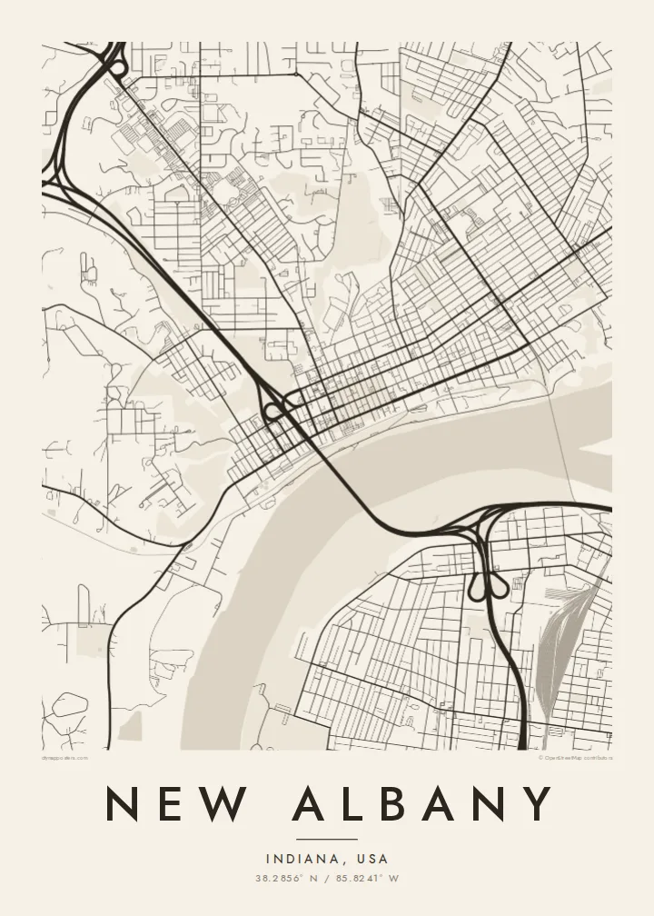
The wide river runs along the southern edge of the city, the largest shape on the poster and the reason New Albany was founded here.
Qeeqabak kaartah poster · United States
38.2856° N / 85.8241° W
A historic river city on the Ohio opposite Louisville, with a grid of old streets between the water and the knobs.




Inki magaala, konoy gaba
Qande inkih tibbixeeh derre baguley table. Kulli qande missoowa caagid—daabbisimta, dirbaabu-le kaadu HD fayla akah.
 Cagalah pixels · 24 × 36″ daabbi fayla
Maxxaacah qeeqa
Tama usuk cagalah daabbi faylak 100% qambaala. Kulli poster — daabbisimta, dirbaabu-le kaadu download geytimta — ni-server-ittal 300 DPI-l ederimta, 7,200 × 10,800 pixels fanah, tokkel iyyi ellee catoy 24 × 36″ daabbi baxsi bahisak raaqu.
Gidarih


Kaarta
New Albany sits on the north bank of the Ohio River in southern Indiana, directly across from Louisville. In the nineteenth century it was one of the largest cities in the state, and its shipyards built steamboats for the river trade. The wealth of that period is visible in Mansion Row, a historic district of large houses along one of the main streets.
On the map, the Ohio River is the dominant feature, a broad band along the southern edge. The old city grid runs parallel to the river, with straight streets and regular blocks. A bridge crosses the river to Kentucky, and a floodwall runs along the waterfront. To the west, the land rises steeply into the Knobs, a line of hills that limits the city's spread.
A New Albany map poster shows a river city in its classic form: water, grid, bridge and hills. The layout has changed little since the city's steamboat years, which makes the map a direct link to that history. For people from the Louisville area on either side of the river, it is a familiar and meaningful view.
The wide river runs along the southern edge of the city, the largest shape on the poster and the reason New Albany was founded here.
Straight streets and regular blocks run parallel to the river in the historic centre, a clear nineteenth-century layout that reads well at any size.
West of the city the ground climbs into steep hills, where streets become sparse and winding, framing the flat riverside grid below.
Kok tanim ab
Ayro, migaq hinnay kok tan xagar osis; gaba, ballaqa hinnay xiqa soorris.
Free preview qansarissi kee watermark-le. Daabbisimtaan kee HD fayla 300 DPI-l, 7,200 × 10,800 px fanah, watermark maleh ederimta.
Macah New Albany
New Albany suits people who love river cities, historic neighbourhoods and the Louisville area. A map of its grid and waterfront keeps that sense of place close, whether you live there or grew up there.
Personalise the title, add a subtitle such as a street or a year, and edit the coordinates. Choose from Classic black and white, Noir, Paper, Blueprint and Sand; Blueprint highlights the river strongly.
New Albany poster orme| Maxxaacah ballaqa | Qeeqa | Faylal |
|---|---|---|
| 30 × 40 cm11.8 × 15.7″ | 3,543 × 4,724 px | PNG · PDF |
| 29.7 × 42 cm (A3)11.7 × 16.5″ | 3,508 × 4,961 px | PNG · PDF |
| 42 × 59.4 cm (A2)16.5 × 23.4″ | 4,961 × 7,016 px | PNG · PDF |
| 45.7 × 61 cm18 × 24″ | 5,400 × 7,200 px | PNG · PDF |
| 50 × 70 cm19.7 × 27.6″ | 5,906 × 8,268 px | PNG · PDF |
| 61 × 91.4 cm24 × 36″ | 7,200 × 10,800 px | PNG · PDF |
Tabbaltah, limo-wayta xaqqa-le ablo 900 px ballaqa le, asta le, iskiriinih keh tan. HD faylal gexsoh inkih addal 8× fanah qeeqa le, poster ballaqa inkih addal meqeh maxxaacimta.
Baxxaqqa qari le qandiy dooriy, tohuk lakal Daabbisimtah Poster — kutuk kee, faxximek, dirbaabu — hinnay HD Digital Fayla dooru. Checkout inki wagitti geytima, kaadu ku-orme page keenih adissa akke waqdi caagoy kummite.
Usuk 200 gsm-le catam kutuk warqatal, lica katiy caagitte $39-ik hane ayta 30 × 40 cm-ik 24 × 36″ fanah, xaagu keenil warreeh.
Ee. Sarrah-le dirbaabu doori — bad, gudduc, oak-le hinnay bad-madabuy. Usuk finqisiimam ellee sange qarab-le kaadu qari umukku iyya keenih taagu. Dirbaabu-le poster $99-ik hane, xaagu keenil warreeh.
Dirsa 60+ baaxoh bilsa. Poster kasa 30+ baaxoh nel print kaadu yan kee dirgeh kaxxa kee tanah printa, kee 3–7 xaqu ayyaamah yaaxigeeh. Xaaloo kee tracking "Ac Order" gexsitam. Kaadu baaxo 2–5 isbuuc yaaxigeeh, nanu dirsi yanin baaxoh sajiitah site ku kalah tekkeh.
Geytimeek 14 ayróy addal foto naah rubbaay, cisab-le daabbisiynah hinnay ku-lacay gacisnaah.
Ee. Tama page-l edito addal, migaaq, subtitle kee coordinates sarrah faxxem fanah badal, kaadu qande kee katiy doori. Daabbisimtah, dirbaabu-le kaadu digital orme inkih ku-design cagalah yekkelen.
$9 bacisak 300 DPI PNG kee daabbisimtah adissime PDF fayla lica katiy inkih, watermark maleh, ayyi meki daabbisimtah geeytitta. Cisab makkoysemty ana? Awqak, watermark-le free preview download-eh.
