Nobbys breakwater
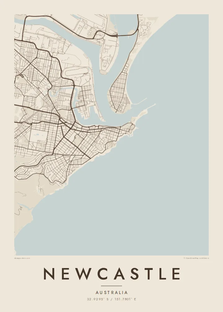
The breakwater runs from the city out to Nobbys Head at the harbour mouth. On the poster it is a slim, straight line that points into the empty ocean.
Qeeqabak kaartah poster · Australia
32.9295° S / 151.7801° E
A harbour city at the mouth of the Hunter River, with ocean beaches, headlands and a long breakwater pointing to sea


Inki magaala, konoy gaba
Qande inkih tibbixeeh derre baguley table. Kulli qande missoowa caagid—daabbisimta, dirbaabu-le kaadu HD fayla akah.
 Cagalah pixels · 24 × 36″ daabbi fayla
Maxxaacah qeeqa
Tama usuk cagalah daabbi faylak 100% qambaala. Kulli poster — daabbisimta, dirbaabu-le kaadu download geytimta — ni-server-ittal 300 DPI-l ederimta, 7,200 × 10,800 pixels fanah, tokkel iyyi ellee catoy 24 × 36″ daabbi baxsi bahisak raaqu.
Gidarih


Kaarta
Newcastle sits where the Hunter River meets the Pacific on the coast of New South Wales, about two hours north of Sydney. The city centre occupies a narrow tongue of land between the harbour and the ocean, its grid ending abruptly at the water on both sides, and the harbour entrance is guarded by the breakwater leading out to Nobbys Head and its lighthouse.
The port is one of the largest coal export harbours in the world, and its wharves, rail sidings and stockpiles spread across Kooragang Island and the riverbanks. Across the harbour, the Stockton peninsula runs north as a thin strip of sand. South of the centre, suburbs line up along a coast of surf beaches and rocky headlands toward Merewether.
At the foot of King Edward Park, the Bogey Hole, an ocean bath cut into the rock by convicts in the early nineteenth century, still fills with the tide. A Newcastle map poster brings these edges together: river, harbour, industry and surf, drawn as a single continuous coastline around a compact city grid.
The breakwater runs from the city out to Nobbys Head at the harbour mouth. On the poster it is a slim, straight line that points into the empty ocean.
The harbour and river channels wrap around Kooragang Island and the port facilities. Their branching shapes form the most complex part of the map, full of wharves and inlets.
South of the centre, beaches and headlands alternate along the Pacific shore. The coastline gives the print a clean edge and a gentle rhythm of curves and points.
Kok tanim ab
Ayro, migaq hinnay kok tan xagar osis; gaba, ballaqa hinnay xiqa soorris.
Free preview qansarissi kee watermark-le. Daabbisimtaan kee HD fayla 300 DPI-l, 7,200 × 10,800 px fanah, watermark maleh ederimta.
Macah Newcastle
Newcastle has a loyal crowd, from people who grew up surfing its beaches to those who came to study and never quite left. The map shows the working port and the coastline together, which is how locals know the city.
Set a custom title and subtitle, add the coordinates of your favourite break or your street, and choose from Classic black & white, Noir, Paper, Blueprint or Sand. Prints ship on matte paper, with an optional wooden frame.
Newcastle poster orme| Maxxaacah ballaqa | Qeeqa | Faylal |
|---|---|---|
| 30 × 40 cm (11.8 × 15.7″) | 3,543 × 4,724 px | PNG · PDF |
| 29.7 × 42 cm (A3, 11.7 × 16.5″) | 3,508 × 4,961 px | PNG · PDF |
| 42 × 59.4 cm (A2, 16.5 × 23.4″) | 4,961 × 7,016 px | PNG · PDF |
| 45.7 × 61 cm (18 × 24″) | 5,400 × 7,200 px | PNG · PDF |
| 50 × 70 cm (19.7 × 27.6″) | 5,906 × 8,268 px | PNG · PDF |
| 61 × 91.4 cm (24 × 36″) | 7,200 × 10,800 px | PNG · PDF |
Tabbaltah, limo-wayta xaqqa-le ablo 900 px ballaqa le, asta le, iskiriinih keh tan. HD faylal gexsoh inkih addal 8× fanah qeeqa le, poster ballaqa inkih addal meqeh maxxaacimta.
Baxxaqqa qari le qandiy dooriy, tohuk lakal Daabbisimtah Poster — kutuk kee, faxximek, dirbaabu — hinnay HD Digital Fayla dooru. Checkout inki wagitti geytima, kaadu ku-orme page keenih adissa akke waqdi caagoy kummite.
Usuk 200 gsm-le catam kutuk warqatal, lica katiy caagitte $39-ik hane ayta 30 × 40 cm-ik 24 × 36″ fanah, xaagu keenil warreeh.
Ee. Sarrah-le dirbaabu doori — bad, gudduc, oak-le hinnay bad-madabuy. Usuk finqisiimam ellee sange qarab-le kaadu qari umukku iyya keenih taagu. Dirbaabu-le poster $99-ik hane, xaagu keenil warreeh.
Shipping is free worldwide. Each poster is printed by the nearest of our print partners in 30+ countries and usually arrives in 3–7 business days. You can follow the status and tracking under My Orders. A few countries take 2–5 weeks, and where we don't ship yet, the site tells you before you pay.
Geytimeek 14 ayróy addal foto naah rubbaay, cisab-le daabbisiynah hinnay ku-lacay gacisnaah.
Ee. Tama page-l edito addal, migaaq, subtitle kee coordinates sarrah faxxem fanah badal, kaadu qande kee katiy doori. Daabbisimtah, dirbaabu-le kaadu digital orme inkih ku-design cagalah yekkelen.
$9 bacisak 300 DPI PNG kee daabbisimtah adissime PDF fayla lica katiy inkih, watermark maleh, ayyi meki daabbisimtah geeytitta. Cisab makkoysemty ana? Awqak, watermark-le free preview download-eh.
Xayyo
