Stepped river terraces
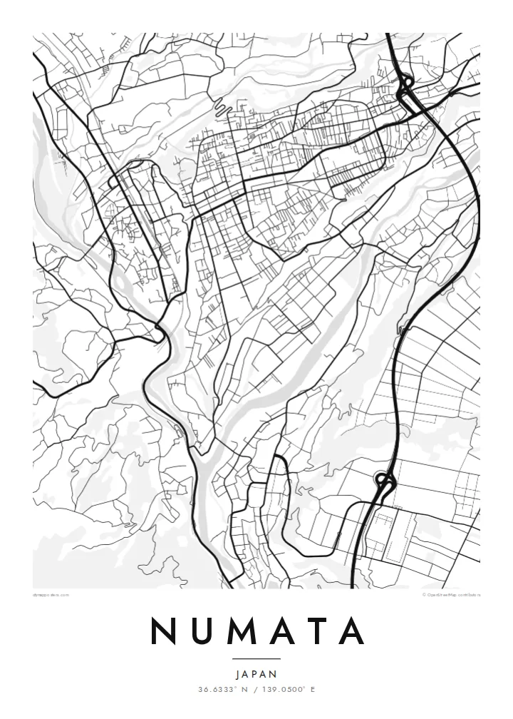
The centre sits on flat shelves cut by the Tone and Katashina rivers. On the map, the street grid stops sharply where the terraces fall toward the valleys.
Qeeqabak kaartah poster · Japan
36.6333° N / 139.0500° E
A town set on high river terraces above the Katashina and Tone rivers, with mountains closing in from every side


Inki magaala, konoy gaba
Qande inkih tibbixeeh derre baguley table. Kulli qande missoowa caagid—daabbisimta, dirbaabu-le kaadu HD fayla akah.
 Cagalah pixels · 24 × 36″ daabbi fayla
Maxxaacah qeeqa
Tama usuk cagalah daabbi faylak 100% qambaala. Kulli poster — daabbisimta, dirbaabu-le kaadu download geytimta — ni-server-ittal 300 DPI-l ederimta, 7,200 × 10,800 pixels fanah, tokkel iyyi ellee catoy 24 × 36″ daabbi baxsi bahisak raaqu.
Gidarih


Kaarta
Numata sits on a raised plateau in northern Gunma, and from above the reason is easy to see. The Tone and Katashina rivers have cut deep valleys around the town, leaving the centre on flat, stepped terraces. Streets spread across the top of this shelf, and the ground drops away at its edges toward the water.
These river terraces are among the best-known examples of the landform in Japan. They give the map a layered look, with the dense grid of the old castle town on the upper level and roads curving down the slopes to the river below. Beyond the valleys, forested mountains fill the rest of the frame.
Numata grew as a castle town under the Sanada clan, and the castle site is now a park at the edge of the terrace. The wider city reaches north into the mountains, where Fukiware Falls cuts through a rock gorge. A Numata map poster shows how closely the town follows the shape of its ground.
The centre sits on flat shelves cut by the Tone and Katashina rivers. On the map, the street grid stops sharply where the terraces fall toward the valleys.
The former Numata Castle site sits at the edge of the upper terrace, a green space looking out over the river valley and the older streets.
The Tone and Katashina meet near the town, and their valleys make two clear lines through the frame that the roads have to cross or follow.
Kok tanim ab
Ayro, migaq hinnay kok tan xagar osis; gaba, ballaqa hinnay xiqa soorris.
Free preview qansarissi kee watermark-le. Daabbisimtaan kee HD fayla 300 DPI-l, 7,200 × 10,800 px fanah, watermark maleh ederimta.
Macah Numata
Numata suits people who like a map with visible geology. The terraces and valleys turn a small town plan into something close to a relief study, and the pattern holds up in the quiet Paper or Sand styles as well as in Classic black and white.
You can change the title, add a subtitle such as a date or family name, and edit the coordinates line. The digital files cost $9 and cover six print sizes, or you can order a matte print, with a wooden frame if you like.
Numata poster orme| Maxxaacah ballaqa | Qeeqa | Faylal |
|---|---|---|
| 30 × 40 cm (11.8 × 15.7″) | 3,543 × 4,724 px | PNG · PDF |
| 29.7 × 42 cm (A3, 11.7 × 16.5″) | 3,508 × 4,961 px | PNG · PDF |
| 42 × 59.4 cm (A2, 16.5 × 23.4″) | 4,961 × 7,016 px | PNG · PDF |
| 45.7 × 61 cm (18 × 24″) | 5,400 × 7,200 px | PNG · PDF |
| 50 × 70 cm (19.7 × 27.6″) | 5,906 × 8,268 px | PNG · PDF |
| 61 × 91.4 cm (24 × 36″) | 7,200 × 10,800 px | PNG · PDF |
Tabbaltah, limo-wayta xaqqa-le ablo 900 px ballaqa le, asta le, iskiriinih keh tan. HD faylal gexsoh inkih addal 8× fanah qeeqa le, poster ballaqa inkih addal meqeh maxxaacimta.
Baxxaqqa qari le qandiy dooriy, tohuk lakal Daabbisimtah Poster — kutuk kee, faxximek, dirbaabu — hinnay HD Digital Fayla dooru. Checkout inki wagitti geytima, kaadu ku-orme page keenih adissa akke waqdi caagoy kummite.
Usuk 200 gsm-le catam kutuk warqatal, lica katiy caagitte {printFrom}-ik hane ayta 30 × 40 cm-ik 24 × 36″ fanah, xaagu keenil warreeh.
Ee. Sarrah-le dirbaabu doori — bad, gudduc, oak-le hinnay bad-madabuy. Usuk finqisiimam ellee sange qarab-le kaadu qari umukku iyya keenih taagu. Dirbaabu-le poster {framedFrom}-ik hane, xaagu keenil warreeh.
Xaagu addunyal inkih cisab-le. Kulli poster 30+ ummattak ni-daabbi-mara mananih xayyoysa kaadu 3–7 caagu-ayróh fanah geeytima. Ku-orme kee xaagu tarikiy My Orders addal ablitta.
Geytimeek 14 ayróy addal foto naah rubbaay, cisab-le daabbisiynah hinnay ku-lacay gacisnaah.
Ee. Tama page-l edito addal, migaaq, subtitle kee coordinates sarrah faxxem fanah badal, kaadu qande kee katiy doori. Daabbisimtah, dirbaabu-le kaadu digital orme inkih ku-design cagalah yekkelen.
$9 bacisak 300 DPI PNG kee daabbisimtah adissime PDF fayla lica katiy inkih, watermark maleh, ayyi meki daabbisimtah geeytitta. Cisab makkoysemty ana? Awqak, watermark-le free preview download-eh.
Xayyo
