Pearl Harbor lochs
A natural harbour whose branching lochs reach deep into the south coast. Its shape is one of the most distinctive features of the island's outline.
Qeeqabak kaartah poster · United States
21.4834° N / 157.9646° W
A Hawaiian island formed by two parallel mountain ranges, with a plateau between them and Honolulu along the south shore.


Inki magaala, konoy gaba
Qande inkih tibbixeeh derre baguley table. Kulli qande missoowa caagid—daabbisimta, dirbaabu-le kaadu HD fayla akah.
 Cagalah pixels · 24 × 36″ daabbi fayla
Maxxaacah qeeqa
Tama usuk cagalah daabbi faylak 100% qambaala. Kulli poster — daabbisimta, dirbaabu-le kaadu download geytimta — ni-server-ittal 300 DPI-l ederimta, 7,200 × 10,800 pixels fanah, tokkel iyyi ellee catoy 24 × 36″ daabbi baxsi bahisak raaqu.
Gidarih


Kaarta
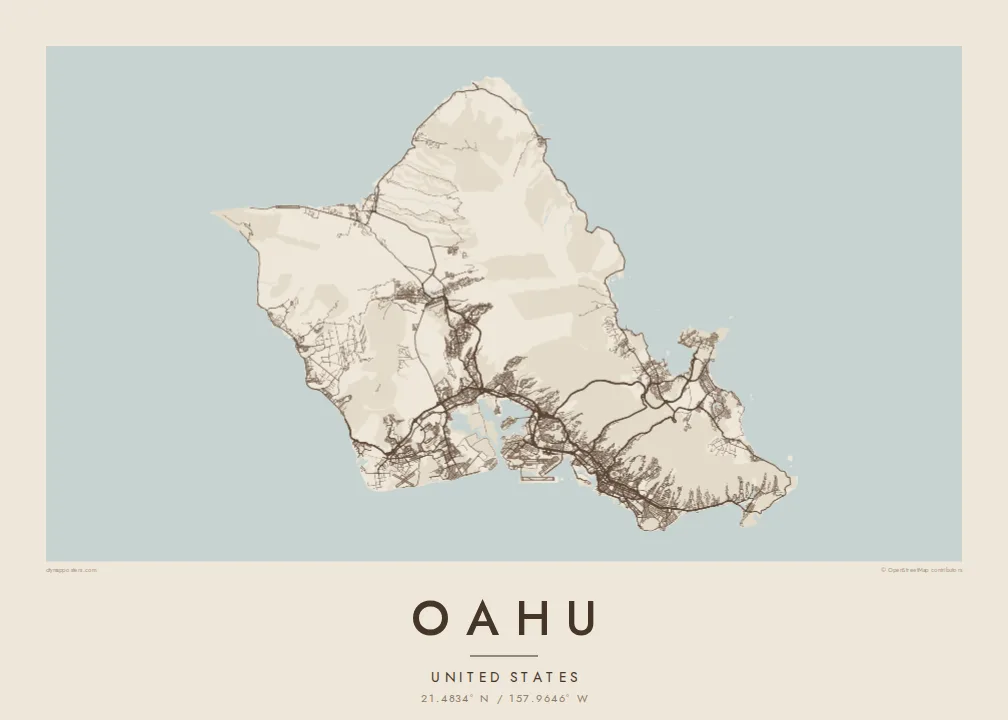
Oahu was built by two volcanoes, and their eroded remains still define its shape. The Waianae Range runs along the west side and the Koolau Range along the east, with a broad central plateau between them. The result is an island with a rough diamond outline, a busy southern coast and quieter northern and western shores.
Honolulu, Hawaii's capital, spreads along the south shore. Its streets run between the mountains and the sea, and Waikiki's hotels line the beach in the southeast. Beyond Waikiki, Diamond Head's crater forms a clean ring at the edge of the city. To the west, Pearl Harbor's branching lochs cut deeply into the land, a shape recognisable from above.
An Oahu map poster shows the contrast between the dense southern city and the rest of the island. The North Shore is known worldwide for its winter surf. The windward coast, facing east, runs beneath the steep, fluted cliffs of the Koolau. The H-1 freeway and other highways trace the island's main corridors across the plateau and along the coast.
A natural harbour whose branching lochs reach deep into the south coast. Its shape is one of the most distinctive features of the island's outline.
The volcanic crater at the eastern edge of Waikiki forms a near-perfect ring on the map, beside the dense grid of the city.
The Waianae and Koolau mountains run parallel along the west and east. The roads avoid their ridges and follow the valleys and coast instead.
Kok tanim ab
Ayro, migaq hinnay kok tan xagar osis; gaba, ballaqa hinnay xiqa soorris.
Free preview qansarissi kee watermark-le. Daabbisimtaan kee HD fayla 300 DPI-l, 7,200 × 10,800 px fanah, watermark maleh ederimta.
Macah Oahu
Oahu is home, a posting, a surf trip or the place where a family story began. A map of the whole island brings Honolulu, the North Shore and the windward coast onto one sheet and makes a strong, balanced print.
Personalise the title and subtitle, or set the coordinates line to a beach or a neighbourhood. Choose Classic black & white, Noir, Paper, Blueprint or Sand.
Oahu poster orme| Maxxaacah ballaqa | Qeeqa | Faylal |
|---|---|---|
| 30 × 40 cm (11.8 × 15.7″) | 3,543 × 4,724 px | PNG · PDF |
| 29.7 × 42 cm (A3, 11.7 × 16.5″) | 3,508 × 4,961 px | PNG · PDF |
| 42 × 59.4 cm (A2, 16.5 × 23.4″) | 4,961 × 7,016 px | PNG · PDF |
| 45.7 × 61 cm (18 × 24″) | 5,400 × 7,200 px | PNG · PDF |
| 50 × 70 cm (19.7 × 27.6″) | 5,906 × 8,268 px | PNG · PDF |
| 61 × 91.4 cm (24 × 36″) | 7,200 × 10,800 px | PNG · PDF |
Tabbaltah, limo-wayta xaqqa-le ablo 900 px ballaqa le, asta le, iskiriinih keh tan. HD faylal gexsoh inkih addal 8× fanah qeeqa le, poster ballaqa inkih addal meqeh maxxaacimta.
Baxxaqqa qari le qandiy dooriy, tohuk lakal Daabbisimtah Poster — kutuk kee, faxximek, dirbaabu — hinnay HD Digital Fayla dooru. Checkout inki wagitti geytima, kaadu ku-orme page keenih adissa akke waqdi caagoy kummite.
Usuk 200 gsm-le catam kutuk warqatal, lica katiy caagitte {printFrom}-ik hane ayta 30 × 40 cm-ik 24 × 36″ fanah, xaagu keenil warreeh.
Ee. Sarrah-le dirbaabu doori — bad, gudduc, oak-le hinnay bad-madabuy. Usuk finqisiimam ellee sange qarab-le kaadu qari umukku iyya keenih taagu. Dirbaabu-le poster {framedFrom}-ik hane, xaagu keenil warreeh.
Xaagu addunyal inkih cisab-le. Kulli poster 30+ ummattak ni-daabbi-mara mananih xayyoysa kaadu 3–7 caagu-ayróh fanah geeytima. Ku-orme kee xaagu tarikiy My Orders addal ablitta.
Geytimeek 14 ayróy addal foto naah rubbaay, cisab-le daabbisiynah hinnay ku-lacay gacisnaah.
Ee. Tama page-l edito addal, migaaq, subtitle kee coordinates sarrah faxxem fanah badal, kaadu qande kee katiy doori. Daabbisimtah, dirbaabu-le kaadu digital orme inkih ku-design cagalah yekkelen.
$9 bacisak 300 DPI PNG kee daabbisimtah adissime PDF fayla lica katiy inkih, watermark maleh, ayyi meki daabbisimtah geeytitta. Cisab makkoysemty ana? Awqak, watermark-le free preview download-eh.
