Harbor channel
A narrow entrance channel opens into a deep, angular basin, the strongest man-made shape on the map and the reason the city grew here.
Qeeqabak kaartah poster · United States
34.1478° N / 119.1951° W
A small coastal city on California's Oxnard Plain, shaped by a deep-water harbor channel, a naval base and a straight Pacific beach.


Inki magaala, konoy gaba
Qande inkih tibbixeeh derre baguley table. Kulli qande missoowa caagid—daabbisimta, dirbaabu-le kaadu HD fayla akah.
 Cagalah pixels · 24 × 36″ daabbi fayla
Maxxaacah qeeqa
Tama usuk cagalah daabbi faylak 100% qambaala. Kulli poster — daabbisimta, dirbaabu-le kaadu download geytimta — ni-server-ittal 300 DPI-l ederimta, 7,200 × 10,800 pixels fanah, tokkel iyyi ellee catoy 24 × 36″ daabbi baxsi bahisak raaqu.
Gidarih


Kaarta
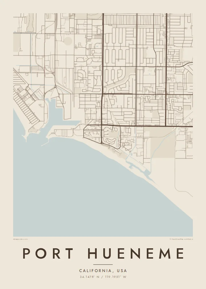
Port Hueneme sits on the coast of Ventura County, at the edge of the flat, farmed Oxnard Plain. The map is dominated by water. The Pacific shoreline runs along the south, and the deep, angular harbor basin cuts inland, while a neat suburban grid fills most of the remaining land.
The Port of Hueneme is the only deep-water harbor between Los Angeles and San Francisco and handles large volumes of vehicles and fresh produce. Next to it lies Naval Base Ventura County, long associated with the Navy Seabees, whose large fenced compound fills a big part of the city's footprint.
A Port Hueneme map poster shows these very different pieces side by side: the engineered geometry of the harbor, the broad blocks of the base, the residential streets and the public beach with its fishing pier. Beyond the coastline lie the Channel Islands, across the Santa Barbara Channel.
A narrow entrance channel opens into a deep, angular basin, the strongest man-made shape on the map and the reason the city grew here.
A wide sandy beach and pier line the southern edge of the city, drawing a clean coastline between the streets and the Pacific.
The naval base covers a large, carefully laid-out area beside the port, with long straight roads and open spaces unlike the surrounding neighbourhoods.
Kok tanim ab
Ayro, migaq hinnay kok tan xagar osis; gaba, ballaqa hinnay xiqa soorris.
Free preview qansarissi kee watermark-le. Daabbisimtaan kee HD fayla 300 DPI-l, 7,200 × 10,800 px fanah, watermark maleh ederimta.
Macah Port Hueneme
Many people pass through Port Hueneme on a Navy posting, which makes it a meaningful place for service families as well as for longtime locals. The map records a real chapter of life, with the harbor and beach at its centre.
Add a name, unit, date or a line of coordinates to make the poster personal. Choose from Classic black & white, Noir, Paper, Blueprint and Sand. Blueprint suits the port's engineered lines particularly well.
Port Hueneme poster orme| Maxxaacah ballaqa | Qeeqa | Faylal |
|---|---|---|
| 30 × 40 cm11.8 × 15.7″ | 3,543 × 4,724 px | PNG · PDF |
| 29.7 × 42 cm (A3)11.7 × 16.5″ | 3,508 × 4,961 px | PNG · PDF |
| 42 × 59.4 cm (A2)16.5 × 23.4″ | 4,961 × 7,016 px | PNG · PDF |
| 45.7 × 61 cm18 × 24″ | 5,400 × 7,200 px | PNG · PDF |
| 50 × 70 cm19.7 × 27.6″ | 5,906 × 8,268 px | PNG · PDF |
| 61 × 91.4 cm24 × 36″ | 7,200 × 10,800 px | PNG · PDF |
Tabbaltah, limo-wayta xaqqa-le ablo 900 px ballaqa le, asta le, iskiriinih keh tan. HD faylal gexsoh inkih addal 8× fanah qeeqa le, poster ballaqa inkih addal meqeh maxxaacimta.
Baxxaqqa qari le qandiy dooriy, tohuk lakal Daabbisimtah Poster — kutuk kee, faxximek, dirbaabu — hinnay HD Digital Fayla dooru. Checkout inki wagitti geytima, kaadu ku-orme page keenih adissa akke waqdi caagoy kummite.
Usuk 200 gsm-le catam kutuk warqatal, lica katiy caagitte $39-ik hane ayta 30 × 40 cm-ik 24 × 36″ fanah, xaagu keenil warreeh.
Ee. Sarrah-le dirbaabu doori — bad, gudduc, oak-le hinnay bad-madabuy. Usuk finqisiimam ellee sange qarab-le kaadu qari umukku iyya keenih taagu. Dirbaabu-le poster $99-ik hane, xaagu keenil warreeh.
Dirsa 60+ baaxoh bilsa. Poster kasa 30+ baaxoh nel print kaadu yan kee dirgeh kaxxa kee tanah printa, kee 3–7 xaqu ayyaamah yaaxigeeh. Xaaloo kee tracking "Ac Order" gexsitam. Kaadu baaxo 2–5 isbuuc yaaxigeeh, nanu dirsi yanin baaxoh sajiitah site ku kalah tekkeh.
Geytimeek 14 ayróy addal foto naah rubbaay, cisab-le daabbisiynah hinnay ku-lacay gacisnaah.
Ee. Tama page-l edito addal, migaaq, subtitle kee coordinates sarrah faxxem fanah badal, kaadu qande kee katiy doori. Daabbisimtah, dirbaabu-le kaadu digital orme inkih ku-design cagalah yekkelen.
$9 bacisak 300 DPI PNG kee daabbisimtah adissime PDF fayla lica katiy inkih, watermark maleh, ayyi meki daabbisimtah geeytitta. Cisab makkoysemty ana? Awqak, watermark-le free preview download-eh.
Xayyo
