Strait of Magellan
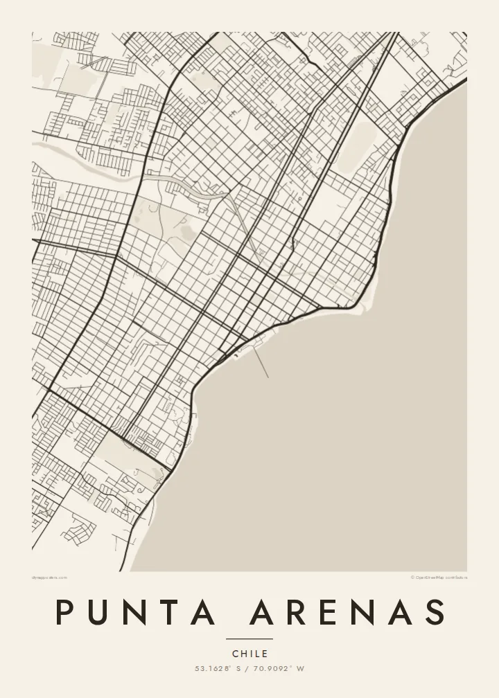
The city's whole eastern side faces the strait. On the poster it appears as a broad open plane, with the city running along one shore and Tierra del Fuego across the water.
Qeeqabak kaartah poster · Chile
53.1628° S / 70.9092° W
A windswept grid on the Strait of Magellan, where straight streets run down to the water facing Tierra del Fuego




Inki magaala, konoy gaba
Qande inkih tibbixeeh derre baguley table. Kulli qande missoowa caagid—daabbisimta, dirbaabu-le kaadu HD fayla akah.
 Cagalah pixels · 24 × 36″ daabbi fayla
Maxxaacah qeeqa
Tama usuk cagalah daabbi faylak 100% qambaala. Kulli poster — daabbisimta, dirbaabu-le kaadu download geytimta — ni-server-ittal 300 DPI-l ederimta, 7,200 × 10,800 pixels fanah, tokkel iyyi ellee catoy 24 × 36″ daabbi baxsi bahisak raaqu.
Gidarih


Kaarta
Punta Arenas stretches along the western shore of the Strait of Magellan and is one of the southernmost cities in the world. From above, it is a disciplined grid of straight streets and square blocks. The grid runs from the coastline up gentle slopes toward the hills and the Patagonian steppe. The Costanera road follows the shore, and to the east lies the open water of the strait, with Tierra del Fuego on the far side.
The city was founded in 1848 as a Chilean outpost. It prospered as a port on the route between the Atlantic and Pacific before the Panama Canal opened, and later as a centre of the sheep-farming trade. Its central square, Plaza Muñoz Gamero, is laid out around a monument to Magellan. A Punta Arenas map poster shows the plaza at the heart of a regular plan that seems built to hold firm against the wind.
In black and white, the contrast between land and sea is stark. The dense grid stops at a clean coastline, and the strait fills the rest of the frame as a single calm field. Small rivers and ravines come down from the hills and break into the rows of blocks. The result is a graphic image of a city at the edge of the continent.
The city's whole eastern side faces the strait. On the poster it appears as a broad open plane, with the city running along one shore and Tierra del Fuego across the water.
The main square sits at the centre of the grid, surrounded by regular blocks. The Magellan monument stands there, and the square is the anchor of the whole plan.
Straight streets climb from the coast toward the western hills in long parallel rows. They give the city its orderly, almost drafted look against the open landscape.
Kok tanim ab
Ayro, migaq hinnay kok tan xagar osis; gaba, ballaqa hinnay xiqa soorris.
Free preview qansarissi kee watermark-le. Daabbisimtaan kee HD fayla 300 DPI-l, 7,200 × 10,800 px fanah, watermark maleh ederimta.
Macah Punta Arenas
Punta Arenas is often a gateway to Torres del Paine, Antarctic voyages and Tierra del Fuego, so its map works as a keepsake of a journey to the far south. For residents, it is a striking portrait of a city defined by its coastline.
You can personalise the title, subtitle and coordinates line, for example with an expedition date or a family name. Choose from five styles: Classic black & white, Noir, Paper, Blueprint and Sand. Blueprint suits the seafaring history of the port. Order it as a digital file or as a printed poster.
Punta Arenas poster orme| Maxxaacah ballaqa | Qeeqa | Faylal |
|---|---|---|
| 30 × 40 cm11.8 × 15.7″ | 3,543 × 4,724 px | PNG · PDF |
| 29.7 × 42 cm (A3)11.7 × 16.5″ | 3,508 × 4,961 px | PNG · PDF |
| 42 × 59.4 cm (A2)16.5 × 23.4″ | 4,961 × 7,016 px | PNG · PDF |
| 45.7 × 61 cm18 × 24″ | 5,400 × 7,200 px | PNG · PDF |
| 50 × 70 cm19.7 × 27.6″ | 5,906 × 8,268 px | PNG · PDF |
| 61 × 91.4 cm24 × 36″ | 7,200 × 10,800 px | PNG · PDF |
Tabbaltah, limo-wayta xaqqa-le ablo 900 px ballaqa le, asta le, iskiriinih keh tan. HD faylal gexsoh inkih addal 8× fanah qeeqa le, poster ballaqa inkih addal meqeh maxxaacimta.
Baxxaqqa qari le qandiy dooriy, tohuk lakal Daabbisimtah Poster — kutuk kee, faxximek, dirbaabu — hinnay HD Digital Fayla dooru. Checkout inki wagitti geytima, kaadu ku-orme page keenih adissa akke waqdi caagoy kummite.
Usuk 200 gsm-le catam kutuk warqatal, lica katiy caagitte $39-ik hane ayta 30 × 40 cm-ik 24 × 36″ fanah, xaagu keenil warreeh.
Ee. Sarrah-le dirbaabu doori — bad, gudduc, oak-le hinnay bad-madabuy. Usuk finqisiimam ellee sange qarab-le kaadu qari umukku iyya keenih taagu. Dirbaabu-le poster $99-ik hane, xaagu keenil warreeh.
Dirsa 60+ baaxoh bilsa. Poster kasa 30+ baaxoh nel print kaadu yan kee dirgeh kaxxa kee tanah printa, kee 3–7 xaqu ayyaamah yaaxigeeh. Xaaloo kee tracking "Ac Order" gexsitam. Kaadu baaxo 2–5 isbuuc yaaxigeeh, nanu dirsi yanin baaxoh sajiitah site ku kalah tekkeh.
Geytimeek 14 ayróy addal foto naah rubbaay, cisab-le daabbisiynah hinnay ku-lacay gacisnaah.
Ee. Tama page-l edito addal, migaaq, subtitle kee coordinates sarrah faxxem fanah badal, kaadu qande kee katiy doori. Daabbisimtah, dirbaabu-le kaadu digital orme inkih ku-design cagalah yekkelen.
$9 bacisak 300 DPI PNG kee daabbisimtah adissime PDF fayla lica katiy inkih, watermark maleh, ayyi meki daabbisimtah geeytitta. Cisab makkoysemty ana? Awqak, watermark-le free preview download-eh.
Xayyo
