Whitewater River gorge
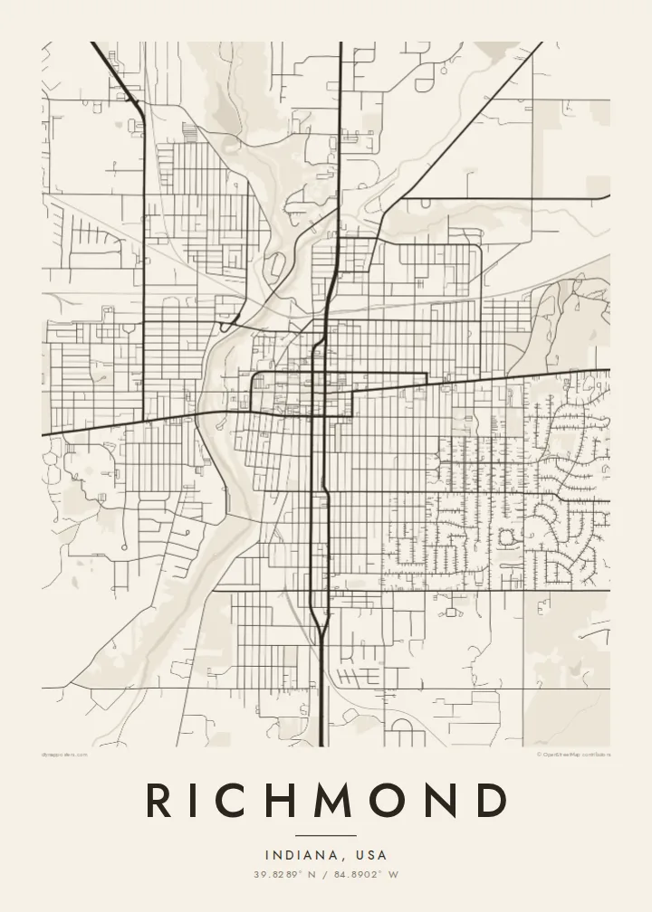
The river runs through a steep, wooded gorge that splits the city grid in two, with parkland along its banks and only a few bridges across.
Qeeqabak kaartah poster · United States
39.8289° N / 84.8902° W
An Indiana grid split by the wooded gorge of the Whitewater River and crossed by the old National Road




Inki magaala, konoy gaba
Qande inkih tibbixeeh derre baguley table. Kulli qande missoowa caagid—daabbisimta, dirbaabu-le kaadu HD fayla akah.
 Cagalah pixels · 24 × 36″ daabbi fayla
Maxxaacah qeeqa
Tama usuk cagalah daabbi faylak 100% qambaala. Kulli poster — daabbisimta, dirbaabu-le kaadu download geytimta — ni-server-ittal 300 DPI-l ederimta, 7,200 × 10,800 pixels fanah, tokkel iyyi ellee catoy 24 × 36″ daabbi baxsi bahisak raaqu.
Gidarih


Kaarta
Richmond lies on the eastern edge of Indiana, right against the Ohio state line, and it is the seat of Wayne County. The historic National Road, now US 40, runs through the city as Main Street, and much of the downtown grid is aligned to it. The most striking feature from above is the Whitewater River, which cuts a deep, wooded gorge through the city from north to south.
The gorge divides the grid into an east side and a west side, joined by a few bridges, and the parkland along it shows as a long ribbon of empty space. Richmond was settled largely by Quakers, and Earlham College, a Quaker institution, occupies a campus on the west side. The city also has a place in music history: Gennett Records recorded early jazz here in the 1920s, including King Oliver's band with a young Louis Armstrong.
A Richmond map poster shows all of this clearly. The long line of Main Street, the regular blocks on both sides and the curving green break of the gorge make for a well-balanced composition. It works for Earlham alumni, for people who grew up in Wayne County and for anyone with an interest in the Midwest's older towns.
The river runs through a steep, wooded gorge that splits the city grid in two, with parkland along its banks and only a few bridges across.
US 40, the old National Road, passes straight through as Main Street and sets the orientation of the downtown blocks around it.
On the west side, the Quaker-founded college's grounds show as a looser arrangement of paths and buildings set within open lawns.
Kok tanim ab
Ayro, migaq hinnay kok tan xagar osis; gaba, ballaqa hinnay xiqa soorris.
Free preview qansarissi kee watermark-le. Daabbisimtaan kee HD fayla 300 DPI-l, 7,200 × 10,800 px fanah, watermark maleh ederimta.
Macah Richmond
Richmond is a map many people carry with them: a college town for some, a hometown for others, a stop on an old road for those who drove through. The gorge makes it recognisable at a glance, even printed in simple lines.
Change the title and subtitle to mark a graduation year or a family address, and adjust the coordinates line. Choose from five styles, including Paper and Noir, and order a framed print or download HD files for $9.
Richmond poster orme| Maxxaacah ballaqa | Qeeqa | Faylal |
|---|---|---|
| 30 × 40 cm11.8 × 15.7″ | 3,543 × 4,724 px | PNG · PDF |
| 29.7 × 42 cm (A3)11.7 × 16.5″ | 3,508 × 4,961 px | PNG · PDF |
| 42 × 59.4 cm (A2)16.5 × 23.4″ | 4,961 × 7,016 px | PNG · PDF |
| 45.7 × 61 cm18 × 24″ | 5,400 × 7,200 px | PNG · PDF |
| 50 × 70 cm19.7 × 27.6″ | 5,906 × 8,268 px | PNG · PDF |
| 61 × 91.4 cm24 × 36″ | 7,200 × 10,800 px | PNG · PDF |
Tabbaltah, limo-wayta xaqqa-le ablo 900 px ballaqa le, asta le, iskiriinih keh tan. HD faylal gexsoh inkih addal 8× fanah qeeqa le, poster ballaqa inkih addal meqeh maxxaacimta.
Baxxaqqa qari le qandiy dooriy, tohuk lakal Daabbisimtah Poster — kutuk kee, faxximek, dirbaabu — hinnay HD Digital Fayla dooru. Checkout inki wagitti geytima, kaadu ku-orme page keenih adissa akke waqdi caagoy kummite.
Usuk 200 gsm-le catam kutuk warqatal, lica katiy caagitte $39-ik hane ayta 30 × 40 cm-ik 24 × 36″ fanah, xaagu keenil warreeh.
Ee. Sarrah-le dirbaabu doori — bad, gudduc, oak-le hinnay bad-madabuy. Usuk finqisiimam ellee sange qarab-le kaadu qari umukku iyya keenih taagu. Dirbaabu-le poster $99-ik hane, xaagu keenil warreeh.
Dirsa 60+ baaxoh bilsa. Poster kasa 30+ baaxoh nel print kaadu yan kee dirgeh kaxxa kee tanah printa, kee 3–7 xaqu ayyaamah yaaxigeeh. Xaaloo kee tracking "Ac Order" gexsitam. Kaadu baaxo 2–5 isbuuc yaaxigeeh, nanu dirsi yanin baaxoh sajiitah site ku kalah tekkeh.
Geytimeek 14 ayróy addal foto naah rubbaay, cisab-le daabbisiynah hinnay ku-lacay gacisnaah.
Ee. Tama page-l edito addal, migaaq, subtitle kee coordinates sarrah faxxem fanah badal, kaadu qande kee katiy doori. Daabbisimtah, dirbaabu-le kaadu digital orme inkih ku-design cagalah yekkelen.
$9 bacisak 300 DPI PNG kee daabbisimtah adissime PDF fayla lica katiy inkih, watermark maleh, ayyi meki daabbisimtah geeytitta. Cisab makkoysemty ana? Awqak, watermark-le free preview download-eh.
